| Hinkley Point |
|
EWL 1:1 yr
LISFLOOD-FP model results for Hinkley Point model domain. The blanked out area near to Hinkley Point is covered by existing pre-operational and operational safety cases.
LISFLOOD-FP model results for Hinkley Point model domain. The blanked out area near to Hinkley Point is covered by existing pre-operational and operational safety cases.
LISFLOOD-FP model results for Hinkley Point model domain. The blanked out area near to Hinkley Point is covered by existing pre-operational and operational safety cases.
LISFLOOD-FP model results for Hinkley Point model domain. The blanked out area near to Hinkley Point is covered by existing pre-operational and operational safety cases.
LISFLOOD-FP model results for Hinkley Point model domain. The blanked out area near to Hinkley Point is covered by existing pre-operational and operational safety cases.
LISFLOOD-FP model results for Hinkley Point model domain. The blanked out area near to Hinkley Point is covered by existing pre-operational and operational safety cases.
LISFLOOD-FP model results for Hinkley Point model domain. The blanked out area near to Hinkley Point is covered by existing pre-operational and operational safety cases.
LISFLOOD-FP model results for Hinkley Point model domain. The blanked out area near to Hinkley Point is covered by existing pre-operational and operational safety cases.
LISFLOOD-FP model results for Hinkley Point model domain. The blanked out area near to Hinkley Point is covered by existing pre-operational and operational safety cases.
LISFLOOD-FP model results for Hinkley Point model domain. The blanked out area near to Hinkley Point is covered by existing pre-operational and operational safety cases.
LISFLOOD-FP model results for Hinkley Point model domain. The blanked out area near to Hinkley Point is covered by existing pre-operational and operational safety cases.
LISFLOOD-FP model results for Hinkley Point model domain. The blanked out area near to Hinkley Point is covered by existing pre-operational and operational safety cases.
LISFLOOD-FP model results for Hinkley Point model domain. The blanked out area near to Hinkley Point is covered by existing pre-operational and operational safety cases.
LISFLOOD-FP model results for Hinkley Point model domain. The blanked out area near to Hinkley Point is covered by existing pre-operational and operational safety cases.
LISFLOOD-FP model results for Hinkley Point model domain. The blanked out area near to Hinkley Point is covered by existing pre-operational and operational safety cases.
LISFLOOD-FP model results for Hinkley Point model domain. The blanked out area near to Hinkley Point is covered by existing pre-operational and operational safety cases.
LISFLOOD-FP model results for Hinkley Point model domain. The blanked out area near to Hinkley Point is covered by existing pre-operational and operational safety cases.
LISFLOOD-FP model results for Hinkley Point model domain. The blanked out area near to Hinkley Point is covered by existing pre-operational and operational safety cases.
LISFLOOD-FP model results for Hinkley Point model domain. The blanked out area near to Hinkley Point is covered by existing pre-operational and operational safety cases.
LISFLOOD-FP model results for Hinkley Point model domain. The blanked out area near to Hinkley Point is covered by existing pre-operational and operational safety cases.
LISFLOOD-FP model results for Hinkley Point model domain. The blanked out area near to Hinkley Point is covered by existing pre-operational and operational safety cases.
LISFLOOD-FP model results for Hinkley Point model domain. The blanked out area near to Hinkley Point is covered by existing pre-operational and operational safety cases.
LISFLOOD-FP model results for Hinkley Point model domain. The blanked out area near to Hinkley Point is covered by existing pre-operational and operational safety cases.
LISFLOOD-FP model results for Hinkley Point model domain. The blanked out area near to Hinkley Point is covered by existing pre-operational and operational safety cases.
LISFLOOD-FP model results for Hinkley Point model domain. The blanked out area near to Hinkley Point is covered by existing pre-operational and operational safety cases.
LISFLOOD-FP model results for Hinkley Point model domain. The blanked out area near to Hinkley Point is covered by existing pre-operational and operational safety cases.
LISFLOOD-FP model results for Hinkley Point model domain. The blanked out area near to Hinkley Point is covered by existing pre-operational and operational safety cases.
LISFLOOD-FP model results for Hinkley Point model domain. The blanked out area near to Hinkley Point is covered by existing pre-operational and operational safety cases.
LISFLOOD-FP model results for Hinkley Point model domain. The blanked out area near to Hinkley Point is covered by existing pre-operational and operational safety cases.
LISFLOOD-FP model results for Hinkley Point model domain. The blanked out area near to Hinkley Point is covered by existing pre-operational and operational safety cases.
LISFLOOD-FP model results for Hinkley Point model domain. The blanked out area near to Hinkley Point is covered by existing pre-operational and operational safety cases.
LISFLOOD-FP model results for Hinkley Point model domain. The blanked out area near to Hinkley Point is covered by existing pre-operational and operational safety cases.
LISFLOOD-FP model results for Hinkley Point model domain. The blanked out area near to Hinkley Point is covered by existing pre-operational and operational safety cases.
LISFLOOD-FP model results for Hinkley Point model domain. The blanked out area near to Hinkley Point is covered by existing pre-operational and operational safety cases.
LISFLOOD-FP model results for Hinkley Point model domain. The blanked out area near to Hinkley Point is covered by existing pre-operational and operational safety cases.
EWL 1:2 yr
LISFLOOD-FP model results for Hinkley Point model domain. The blanked out area near to Hinkley Point is covered by existing pre-operational and operational safety cases.
LISFLOOD-FP model results for Hinkley Point model domain. The blanked out area near to Hinkley Point is covered by existing pre-operational and operational safety cases.
LISFLOOD-FP model results for Hinkley Point model domain. The blanked out area near to Hinkley Point is covered by existing pre-operational and operational safety cases.
LISFLOOD-FP model results for Hinkley Point model domain. The blanked out area near to Hinkley Point is covered by existing pre-operational and operational safety cases.
LISFLOOD-FP model results for Hinkley Point model domain. The blanked out area near to Hinkley Point is covered by existing pre-operational and operational safety cases.
LISFLOOD-FP model results for Hinkley Point model domain. The blanked out area near to Hinkley Point is covered by existing pre-operational and operational safety cases.
LISFLOOD-FP model results for Hinkley Point model domain. The blanked out area near to Hinkley Point is covered by existing pre-operational and operational safety cases.
LISFLOOD-FP model results for Hinkley Point model domain. The blanked out area near to Hinkley Point is covered by existing pre-operational and operational safety cases.
LISFLOOD-FP model results for Hinkley Point model domain. The blanked out area near to Hinkley Point is covered by existing pre-operational and operational safety cases.
LISFLOOD-FP model results for Hinkley Point model domain. The blanked out area near to Hinkley Point is covered by existing pre-operational and operational safety cases.
LISFLOOD-FP model results for Hinkley Point model domain. The blanked out area near to Hinkley Point is covered by existing pre-operational and operational safety cases.
LISFLOOD-FP model results for Hinkley Point model domain. The blanked out area near to Hinkley Point is covered by existing pre-operational and operational safety cases.
LISFLOOD-FP model results for Hinkley Point model domain. The blanked out area near to Hinkley Point is covered by existing pre-operational and operational safety cases.
LISFLOOD-FP model results for Hinkley Point model domain. The blanked out area near to Hinkley Point is covered by existing pre-operational and operational safety cases.
LISFLOOD-FP model results for Hinkley Point model domain. The blanked out area near to Hinkley Point is covered by existing pre-operational and operational safety cases.
LISFLOOD-FP model results for Hinkley Point model domain. The blanked out area near to Hinkley Point is covered by existing pre-operational and operational safety cases.
LISFLOOD-FP model results for Hinkley Point model domain. The blanked out area near to Hinkley Point is covered by existing pre-operational and operational safety cases.
LISFLOOD-FP model results for Hinkley Point model domain. The blanked out area near to Hinkley Point is covered by existing pre-operational and operational safety cases.
LISFLOOD-FP model results for Hinkley Point model domain. The blanked out area near to Hinkley Point is covered by existing pre-operational and operational safety cases.
LISFLOOD-FP model results for Hinkley Point model domain. The blanked out area near to Hinkley Point is covered by existing pre-operational and operational safety cases.
LISFLOOD-FP model results for Hinkley Point model domain. The blanked out area near to Hinkley Point is covered by existing pre-operational and operational safety cases.
LISFLOOD-FP model results for Hinkley Point model domain. The blanked out area near to Hinkley Point is covered by existing pre-operational and operational safety cases.
LISFLOOD-FP model results for Hinkley Point model domain. The blanked out area near to Hinkley Point is covered by existing pre-operational and operational safety cases.
LISFLOOD-FP model results for Hinkley Point model domain. The blanked out area near to Hinkley Point is covered by existing pre-operational and operational safety cases.
LISFLOOD-FP model results for Hinkley Point model domain. The blanked out area near to Hinkley Point is covered by existing pre-operational and operational safety cases.
LISFLOOD-FP model results for Hinkley Point model domain. The blanked out area near to Hinkley Point is covered by existing pre-operational and operational safety cases.
LISFLOOD-FP model results for Hinkley Point model domain. The blanked out area near to Hinkley Point is covered by existing pre-operational and operational safety cases.
LISFLOOD-FP model results for Hinkley Point model domain. The blanked out area near to Hinkley Point is covered by existing pre-operational and operational safety cases.
LISFLOOD-FP model results for Hinkley Point model domain. The blanked out area near to Hinkley Point is covered by existing pre-operational and operational safety cases.
LISFLOOD-FP model results for Hinkley Point model domain. The blanked out area near to Hinkley Point is covered by existing pre-operational and operational safety cases.
LISFLOOD-FP model results for Hinkley Point model domain. The blanked out area near to Hinkley Point is covered by existing pre-operational and operational safety cases.
LISFLOOD-FP model results for Hinkley Point model domain. The blanked out area near to Hinkley Point is covered by existing pre-operational and operational safety cases.
LISFLOOD-FP model results for Hinkley Point model domain. The blanked out area near to Hinkley Point is covered by existing pre-operational and operational safety cases.
LISFLOOD-FP model results for Hinkley Point model domain. The blanked out area near to Hinkley Point is covered by existing pre-operational and operational safety cases.
LISFLOOD-FP model results for Hinkley Point model domain. The blanked out area near to Hinkley Point is covered by existing pre-operational and operational safety cases.
EWL 1:5 yr
LISFLOOD-FP model results for Hinkley Point model domain. The blanked out area near to Hinkley Point is covered by existing pre-operational and operational safety cases.
LISFLOOD-FP model results for Hinkley Point model domain. The blanked out area near to Hinkley Point is covered by existing pre-operational and operational safety cases.
LISFLOOD-FP model results for Hinkley Point model domain. The blanked out area near to Hinkley Point is covered by existing pre-operational and operational safety cases.
LISFLOOD-FP model results for Hinkley Point model domain. The blanked out area near to Hinkley Point is covered by existing pre-operational and operational safety cases.
LISFLOOD-FP model results for Hinkley Point model domain. The blanked out area near to Hinkley Point is covered by existing pre-operational and operational safety cases.
LISFLOOD-FP model results for Hinkley Point model domain. The blanked out area near to Hinkley Point is covered by existing pre-operational and operational safety cases.
LISFLOOD-FP model results for Hinkley Point model domain. The blanked out area near to Hinkley Point is covered by existing pre-operational and operational safety cases.
LISFLOOD-FP model results for Hinkley Point model domain. The blanked out area near to Hinkley Point is covered by existing pre-operational and operational safety cases.
LISFLOOD-FP model results for Hinkley Point model domain. The blanked out area near to Hinkley Point is covered by existing pre-operational and operational safety cases.
LISFLOOD-FP model results for Hinkley Point model domain. The blanked out area near to Hinkley Point is covered by existing pre-operational and operational safety cases.
LISFLOOD-FP model results for Hinkley Point model domain. The blanked out area near to Hinkley Point is covered by existing pre-operational and operational safety cases.
LISFLOOD-FP model results for Hinkley Point model domain. The blanked out area near to Hinkley Point is covered by existing pre-operational and operational safety cases.
LISFLOOD-FP model results for Hinkley Point model domain. The blanked out area near to Hinkley Point is covered by existing pre-operational and operational safety cases.
LISFLOOD-FP model results for Hinkley Point model domain. The blanked out area near to Hinkley Point is covered by existing pre-operational and operational safety cases.
LISFLOOD-FP model results for Hinkley Point model domain. The blanked out area near to Hinkley Point is covered by existing pre-operational and operational safety cases.
LISFLOOD-FP model results for Hinkley Point model domain. The blanked out area near to Hinkley Point is covered by existing pre-operational and operational safety cases.
LISFLOOD-FP model results for Hinkley Point model domain. The blanked out area near to Hinkley Point is covered by existing pre-operational and operational safety cases.
LISFLOOD-FP model results for Hinkley Point model domain. The blanked out area near to Hinkley Point is covered by existing pre-operational and operational safety cases.
LISFLOOD-FP model results for Hinkley Point model domain. The blanked out area near to Hinkley Point is covered by existing pre-operational and operational safety cases.
LISFLOOD-FP model results for Hinkley Point model domain. The blanked out area near to Hinkley Point is covered by existing pre-operational and operational safety cases.
LISFLOOD-FP model results for Hinkley Point model domain. The blanked out area near to Hinkley Point is covered by existing pre-operational and operational safety cases.
LISFLOOD-FP model results for Hinkley Point model domain. The blanked out area near to Hinkley Point is covered by existing pre-operational and operational safety cases.
LISFLOOD-FP model results for Hinkley Point model domain. The blanked out area near to Hinkley Point is covered by existing pre-operational and operational safety cases.
LISFLOOD-FP model results for Hinkley Point model domain. The blanked out area near to Hinkley Point is covered by existing pre-operational and operational safety cases.
LISFLOOD-FP model results for Hinkley Point model domain. The blanked out area near to Hinkley Point is covered by existing pre-operational and operational safety cases.
LISFLOOD-FP model results for Hinkley Point model domain. The blanked out area near to Hinkley Point is covered by existing pre-operational and operational safety cases.
LISFLOOD-FP model results for Hinkley Point model domain. The blanked out area near to Hinkley Point is covered by existing pre-operational and operational safety cases.
LISFLOOD-FP model results for Hinkley Point model domain. The blanked out area near to Hinkley Point is covered by existing pre-operational and operational safety cases.
LISFLOOD-FP model results for Hinkley Point model domain. The blanked out area near to Hinkley Point is covered by existing pre-operational and operational safety cases.
LISFLOOD-FP model results for Hinkley Point model domain. The blanked out area near to Hinkley Point is covered by existing pre-operational and operational safety cases.
LISFLOOD-FP model results for Hinkley Point model domain. The blanked out area near to Hinkley Point is covered by existing pre-operational and operational safety cases.
LISFLOOD-FP model results for Hinkley Point model domain. The blanked out area near to Hinkley Point is covered by existing pre-operational and operational safety cases.
LISFLOOD-FP model results for Hinkley Point model domain. The blanked out area near to Hinkley Point is covered by existing pre-operational and operational safety cases.
LISFLOOD-FP model results for Hinkley Point model domain. The blanked out area near to Hinkley Point is covered by existing pre-operational and operational safety cases.
LISFLOOD-FP model results for Hinkley Point model domain. The blanked out area near to Hinkley Point is covered by existing pre-operational and operational safety cases.
EWL 1:10 yr
LISFLOOD-FP model results for Hinkley Point model domain. The blanked out area near to Hinkley Point is covered by existing pre-operational and operational safety cases.
LISFLOOD-FP model results for Hinkley Point model domain. The blanked out area near to Hinkley Point is covered by existing pre-operational and operational safety cases.
LISFLOOD-FP model results for Hinkley Point model domain. The blanked out area near to Hinkley Point is covered by existing pre-operational and operational safety cases.
LISFLOOD-FP model results for Hinkley Point model domain. The blanked out area near to Hinkley Point is covered by existing pre-operational and operational safety cases.
LISFLOOD-FP model results for Hinkley Point model domain. The blanked out area near to Hinkley Point is covered by existing pre-operational and operational safety cases.
LISFLOOD-FP model results for Hinkley Point model domain. The blanked out area near to Hinkley Point is covered by existing pre-operational and operational safety cases.
LISFLOOD-FP model results for Hinkley Point model domain. The blanked out area near to Hinkley Point is covered by existing pre-operational and operational safety cases.
LISFLOOD-FP model results for Hinkley Point model domain. The blanked out area near to Hinkley Point is covered by existing pre-operational and operational safety cases.
LISFLOOD-FP model results for Hinkley Point model domain. The blanked out area near to Hinkley Point is covered by existing pre-operational and operational safety cases.
LISFLOOD-FP model results for Hinkley Point model domain. The blanked out area near to Hinkley Point is covered by existing pre-operational and operational safety cases.
LISFLOOD-FP model results for Hinkley Point model domain. The blanked out area near to Hinkley Point is covered by existing pre-operational and operational safety cases.
LISFLOOD-FP model results for Hinkley Point model domain. The blanked out area near to Hinkley Point is covered by existing pre-operational and operational safety cases.
LISFLOOD-FP model results for Hinkley Point model domain. The blanked out area near to Hinkley Point is covered by existing pre-operational and operational safety cases.
LISFLOOD-FP model results for Hinkley Point model domain. The blanked out area near to Hinkley Point is covered by existing pre-operational and operational safety cases.
LISFLOOD-FP model results for Hinkley Point model domain. The blanked out area near to Hinkley Point is covered by existing pre-operational and operational safety cases.
LISFLOOD-FP model results for Hinkley Point model domain. The blanked out area near to Hinkley Point is covered by existing pre-operational and operational safety cases.
LISFLOOD-FP model results for Hinkley Point model domain. The blanked out area near to Hinkley Point is covered by existing pre-operational and operational safety cases.
LISFLOOD-FP model results for Hinkley Point model domain. The blanked out area near to Hinkley Point is covered by existing pre-operational and operational safety cases.
LISFLOOD-FP model results for Hinkley Point model domain. The blanked out area near to Hinkley Point is covered by existing pre-operational and operational safety cases.
LISFLOOD-FP model results for Hinkley Point model domain. The blanked out area near to Hinkley Point is covered by existing pre-operational and operational safety cases.
LISFLOOD-FP model results for Hinkley Point model domain. The blanked out area near to Hinkley Point is covered by existing pre-operational and operational safety cases.
LISFLOOD-FP model results for Hinkley Point model domain. The blanked out area near to Hinkley Point is covered by existing pre-operational and operational safety cases.
LISFLOOD-FP model results for Hinkley Point model domain. The blanked out area near to Hinkley Point is covered by existing pre-operational and operational safety cases.
LISFLOOD-FP model results for Hinkley Point model domain. The blanked out area near to Hinkley Point is covered by existing pre-operational and operational safety cases.
LISFLOOD-FP model results for Hinkley Point model domain. The blanked out area near to Hinkley Point is covered by existing pre-operational and operational safety cases.
LISFLOOD-FP model results for Hinkley Point model domain. The blanked out area near to Hinkley Point is covered by existing pre-operational and operational safety cases.
LISFLOOD-FP model results for Hinkley Point model domain. The blanked out area near to Hinkley Point is covered by existing pre-operational and operational safety cases.
LISFLOOD-FP model results for Hinkley Point model domain. The blanked out area near to Hinkley Point is covered by existing pre-operational and operational safety cases.
LISFLOOD-FP model results for Hinkley Point model domain. The blanked out area near to Hinkley Point is covered by existing pre-operational and operational safety cases.
LISFLOOD-FP model results for Hinkley Point model domain. The blanked out area near to Hinkley Point is covered by existing pre-operational and operational safety cases.
LISFLOOD-FP model results for Hinkley Point model domain. The blanked out area near to Hinkley Point is covered by existing pre-operational and operational safety cases.
LISFLOOD-FP model results for Hinkley Point model domain. The blanked out area near to Hinkley Point is covered by existing pre-operational and operational safety cases.
LISFLOOD-FP model results for Hinkley Point model domain. The blanked out area near to Hinkley Point is covered by existing pre-operational and operational safety cases.
LISFLOOD-FP model results for Hinkley Point model domain. The blanked out area near to Hinkley Point is covered by existing pre-operational and operational safety cases.
LISFLOOD-FP model results for Hinkley Point model domain. The blanked out area near to Hinkley Point is covered by existing pre-operational and operational safety cases.
EWL 1:20 yr
LISFLOOD-FP model results for Hinkley Point model domain. The blanked out area near to Hinkley Point is covered by existing pre-operational and operational safety cases.
LISFLOOD-FP model results for Hinkley Point model domain. The blanked out area near to Hinkley Point is covered by existing pre-operational and operational safety cases.
LISFLOOD-FP model results for Hinkley Point model domain. The blanked out area near to Hinkley Point is covered by existing pre-operational and operational safety cases.
LISFLOOD-FP model results for Hinkley Point model domain. The blanked out area near to Hinkley Point is covered by existing pre-operational and operational safety cases.
LISFLOOD-FP model results for Hinkley Point model domain. The blanked out area near to Hinkley Point is covered by existing pre-operational and operational safety cases.
LISFLOOD-FP model results for Hinkley Point model domain. The blanked out area near to Hinkley Point is covered by existing pre-operational and operational safety cases.
LISFLOOD-FP model results for Hinkley Point model domain. The blanked out area near to Hinkley Point is covered by existing pre-operational and operational safety cases.
LISFLOOD-FP model results for Hinkley Point model domain. The blanked out area near to Hinkley Point is covered by existing pre-operational and operational safety cases.
LISFLOOD-FP model results for Hinkley Point model domain. The blanked out area near to Hinkley Point is covered by existing pre-operational and operational safety cases.
LISFLOOD-FP model results for Hinkley Point model domain. The blanked out area near to Hinkley Point is covered by existing pre-operational and operational safety cases.
LISFLOOD-FP model results for Hinkley Point model domain. The blanked out area near to Hinkley Point is covered by existing pre-operational and operational safety cases.
LISFLOOD-FP model results for Hinkley Point model domain. The blanked out area near to Hinkley Point is covered by existing pre-operational and operational safety cases.
LISFLOOD-FP model results for Hinkley Point model domain. The blanked out area near to Hinkley Point is covered by existing pre-operational and operational safety cases.
LISFLOOD-FP model results for Hinkley Point model domain. The blanked out area near to Hinkley Point is covered by existing pre-operational and operational safety cases.
LISFLOOD-FP model results for Hinkley Point model domain. The blanked out area near to Hinkley Point is covered by existing pre-operational and operational safety cases.
LISFLOOD-FP model results for Hinkley Point model domain. The blanked out area near to Hinkley Point is covered by existing pre-operational and operational safety cases.
LISFLOOD-FP model results for Hinkley Point model domain. The blanked out area near to Hinkley Point is covered by existing pre-operational and operational safety cases.
LISFLOOD-FP model results for Hinkley Point model domain. The blanked out area near to Hinkley Point is covered by existing pre-operational and operational safety cases.
LISFLOOD-FP model results for Hinkley Point model domain. The blanked out area near to Hinkley Point is covered by existing pre-operational and operational safety cases.
LISFLOOD-FP model results for Hinkley Point model domain. The blanked out area near to Hinkley Point is covered by existing pre-operational and operational safety cases.
LISFLOOD-FP model results for Hinkley Point model domain. The blanked out area near to Hinkley Point is covered by existing pre-operational and operational safety cases.
LISFLOOD-FP model results for Hinkley Point model domain. The blanked out area near to Hinkley Point is covered by existing pre-operational and operational safety cases.
LISFLOOD-FP model results for Hinkley Point model domain. The blanked out area near to Hinkley Point is covered by existing pre-operational and operational safety cases.
LISFLOOD-FP model results for Hinkley Point model domain. The blanked out area near to Hinkley Point is covered by existing pre-operational and operational safety cases.
LISFLOOD-FP model results for Hinkley Point model domain. The blanked out area near to Hinkley Point is covered by existing pre-operational and operational safety cases.
LISFLOOD-FP model results for Hinkley Point model domain. The blanked out area near to Hinkley Point is covered by existing pre-operational and operational safety cases.
LISFLOOD-FP model results for Hinkley Point model domain. The blanked out area near to Hinkley Point is covered by existing pre-operational and operational safety cases.
LISFLOOD-FP model results for Hinkley Point model domain. The blanked out area near to Hinkley Point is covered by existing pre-operational and operational safety cases.
LISFLOOD-FP model results for Hinkley Point model domain. The blanked out area near to Hinkley Point is covered by existing pre-operational and operational safety cases.
LISFLOOD-FP model results for Hinkley Point model domain. The blanked out area near to Hinkley Point is covered by existing pre-operational and operational safety cases.
LISFLOOD-FP model results for Hinkley Point model domain. The blanked out area near to Hinkley Point is covered by existing pre-operational and operational safety cases.
LISFLOOD-FP model results for Hinkley Point model domain. The blanked out area near to Hinkley Point is covered by existing pre-operational and operational safety cases.
LISFLOOD-FP model results for Hinkley Point model domain. The blanked out area near to Hinkley Point is covered by existing pre-operational and operational safety cases.
LISFLOOD-FP model results for Hinkley Point model domain. The blanked out area near to Hinkley Point is covered by existing pre-operational and operational safety cases.
LISFLOOD-FP model results for Hinkley Point model domain. The blanked out area near to Hinkley Point is covered by existing pre-operational and operational safety cases.
EWL 1:25 yr
LISFLOOD-FP model results for Hinkley Point model domain. The blanked out area near to Hinkley Point is covered by existing pre-operational and operational safety cases.
LISFLOOD-FP model results for Hinkley Point model domain. The blanked out area near to Hinkley Point is covered by existing pre-operational and operational safety cases.
LISFLOOD-FP model results for Hinkley Point model domain. The blanked out area near to Hinkley Point is covered by existing pre-operational and operational safety cases.
LISFLOOD-FP model results for Hinkley Point model domain. The blanked out area near to Hinkley Point is covered by existing pre-operational and operational safety cases.
LISFLOOD-FP model results for Hinkley Point model domain. The blanked out area near to Hinkley Point is covered by existing pre-operational and operational safety cases.
LISFLOOD-FP model results for Hinkley Point model domain. The blanked out area near to Hinkley Point is covered by existing pre-operational and operational safety cases.
LISFLOOD-FP model results for Hinkley Point model domain. The blanked out area near to Hinkley Point is covered by existing pre-operational and operational safety cases.
LISFLOOD-FP model results for Hinkley Point model domain. The blanked out area near to Hinkley Point is covered by existing pre-operational and operational safety cases.
LISFLOOD-FP model results for Hinkley Point model domain. The blanked out area near to Hinkley Point is covered by existing pre-operational and operational safety cases.
LISFLOOD-FP model results for Hinkley Point model domain. The blanked out area near to Hinkley Point is covered by existing pre-operational and operational safety cases.
LISFLOOD-FP model results for Hinkley Point model domain. The blanked out area near to Hinkley Point is covered by existing pre-operational and operational safety cases.
LISFLOOD-FP model results for Hinkley Point model domain. The blanked out area near to Hinkley Point is covered by existing pre-operational and operational safety cases.
LISFLOOD-FP model results for Hinkley Point model domain. The blanked out area near to Hinkley Point is covered by existing pre-operational and operational safety cases.
LISFLOOD-FP model results for Hinkley Point model domain. The blanked out area near to Hinkley Point is covered by existing pre-operational and operational safety cases.
LISFLOOD-FP model results for Hinkley Point model domain. The blanked out area near to Hinkley Point is covered by existing pre-operational and operational safety cases.
LISFLOOD-FP model results for Hinkley Point model domain. The blanked out area near to Hinkley Point is covered by existing pre-operational and operational safety cases.
LISFLOOD-FP model results for Hinkley Point model domain. The blanked out area near to Hinkley Point is covered by existing pre-operational and operational safety cases.
LISFLOOD-FP model results for Hinkley Point model domain. The blanked out area near to Hinkley Point is covered by existing pre-operational and operational safety cases.
LISFLOOD-FP model results for Hinkley Point model domain. The blanked out area near to Hinkley Point is covered by existing pre-operational and operational safety cases.
LISFLOOD-FP model results for Hinkley Point model domain. The blanked out area near to Hinkley Point is covered by existing pre-operational and operational safety cases.
LISFLOOD-FP model results for Hinkley Point model domain. The blanked out area near to Hinkley Point is covered by existing pre-operational and operational safety cases.
LISFLOOD-FP model results for Hinkley Point model domain. The blanked out area near to Hinkley Point is covered by existing pre-operational and operational safety cases.
LISFLOOD-FP model results for Hinkley Point model domain. The blanked out area near to Hinkley Point is covered by existing pre-operational and operational safety cases.
LISFLOOD-FP model results for Hinkley Point model domain. The blanked out area near to Hinkley Point is covered by existing pre-operational and operational safety cases.
LISFLOOD-FP model results for Hinkley Point model domain. The blanked out area near to Hinkley Point is covered by existing pre-operational and operational safety cases.
LISFLOOD-FP model results for Hinkley Point model domain. The blanked out area near to Hinkley Point is covered by existing pre-operational and operational safety cases.
LISFLOOD-FP model results for Hinkley Point model domain. The blanked out area near to Hinkley Point is covered by existing pre-operational and operational safety cases.
LISFLOOD-FP model results for Hinkley Point model domain. The blanked out area near to Hinkley Point is covered by existing pre-operational and operational safety cases.
LISFLOOD-FP model results for Hinkley Point model domain. The blanked out area near to Hinkley Point is covered by existing pre-operational and operational safety cases.
LISFLOOD-FP model results for Hinkley Point model domain. The blanked out area near to Hinkley Point is covered by existing pre-operational and operational safety cases.
LISFLOOD-FP model results for Hinkley Point model domain. The blanked out area near to Hinkley Point is covered by existing pre-operational and operational safety cases.
LISFLOOD-FP model results for Hinkley Point model domain. The blanked out area near to Hinkley Point is covered by existing pre-operational and operational safety cases.
LISFLOOD-FP model results for Hinkley Point model domain. The blanked out area near to Hinkley Point is covered by existing pre-operational and operational safety cases.
LISFLOOD-FP model results for Hinkley Point model domain. The blanked out area near to Hinkley Point is covered by existing pre-operational and operational safety cases.
LISFLOOD-FP model results for Hinkley Point model domain. The blanked out area near to Hinkley Point is covered by existing pre-operational and operational safety cases.
EWL 1:50 yr
LISFLOOD-FP model results for Hinkley Point model domain. The blanked out area near to Hinkley Point is covered by existing pre-operational and operational safety cases.
LISFLOOD-FP model results for Hinkley Point model domain. The blanked out area near to Hinkley Point is covered by existing pre-operational and operational safety cases.
LISFLOOD-FP model results for Hinkley Point model domain. The blanked out area near to Hinkley Point is covered by existing pre-operational and operational safety cases.
LISFLOOD-FP model results for Hinkley Point model domain. The blanked out area near to Hinkley Point is covered by existing pre-operational and operational safety cases.
LISFLOOD-FP model results for Hinkley Point model domain. The blanked out area near to Hinkley Point is covered by existing pre-operational and operational safety cases.
LISFLOOD-FP model results for Hinkley Point model domain. The blanked out area near to Hinkley Point is covered by existing pre-operational and operational safety cases.
LISFLOOD-FP model results for Hinkley Point model domain. The blanked out area near to Hinkley Point is covered by existing pre-operational and operational safety cases.
LISFLOOD-FP model results for Hinkley Point model domain. The blanked out area near to Hinkley Point is covered by existing pre-operational and operational safety cases.
LISFLOOD-FP model results for Hinkley Point model domain. The blanked out area near to Hinkley Point is covered by existing pre-operational and operational safety cases.
LISFLOOD-FP model results for Hinkley Point model domain. The blanked out area near to Hinkley Point is covered by existing pre-operational and operational safety cases.
LISFLOOD-FP model results for Hinkley Point model domain. The blanked out area near to Hinkley Point is covered by existing pre-operational and operational safety cases.
LISFLOOD-FP model results for Hinkley Point model domain. The blanked out area near to Hinkley Point is covered by existing pre-operational and operational safety cases.
LISFLOOD-FP model results for Hinkley Point model domain. The blanked out area near to Hinkley Point is covered by existing pre-operational and operational safety cases.
LISFLOOD-FP model results for Hinkley Point model domain. The blanked out area near to Hinkley Point is covered by existing pre-operational and operational safety cases.
LISFLOOD-FP model results for Hinkley Point model domain. The blanked out area near to Hinkley Point is covered by existing pre-operational and operational safety cases.
LISFLOOD-FP model results for Hinkley Point model domain. The blanked out area near to Hinkley Point is covered by existing pre-operational and operational safety cases.
LISFLOOD-FP model results for Hinkley Point model domain. The blanked out area near to Hinkley Point is covered by existing pre-operational and operational safety cases.
LISFLOOD-FP model results for Hinkley Point model domain. The blanked out area near to Hinkley Point is covered by existing pre-operational and operational safety cases.
LISFLOOD-FP model results for Hinkley Point model domain. The blanked out area near to Hinkley Point is covered by existing pre-operational and operational safety cases.
LISFLOOD-FP model results for Hinkley Point model domain. The blanked out area near to Hinkley Point is covered by existing pre-operational and operational safety cases.
LISFLOOD-FP model results for Hinkley Point model domain. The blanked out area near to Hinkley Point is covered by existing pre-operational and operational safety cases.
LISFLOOD-FP model results for Hinkley Point model domain. The blanked out area near to Hinkley Point is covered by existing pre-operational and operational safety cases.
LISFLOOD-FP model results for Hinkley Point model domain. The blanked out area near to Hinkley Point is covered by existing pre-operational and operational safety cases.
LISFLOOD-FP model results for Hinkley Point model domain. The blanked out area near to Hinkley Point is covered by existing pre-operational and operational safety cases.
LISFLOOD-FP model results for Hinkley Point model domain. The blanked out area near to Hinkley Point is covered by existing pre-operational and operational safety cases.
LISFLOOD-FP model results for Hinkley Point model domain. The blanked out area near to Hinkley Point is covered by existing pre-operational and operational safety cases.
LISFLOOD-FP model results for Hinkley Point model domain. The blanked out area near to Hinkley Point is covered by existing pre-operational and operational safety cases.
LISFLOOD-FP model results for Hinkley Point model domain. The blanked out area near to Hinkley Point is covered by existing pre-operational and operational safety cases.
LISFLOOD-FP model results for Hinkley Point model domain. The blanked out area near to Hinkley Point is covered by existing pre-operational and operational safety cases.
LISFLOOD-FP model results for Hinkley Point model domain. The blanked out area near to Hinkley Point is covered by existing pre-operational and operational safety cases.
LISFLOOD-FP model results for Hinkley Point model domain. The blanked out area near to Hinkley Point is covered by existing pre-operational and operational safety cases.
LISFLOOD-FP model results for Hinkley Point model domain. The blanked out area near to Hinkley Point is covered by existing pre-operational and operational safety cases.
LISFLOOD-FP model results for Hinkley Point model domain. The blanked out area near to Hinkley Point is covered by existing pre-operational and operational safety cases.
LISFLOOD-FP model results for Hinkley Point model domain. The blanked out area near to Hinkley Point is covered by existing pre-operational and operational safety cases.
LISFLOOD-FP model results for Hinkley Point model domain. The blanked out area near to Hinkley Point is covered by existing pre-operational and operational safety cases.
EWL 1:75 yr
LISFLOOD-FP model results for Hinkley Point model domain. The blanked out area near to Hinkley Point is covered by existing pre-operational and operational safety cases.
LISFLOOD-FP model results for Hinkley Point model domain. The blanked out area near to Hinkley Point is covered by existing pre-operational and operational safety cases.
LISFLOOD-FP model results for Hinkley Point model domain. The blanked out area near to Hinkley Point is covered by existing pre-operational and operational safety cases.
LISFLOOD-FP model results for Hinkley Point model domain. The blanked out area near to Hinkley Point is covered by existing pre-operational and operational safety cases.
LISFLOOD-FP model results for Hinkley Point model domain. The blanked out area near to Hinkley Point is covered by existing pre-operational and operational safety cases.
LISFLOOD-FP model results for Hinkley Point model domain. The blanked out area near to Hinkley Point is covered by existing pre-operational and operational safety cases.
LISFLOOD-FP model results for Hinkley Point model domain. The blanked out area near to Hinkley Point is covered by existing pre-operational and operational safety cases.
LISFLOOD-FP model results for Hinkley Point model domain. The blanked out area near to Hinkley Point is covered by existing pre-operational and operational safety cases.
LISFLOOD-FP model results for Hinkley Point model domain. The blanked out area near to Hinkley Point is covered by existing pre-operational and operational safety cases.
LISFLOOD-FP model results for Hinkley Point model domain. The blanked out area near to Hinkley Point is covered by existing pre-operational and operational safety cases.
LISFLOOD-FP model results for Hinkley Point model domain. The blanked out area near to Hinkley Point is covered by existing pre-operational and operational safety cases.
LISFLOOD-FP model results for Hinkley Point model domain. The blanked out area near to Hinkley Point is covered by existing pre-operational and operational safety cases.
LISFLOOD-FP model results for Hinkley Point model domain. The blanked out area near to Hinkley Point is covered by existing pre-operational and operational safety cases.
LISFLOOD-FP model results for Hinkley Point model domain. The blanked out area near to Hinkley Point is covered by existing pre-operational and operational safety cases.
LISFLOOD-FP model results for Hinkley Point model domain. The blanked out area near to Hinkley Point is covered by existing pre-operational and operational safety cases.
LISFLOOD-FP model results for Hinkley Point model domain. The blanked out area near to Hinkley Point is covered by existing pre-operational and operational safety cases.
LISFLOOD-FP model results for Hinkley Point model domain. The blanked out area near to Hinkley Point is covered by existing pre-operational and operational safety cases.
LISFLOOD-FP model results for Hinkley Point model domain. The blanked out area near to Hinkley Point is covered by existing pre-operational and operational safety cases.
LISFLOOD-FP model results for Hinkley Point model domain. The blanked out area near to Hinkley Point is covered by existing pre-operational and operational safety cases.
LISFLOOD-FP model results for Hinkley Point model domain. The blanked out area near to Hinkley Point is covered by existing pre-operational and operational safety cases.
LISFLOOD-FP model results for Hinkley Point model domain. The blanked out area near to Hinkley Point is covered by existing pre-operational and operational safety cases.
LISFLOOD-FP model results for Hinkley Point model domain. The blanked out area near to Hinkley Point is covered by existing pre-operational and operational safety cases.
LISFLOOD-FP model results for Hinkley Point model domain. The blanked out area near to Hinkley Point is covered by existing pre-operational and operational safety cases.
LISFLOOD-FP model results for Hinkley Point model domain. The blanked out area near to Hinkley Point is covered by existing pre-operational and operational safety cases.
LISFLOOD-FP model results for Hinkley Point model domain. The blanked out area near to Hinkley Point is covered by existing pre-operational and operational safety cases.
LISFLOOD-FP model results for Hinkley Point model domain. The blanked out area near to Hinkley Point is covered by existing pre-operational and operational safety cases.
LISFLOOD-FP model results for Hinkley Point model domain. The blanked out area near to Hinkley Point is covered by existing pre-operational and operational safety cases.
LISFLOOD-FP model results for Hinkley Point model domain. The blanked out area near to Hinkley Point is covered by existing pre-operational and operational safety cases.
LISFLOOD-FP model results for Hinkley Point model domain. The blanked out area near to Hinkley Point is covered by existing pre-operational and operational safety cases.
LISFLOOD-FP model results for Hinkley Point model domain. The blanked out area near to Hinkley Point is covered by existing pre-operational and operational safety cases.
LISFLOOD-FP model results for Hinkley Point model domain. The blanked out area near to Hinkley Point is covered by existing pre-operational and operational safety cases.
LISFLOOD-FP model results for Hinkley Point model domain. The blanked out area near to Hinkley Point is covered by existing pre-operational and operational safety cases.
LISFLOOD-FP model results for Hinkley Point model domain. The blanked out area near to Hinkley Point is covered by existing pre-operational and operational safety cases.
LISFLOOD-FP model results for Hinkley Point model domain. The blanked out area near to Hinkley Point is covered by existing pre-operational and operational safety cases.
LISFLOOD-FP model results for Hinkley Point model domain. The blanked out area near to Hinkley Point is covered by existing pre-operational and operational safety cases.
EWL 1:100 yr
LISFLOOD-FP model results for Hinkley Point model domain. The blanked out area near to Hinkley Point is covered by existing pre-operational and operational safety cases.
LISFLOOD-FP model results for Hinkley Point model domain. The blanked out area near to Hinkley Point is covered by existing pre-operational and operational safety cases.
LISFLOOD-FP model results for Hinkley Point model domain. The blanked out area near to Hinkley Point is covered by existing pre-operational and operational safety cases.
LISFLOOD-FP model results for Hinkley Point model domain. The blanked out area near to Hinkley Point is covered by existing pre-operational and operational safety cases.
LISFLOOD-FP model results for Hinkley Point model domain. The blanked out area near to Hinkley Point is covered by existing pre-operational and operational safety cases.
LISFLOOD-FP model results for Hinkley Point model domain. The blanked out area near to Hinkley Point is covered by existing pre-operational and operational safety cases.
LISFLOOD-FP model results for Hinkley Point model domain. The blanked out area near to Hinkley Point is covered by existing pre-operational and operational safety cases.
LISFLOOD-FP model results for Hinkley Point model domain. The blanked out area near to Hinkley Point is covered by existing pre-operational and operational safety cases.
LISFLOOD-FP model results for Hinkley Point model domain. The blanked out area near to Hinkley Point is covered by existing pre-operational and operational safety cases.
LISFLOOD-FP model results for Hinkley Point model domain. The blanked out area near to Hinkley Point is covered by existing pre-operational and operational safety cases.
LISFLOOD-FP model results for Hinkley Point model domain. The blanked out area near to Hinkley Point is covered by existing pre-operational and operational safety cases.
LISFLOOD-FP model results for Hinkley Point model domain. The blanked out area near to Hinkley Point is covered by existing pre-operational and operational safety cases.
LISFLOOD-FP model results for Hinkley Point model domain. The blanked out area near to Hinkley Point is covered by existing pre-operational and operational safety cases.
LISFLOOD-FP model results for Hinkley Point model domain. The blanked out area near to Hinkley Point is covered by existing pre-operational and operational safety cases.
LISFLOOD-FP model results for Hinkley Point model domain. The blanked out area near to Hinkley Point is covered by existing pre-operational and operational safety cases.
LISFLOOD-FP model results for Hinkley Point model domain. The blanked out area near to Hinkley Point is covered by existing pre-operational and operational safety cases.
LISFLOOD-FP model results for Hinkley Point model domain. The blanked out area near to Hinkley Point is covered by existing pre-operational and operational safety cases.
LISFLOOD-FP model results for Hinkley Point model domain. The blanked out area near to Hinkley Point is covered by existing pre-operational and operational safety cases.
LISFLOOD-FP model results for Hinkley Point model domain. The blanked out area near to Hinkley Point is covered by existing pre-operational and operational safety cases.
LISFLOOD-FP model results for Hinkley Point model domain. The blanked out area near to Hinkley Point is covered by existing pre-operational and operational safety cases.
LISFLOOD-FP model results for Hinkley Point model domain. The blanked out area near to Hinkley Point is covered by existing pre-operational and operational safety cases.
LISFLOOD-FP model results for Hinkley Point model domain. The blanked out area near to Hinkley Point is covered by existing pre-operational and operational safety cases.
LISFLOOD-FP model results for Hinkley Point model domain. The blanked out area near to Hinkley Point is covered by existing pre-operational and operational safety cases.
LISFLOOD-FP model results for Hinkley Point model domain. The blanked out area near to Hinkley Point is covered by existing pre-operational and operational safety cases.
LISFLOOD-FP model results for Hinkley Point model domain. The blanked out area near to Hinkley Point is covered by existing pre-operational and operational safety cases.
LISFLOOD-FP model results for Hinkley Point model domain. The blanked out area near to Hinkley Point is covered by existing pre-operational and operational safety cases.
LISFLOOD-FP model results for Hinkley Point model domain. The blanked out area near to Hinkley Point is covered by existing pre-operational and operational safety cases.
LISFLOOD-FP model results for Hinkley Point model domain. The blanked out area near to Hinkley Point is covered by existing pre-operational and operational safety cases.
LISFLOOD-FP model results for Hinkley Point model domain. The blanked out area near to Hinkley Point is covered by existing pre-operational and operational safety cases.
LISFLOOD-FP model results for Hinkley Point model domain. The blanked out area near to Hinkley Point is covered by existing pre-operational and operational safety cases.
LISFLOOD-FP model results for Hinkley Point model domain. The blanked out area near to Hinkley Point is covered by existing pre-operational and operational safety cases.
LISFLOOD-FP model results for Hinkley Point model domain. The blanked out area near to Hinkley Point is covered by existing pre-operational and operational safety cases.
LISFLOOD-FP model results for Hinkley Point model domain. The blanked out area near to Hinkley Point is covered by existing pre-operational and operational safety cases.
LISFLOOD-FP model results for Hinkley Point model domain. The blanked out area near to Hinkley Point is covered by existing pre-operational and operational safety cases.
LISFLOOD-FP model results for Hinkley Point model domain. The blanked out area near to Hinkley Point is covered by existing pre-operational and operational safety cases.
EWL 1:150 yr
LISFLOOD-FP model results for Hinkley Point model domain. The blanked out area near to Hinkley Point is covered by existing pre-operational and operational safety cases.
LISFLOOD-FP model results for Hinkley Point model domain. The blanked out area near to Hinkley Point is covered by existing pre-operational and operational safety cases.
LISFLOOD-FP model results for Hinkley Point model domain. The blanked out area near to Hinkley Point is covered by existing pre-operational and operational safety cases.
LISFLOOD-FP model results for Hinkley Point model domain. The blanked out area near to Hinkley Point is covered by existing pre-operational and operational safety cases.
LISFLOOD-FP model results for Hinkley Point model domain. The blanked out area near to Hinkley Point is covered by existing pre-operational and operational safety cases.
LISFLOOD-FP model results for Hinkley Point model domain. The blanked out area near to Hinkley Point is covered by existing pre-operational and operational safety cases.
LISFLOOD-FP model results for Hinkley Point model domain. The blanked out area near to Hinkley Point is covered by existing pre-operational and operational safety cases.
LISFLOOD-FP model results for Hinkley Point model domain. The blanked out area near to Hinkley Point is covered by existing pre-operational and operational safety cases.
LISFLOOD-FP model results for Hinkley Point model domain. The blanked out area near to Hinkley Point is covered by existing pre-operational and operational safety cases.
LISFLOOD-FP model results for Hinkley Point model domain. The blanked out area near to Hinkley Point is covered by existing pre-operational and operational safety cases.
LISFLOOD-FP model results for Hinkley Point model domain. The blanked out area near to Hinkley Point is covered by existing pre-operational and operational safety cases.
LISFLOOD-FP model results for Hinkley Point model domain. The blanked out area near to Hinkley Point is covered by existing pre-operational and operational safety cases.
LISFLOOD-FP model results for Hinkley Point model domain. The blanked out area near to Hinkley Point is covered by existing pre-operational and operational safety cases.
LISFLOOD-FP model results for Hinkley Point model domain. The blanked out area near to Hinkley Point is covered by existing pre-operational and operational safety cases.
LISFLOOD-FP model results for Hinkley Point model domain. The blanked out area near to Hinkley Point is covered by existing pre-operational and operational safety cases.
LISFLOOD-FP model results for Hinkley Point model domain. The blanked out area near to Hinkley Point is covered by existing pre-operational and operational safety cases.
LISFLOOD-FP model results for Hinkley Point model domain. The blanked out area near to Hinkley Point is covered by existing pre-operational and operational safety cases.
LISFLOOD-FP model results for Hinkley Point model domain. The blanked out area near to Hinkley Point is covered by existing pre-operational and operational safety cases.
LISFLOOD-FP model results for Hinkley Point model domain. The blanked out area near to Hinkley Point is covered by existing pre-operational and operational safety cases.
LISFLOOD-FP model results for Hinkley Point model domain. The blanked out area near to Hinkley Point is covered by existing pre-operational and operational safety cases.
LISFLOOD-FP model results for Hinkley Point model domain. The blanked out area near to Hinkley Point is covered by existing pre-operational and operational safety cases.
LISFLOOD-FP model results for Hinkley Point model domain. The blanked out area near to Hinkley Point is covered by existing pre-operational and operational safety cases.
LISFLOOD-FP model results for Hinkley Point model domain. The blanked out area near to Hinkley Point is covered by existing pre-operational and operational safety cases.
LISFLOOD-FP model results for Hinkley Point model domain. The blanked out area near to Hinkley Point is covered by existing pre-operational and operational safety cases.
LISFLOOD-FP model results for Hinkley Point model domain. The blanked out area near to Hinkley Point is covered by existing pre-operational and operational safety cases.
LISFLOOD-FP model results for Hinkley Point model domain. The blanked out area near to Hinkley Point is covered by existing pre-operational and operational safety cases.
LISFLOOD-FP model results for Hinkley Point model domain. The blanked out area near to Hinkley Point is covered by existing pre-operational and operational safety cases.
LISFLOOD-FP model results for Hinkley Point model domain. The blanked out area near to Hinkley Point is covered by existing pre-operational and operational safety cases.
LISFLOOD-FP model results for Hinkley Point model domain. The blanked out area near to Hinkley Point is covered by existing pre-operational and operational safety cases.
LISFLOOD-FP model results for Hinkley Point model domain. The blanked out area near to Hinkley Point is covered by existing pre-operational and operational safety cases.
LISFLOOD-FP model results for Hinkley Point model domain. The blanked out area near to Hinkley Point is covered by existing pre-operational and operational safety cases.
LISFLOOD-FP model results for Hinkley Point model domain. The blanked out area near to Hinkley Point is covered by existing pre-operational and operational safety cases.
LISFLOOD-FP model results for Hinkley Point model domain. The blanked out area near to Hinkley Point is covered by existing pre-operational and operational safety cases.
LISFLOOD-FP model results for Hinkley Point model domain. The blanked out area near to Hinkley Point is covered by existing pre-operational and operational safety cases.
LISFLOOD-FP model results for Hinkley Point model domain. The blanked out area near to Hinkley Point is covered by existing pre-operational and operational safety cases.
EWL 1:200 yr
LISFLOOD-FP model results for Hinkley Point model domain. The blanked out area near to Hinkley Point is covered by existing pre-operational and operational safety cases.
LISFLOOD-FP model results for Hinkley Point model domain. The blanked out area near to Hinkley Point is covered by existing pre-operational and operational safety cases.
LISFLOOD-FP model results for Hinkley Point model domain. The blanked out area near to Hinkley Point is covered by existing pre-operational and operational safety cases.
LISFLOOD-FP model results for Hinkley Point model domain. The blanked out area near to Hinkley Point is covered by existing pre-operational and operational safety cases.
LISFLOOD-FP model results for Hinkley Point model domain. The blanked out area near to Hinkley Point is covered by existing pre-operational and operational safety cases.
LISFLOOD-FP model results for Hinkley Point model domain. The blanked out area near to Hinkley Point is covered by existing pre-operational and operational safety cases.
LISFLOOD-FP model results for Hinkley Point model domain. The blanked out area near to Hinkley Point is covered by existing pre-operational and operational safety cases.
LISFLOOD-FP model results for Hinkley Point model domain. The blanked out area near to Hinkley Point is covered by existing pre-operational and operational safety cases.
LISFLOOD-FP model results for Hinkley Point model domain. The blanked out area near to Hinkley Point is covered by existing pre-operational and operational safety cases.
LISFLOOD-FP model results for Hinkley Point model domain. The blanked out area near to Hinkley Point is covered by existing pre-operational and operational safety cases.
LISFLOOD-FP model results for Hinkley Point model domain. The blanked out area near to Hinkley Point is covered by existing pre-operational and operational safety cases.
LISFLOOD-FP model results for Hinkley Point model domain. The blanked out area near to Hinkley Point is covered by existing pre-operational and operational safety cases.
LISFLOOD-FP model results for Hinkley Point model domain. The blanked out area near to Hinkley Point is covered by existing pre-operational and operational safety cases.
LISFLOOD-FP model results for Hinkley Point model domain. The blanked out area near to Hinkley Point is covered by existing pre-operational and operational safety cases.
LISFLOOD-FP model results for Hinkley Point model domain. The blanked out area near to Hinkley Point is covered by existing pre-operational and operational safety cases.
LISFLOOD-FP model results for Hinkley Point model domain. The blanked out area near to Hinkley Point is covered by existing pre-operational and operational safety cases.
LISFLOOD-FP model results for Hinkley Point model domain. The blanked out area near to Hinkley Point is covered by existing pre-operational and operational safety cases.
LISFLOOD-FP model results for Hinkley Point model domain. The blanked out area near to Hinkley Point is covered by existing pre-operational and operational safety cases.
LISFLOOD-FP model results for Hinkley Point model domain. The blanked out area near to Hinkley Point is covered by existing pre-operational and operational safety cases.
LISFLOOD-FP model results for Hinkley Point model domain. The blanked out area near to Hinkley Point is covered by existing pre-operational and operational safety cases.
LISFLOOD-FP model results for Hinkley Point model domain. The blanked out area near to Hinkley Point is covered by existing pre-operational and operational safety cases.
LISFLOOD-FP model results for Hinkley Point model domain. The blanked out area near to Hinkley Point is covered by existing pre-operational and operational safety cases.
LISFLOOD-FP model results for Hinkley Point model domain. The blanked out area near to Hinkley Point is covered by existing pre-operational and operational safety cases.
LISFLOOD-FP model results for Hinkley Point model domain. The blanked out area near to Hinkley Point is covered by existing pre-operational and operational safety cases.
LISFLOOD-FP model results for Hinkley Point model domain. The blanked out area near to Hinkley Point is covered by existing pre-operational and operational safety cases.
LISFLOOD-FP model results for Hinkley Point model domain. The blanked out area near to Hinkley Point is covered by existing pre-operational and operational safety cases.
LISFLOOD-FP model results for Hinkley Point model domain. The blanked out area near to Hinkley Point is covered by existing pre-operational and operational safety cases.
LISFLOOD-FP model results for Hinkley Point model domain. The blanked out area near to Hinkley Point is covered by existing pre-operational and operational safety cases.
LISFLOOD-FP model results for Hinkley Point model domain. The blanked out area near to Hinkley Point is covered by existing pre-operational and operational safety cases.
LISFLOOD-FP model results for Hinkley Point model domain. The blanked out area near to Hinkley Point is covered by existing pre-operational and operational safety cases.
LISFLOOD-FP model results for Hinkley Point model domain. The blanked out area near to Hinkley Point is covered by existing pre-operational and operational safety cases.
LISFLOOD-FP model results for Hinkley Point model domain. The blanked out area near to Hinkley Point is covered by existing pre-operational and operational safety cases.
LISFLOOD-FP model results for Hinkley Point model domain. The blanked out area near to Hinkley Point is covered by existing pre-operational and operational safety cases.
LISFLOOD-FP model results for Hinkley Point model domain. The blanked out area near to Hinkley Point is covered by existing pre-operational and operational safety cases.
LISFLOOD-FP model results for Hinkley Point model domain. The blanked out area near to Hinkley Point is covered by existing pre-operational and operational safety cases.
EWL 1:250 yr
LISFLOOD-FP model results for Hinkley Point model domain. The blanked out area near to Hinkley Point is covered by existing pre-operational and operational safety cases.
LISFLOOD-FP model results for Hinkley Point model domain. The blanked out area near to Hinkley Point is covered by existing pre-operational and operational safety cases.
LISFLOOD-FP model results for Hinkley Point model domain. The blanked out area near to Hinkley Point is covered by existing pre-operational and operational safety cases.
LISFLOOD-FP model results for Hinkley Point model domain. The blanked out area near to Hinkley Point is covered by existing pre-operational and operational safety cases.
LISFLOOD-FP model results for Hinkley Point model domain. The blanked out area near to Hinkley Point is covered by existing pre-operational and operational safety cases.
LISFLOOD-FP model results for Hinkley Point model domain. The blanked out area near to Hinkley Point is covered by existing pre-operational and operational safety cases.
LISFLOOD-FP model results for Hinkley Point model domain. The blanked out area near to Hinkley Point is covered by existing pre-operational and operational safety cases.
LISFLOOD-FP model results for Hinkley Point model domain. The blanked out area near to Hinkley Point is covered by existing pre-operational and operational safety cases.
LISFLOOD-FP model results for Hinkley Point model domain. The blanked out area near to Hinkley Point is covered by existing pre-operational and operational safety cases.
LISFLOOD-FP model results for Hinkley Point model domain. The blanked out area near to Hinkley Point is covered by existing pre-operational and operational safety cases.
LISFLOOD-FP model results for Hinkley Point model domain. The blanked out area near to Hinkley Point is covered by existing pre-operational and operational safety cases.
LISFLOOD-FP model results for Hinkley Point model domain. The blanked out area near to Hinkley Point is covered by existing pre-operational and operational safety cases.
LISFLOOD-FP model results for Hinkley Point model domain. The blanked out area near to Hinkley Point is covered by existing pre-operational and operational safety cases.
LISFLOOD-FP model results for Hinkley Point model domain. The blanked out area near to Hinkley Point is covered by existing pre-operational and operational safety cases.
LISFLOOD-FP model results for Hinkley Point model domain. The blanked out area near to Hinkley Point is covered by existing pre-operational and operational safety cases.
LISFLOOD-FP model results for Hinkley Point model domain. The blanked out area near to Hinkley Point is covered by existing pre-operational and operational safety cases.
LISFLOOD-FP model results for Hinkley Point model domain. The blanked out area near to Hinkley Point is covered by existing pre-operational and operational safety cases.
LISFLOOD-FP model results for Hinkley Point model domain. The blanked out area near to Hinkley Point is covered by existing pre-operational and operational safety cases.
LISFLOOD-FP model results for Hinkley Point model domain. The blanked out area near to Hinkley Point is covered by existing pre-operational and operational safety cases.
LISFLOOD-FP model results for Hinkley Point model domain. The blanked out area near to Hinkley Point is covered by existing pre-operational and operational safety cases.
LISFLOOD-FP model results for Hinkley Point model domain. The blanked out area near to Hinkley Point is covered by existing pre-operational and operational safety cases.
LISFLOOD-FP model results for Hinkley Point model domain. The blanked out area near to Hinkley Point is covered by existing pre-operational and operational safety cases.
LISFLOOD-FP model results for Hinkley Point model domain. The blanked out area near to Hinkley Point is covered by existing pre-operational and operational safety cases.
LISFLOOD-FP model results for Hinkley Point model domain. The blanked out area near to Hinkley Point is covered by existing pre-operational and operational safety cases.
LISFLOOD-FP model results for Hinkley Point model domain. The blanked out area near to Hinkley Point is covered by existing pre-operational and operational safety cases.
LISFLOOD-FP model results for Hinkley Point model domain. The blanked out area near to Hinkley Point is covered by existing pre-operational and operational safety cases.
LISFLOOD-FP model results for Hinkley Point model domain. The blanked out area near to Hinkley Point is covered by existing pre-operational and operational safety cases.
LISFLOOD-FP model results for Hinkley Point model domain. The blanked out area near to Hinkley Point is covered by existing pre-operational and operational safety cases.
LISFLOOD-FP model results for Hinkley Point model domain. The blanked out area near to Hinkley Point is covered by existing pre-operational and operational safety cases.
LISFLOOD-FP model results for Hinkley Point model domain. The blanked out area near to Hinkley Point is covered by existing pre-operational and operational safety cases.
LISFLOOD-FP model results for Hinkley Point model domain. The blanked out area near to Hinkley Point is covered by existing pre-operational and operational safety cases.
LISFLOOD-FP model results for Hinkley Point model domain. The blanked out area near to Hinkley Point is covered by existing pre-operational and operational safety cases.
LISFLOOD-FP model results for Hinkley Point model domain. The blanked out area near to Hinkley Point is covered by existing pre-operational and operational safety cases.
LISFLOOD-FP model results for Hinkley Point model domain. The blanked out area near to Hinkley Point is covered by existing pre-operational and operational safety cases.
LISFLOOD-FP model results for Hinkley Point model domain. The blanked out area near to Hinkley Point is covered by existing pre-operational and operational safety cases.
EWL 1:300 yr
LISFLOOD-FP model results for Hinkley Point model domain. The blanked out area near to Hinkley Point is covered by existing pre-operational and operational safety cases.
LISFLOOD-FP model results for Hinkley Point model domain. The blanked out area near to Hinkley Point is covered by existing pre-operational and operational safety cases.
LISFLOOD-FP model results for Hinkley Point model domain. The blanked out area near to Hinkley Point is covered by existing pre-operational and operational safety cases.
LISFLOOD-FP model results for Hinkley Point model domain. The blanked out area near to Hinkley Point is covered by existing pre-operational and operational safety cases.
LISFLOOD-FP model results for Hinkley Point model domain. The blanked out area near to Hinkley Point is covered by existing pre-operational and operational safety cases.
LISFLOOD-FP model results for Hinkley Point model domain. The blanked out area near to Hinkley Point is covered by existing pre-operational and operational safety cases.
LISFLOOD-FP model results for Hinkley Point model domain. The blanked out area near to Hinkley Point is covered by existing pre-operational and operational safety cases.
LISFLOOD-FP model results for Hinkley Point model domain. The blanked out area near to Hinkley Point is covered by existing pre-operational and operational safety cases.
LISFLOOD-FP model results for Hinkley Point model domain. The blanked out area near to Hinkley Point is covered by existing pre-operational and operational safety cases.
LISFLOOD-FP model results for Hinkley Point model domain. The blanked out area near to Hinkley Point is covered by existing pre-operational and operational safety cases.
LISFLOOD-FP model results for Hinkley Point model domain. The blanked out area near to Hinkley Point is covered by existing pre-operational and operational safety cases.
LISFLOOD-FP model results for Hinkley Point model domain. The blanked out area near to Hinkley Point is covered by existing pre-operational and operational safety cases.
LISFLOOD-FP model results for Hinkley Point model domain. The blanked out area near to Hinkley Point is covered by existing pre-operational and operational safety cases.
LISFLOOD-FP model results for Hinkley Point model domain. The blanked out area near to Hinkley Point is covered by existing pre-operational and operational safety cases.
LISFLOOD-FP model results for Hinkley Point model domain. The blanked out area near to Hinkley Point is covered by existing pre-operational and operational safety cases.
LISFLOOD-FP model results for Hinkley Point model domain. The blanked out area near to Hinkley Point is covered by existing pre-operational and operational safety cases.
LISFLOOD-FP model results for Hinkley Point model domain. The blanked out area near to Hinkley Point is covered by existing pre-operational and operational safety cases.
LISFLOOD-FP model results for Hinkley Point model domain. The blanked out area near to Hinkley Point is covered by existing pre-operational and operational safety cases.
LISFLOOD-FP model results for Hinkley Point model domain. The blanked out area near to Hinkley Point is covered by existing pre-operational and operational safety cases.
LISFLOOD-FP model results for Hinkley Point model domain. The blanked out area near to Hinkley Point is covered by existing pre-operational and operational safety cases.
LISFLOOD-FP model results for Hinkley Point model domain. The blanked out area near to Hinkley Point is covered by existing pre-operational and operational safety cases.
LISFLOOD-FP model results for Hinkley Point model domain. The blanked out area near to Hinkley Point is covered by existing pre-operational and operational safety cases.
LISFLOOD-FP model results for Hinkley Point model domain. The blanked out area near to Hinkley Point is covered by existing pre-operational and operational safety cases.
LISFLOOD-FP model results for Hinkley Point model domain. The blanked out area near to Hinkley Point is covered by existing pre-operational and operational safety cases.
LISFLOOD-FP model results for Hinkley Point model domain. The blanked out area near to Hinkley Point is covered by existing pre-operational and operational safety cases.
LISFLOOD-FP model results for Hinkley Point model domain. The blanked out area near to Hinkley Point is covered by existing pre-operational and operational safety cases.
LISFLOOD-FP model results for Hinkley Point model domain. The blanked out area near to Hinkley Point is covered by existing pre-operational and operational safety cases.
LISFLOOD-FP model results for Hinkley Point model domain. The blanked out area near to Hinkley Point is covered by existing pre-operational and operational safety cases.
LISFLOOD-FP model results for Hinkley Point model domain. The blanked out area near to Hinkley Point is covered by existing pre-operational and operational safety cases.
LISFLOOD-FP model results for Hinkley Point model domain. The blanked out area near to Hinkley Point is covered by existing pre-operational and operational safety cases.
LISFLOOD-FP model results for Hinkley Point model domain. The blanked out area near to Hinkley Point is covered by existing pre-operational and operational safety cases.
LISFLOOD-FP model results for Hinkley Point model domain. The blanked out area near to Hinkley Point is covered by existing pre-operational and operational safety cases.
LISFLOOD-FP model results for Hinkley Point model domain. The blanked out area near to Hinkley Point is covered by existing pre-operational and operational safety cases.
LISFLOOD-FP model results for Hinkley Point model domain. The blanked out area near to Hinkley Point is covered by existing pre-operational and operational safety cases.
LISFLOOD-FP model results for Hinkley Point model domain. The blanked out area near to Hinkley Point is covered by existing pre-operational and operational safety cases.
EWL 1:500 yr
LISFLOOD-FP model results for Hinkley Point model domain. The blanked out area near to Hinkley Point is covered by existing pre-operational and operational safety cases.
LISFLOOD-FP model results for Hinkley Point model domain. The blanked out area near to Hinkley Point is covered by existing pre-operational and operational safety cases.
LISFLOOD-FP model results for Hinkley Point model domain. The blanked out area near to Hinkley Point is covered by existing pre-operational and operational safety cases.
LISFLOOD-FP model results for Hinkley Point model domain. The blanked out area near to Hinkley Point is covered by existing pre-operational and operational safety cases.
LISFLOOD-FP model results for Hinkley Point model domain. The blanked out area near to Hinkley Point is covered by existing pre-operational and operational safety cases.
LISFLOOD-FP model results for Hinkley Point model domain. The blanked out area near to Hinkley Point is covered by existing pre-operational and operational safety cases.
LISFLOOD-FP model results for Hinkley Point model domain. The blanked out area near to Hinkley Point is covered by existing pre-operational and operational safety cases.
LISFLOOD-FP model results for Hinkley Point model domain. The blanked out area near to Hinkley Point is covered by existing pre-operational and operational safety cases.
LISFLOOD-FP model results for Hinkley Point model domain. The blanked out area near to Hinkley Point is covered by existing pre-operational and operational safety cases.
LISFLOOD-FP model results for Hinkley Point model domain. The blanked out area near to Hinkley Point is covered by existing pre-operational and operational safety cases.
LISFLOOD-FP model results for Hinkley Point model domain. The blanked out area near to Hinkley Point is covered by existing pre-operational and operational safety cases.
LISFLOOD-FP model results for Hinkley Point model domain. The blanked out area near to Hinkley Point is covered by existing pre-operational and operational safety cases.
LISFLOOD-FP model results for Hinkley Point model domain. The blanked out area near to Hinkley Point is covered by existing pre-operational and operational safety cases.
LISFLOOD-FP model results for Hinkley Point model domain. The blanked out area near to Hinkley Point is covered by existing pre-operational and operational safety cases.
LISFLOOD-FP model results for Hinkley Point model domain. The blanked out area near to Hinkley Point is covered by existing pre-operational and operational safety cases.
LISFLOOD-FP model results for Hinkley Point model domain. The blanked out area near to Hinkley Point is covered by existing pre-operational and operational safety cases.
LISFLOOD-FP model results for Hinkley Point model domain. The blanked out area near to Hinkley Point is covered by existing pre-operational and operational safety cases.
LISFLOOD-FP model results for Hinkley Point model domain. The blanked out area near to Hinkley Point is covered by existing pre-operational and operational safety cases.
LISFLOOD-FP model results for Hinkley Point model domain. The blanked out area near to Hinkley Point is covered by existing pre-operational and operational safety cases.
LISFLOOD-FP model results for Hinkley Point model domain. The blanked out area near to Hinkley Point is covered by existing pre-operational and operational safety cases.
LISFLOOD-FP model results for Hinkley Point model domain. The blanked out area near to Hinkley Point is covered by existing pre-operational and operational safety cases.
LISFLOOD-FP model results for Hinkley Point model domain. The blanked out area near to Hinkley Point is covered by existing pre-operational and operational safety cases.
LISFLOOD-FP model results for Hinkley Point model domain. The blanked out area near to Hinkley Point is covered by existing pre-operational and operational safety cases.
LISFLOOD-FP model results for Hinkley Point model domain. The blanked out area near to Hinkley Point is covered by existing pre-operational and operational safety cases.
LISFLOOD-FP model results for Hinkley Point model domain. The blanked out area near to Hinkley Point is covered by existing pre-operational and operational safety cases.
LISFLOOD-FP model results for Hinkley Point model domain. The blanked out area near to Hinkley Point is covered by existing pre-operational and operational safety cases.
LISFLOOD-FP model results for Hinkley Point model domain. The blanked out area near to Hinkley Point is covered by existing pre-operational and operational safety cases.
LISFLOOD-FP model results for Hinkley Point model domain. The blanked out area near to Hinkley Point is covered by existing pre-operational and operational safety cases.
LISFLOOD-FP model results for Hinkley Point model domain. The blanked out area near to Hinkley Point is covered by existing pre-operational and operational safety cases.
LISFLOOD-FP model results for Hinkley Point model domain. The blanked out area near to Hinkley Point is covered by existing pre-operational and operational safety cases.
LISFLOOD-FP model results for Hinkley Point model domain. The blanked out area near to Hinkley Point is covered by existing pre-operational and operational safety cases.
LISFLOOD-FP model results for Hinkley Point model domain. The blanked out area near to Hinkley Point is covered by existing pre-operational and operational safety cases.
LISFLOOD-FP model results for Hinkley Point model domain. The blanked out area near to Hinkley Point is covered by existing pre-operational and operational safety cases.
LISFLOOD-FP model results for Hinkley Point model domain. The blanked out area near to Hinkley Point is covered by existing pre-operational and operational safety cases.
LISFLOOD-FP model results for Hinkley Point model domain. The blanked out area near to Hinkley Point is covered by existing pre-operational and operational safety cases.
EWL 1:1000 yr
LISFLOOD-FP model results for Hinkley Point model domain. The blanked out area near to Hinkley Point is covered by existing pre-operational and operational safety cases.
LISFLOOD-FP model results for Hinkley Point model domain. The blanked out area near to Hinkley Point is covered by existing pre-operational and operational safety cases.
LISFLOOD-FP model results for Hinkley Point model domain. The blanked out area near to Hinkley Point is covered by existing pre-operational and operational safety cases.
LISFLOOD-FP model results for Hinkley Point model domain. The blanked out area near to Hinkley Point is covered by existing pre-operational and operational safety cases.
LISFLOOD-FP model results for Hinkley Point model domain. The blanked out area near to Hinkley Point is covered by existing pre-operational and operational safety cases.
LISFLOOD-FP model results for Hinkley Point model domain. The blanked out area near to Hinkley Point is covered by existing pre-operational and operational safety cases.
LISFLOOD-FP model results for Hinkley Point model domain. The blanked out area near to Hinkley Point is covered by existing pre-operational and operational safety cases.
LISFLOOD-FP model results for Hinkley Point model domain. The blanked out area near to Hinkley Point is covered by existing pre-operational and operational safety cases.
LISFLOOD-FP model results for Hinkley Point model domain. The blanked out area near to Hinkley Point is covered by existing pre-operational and operational safety cases.
LISFLOOD-FP model results for Hinkley Point model domain. The blanked out area near to Hinkley Point is covered by existing pre-operational and operational safety cases.
LISFLOOD-FP model results for Hinkley Point model domain. The blanked out area near to Hinkley Point is covered by existing pre-operational and operational safety cases.
LISFLOOD-FP model results for Hinkley Point model domain. The blanked out area near to Hinkley Point is covered by existing pre-operational and operational safety cases.
LISFLOOD-FP model results for Hinkley Point model domain. The blanked out area near to Hinkley Point is covered by existing pre-operational and operational safety cases.
LISFLOOD-FP model results for Hinkley Point model domain. The blanked out area near to Hinkley Point is covered by existing pre-operational and operational safety cases.
LISFLOOD-FP model results for Hinkley Point model domain. The blanked out area near to Hinkley Point is covered by existing pre-operational and operational safety cases.
LISFLOOD-FP model results for Hinkley Point model domain. The blanked out area near to Hinkley Point is covered by existing pre-operational and operational safety cases.
LISFLOOD-FP model results for Hinkley Point model domain. The blanked out area near to Hinkley Point is covered by existing pre-operational and operational safety cases.
LISFLOOD-FP model results for Hinkley Point model domain. The blanked out area near to Hinkley Point is covered by existing pre-operational and operational safety cases.
LISFLOOD-FP model results for Hinkley Point model domain. The blanked out area near to Hinkley Point is covered by existing pre-operational and operational safety cases.
LISFLOOD-FP model results for Hinkley Point model domain. The blanked out area near to Hinkley Point is covered by existing pre-operational and operational safety cases.
LISFLOOD-FP model results for Hinkley Point model domain. The blanked out area near to Hinkley Point is covered by existing pre-operational and operational safety cases.
LISFLOOD-FP model results for Hinkley Point model domain. The blanked out area near to Hinkley Point is covered by existing pre-operational and operational safety cases.
LISFLOOD-FP model results for Hinkley Point model domain. The blanked out area near to Hinkley Point is covered by existing pre-operational and operational safety cases.
LISFLOOD-FP model results for Hinkley Point model domain. The blanked out area near to Hinkley Point is covered by existing pre-operational and operational safety cases.
LISFLOOD-FP model results for Hinkley Point model domain. The blanked out area near to Hinkley Point is covered by existing pre-operational and operational safety cases.
LISFLOOD-FP model results for Hinkley Point model domain. The blanked out area near to Hinkley Point is covered by existing pre-operational and operational safety cases.
LISFLOOD-FP model results for Hinkley Point model domain. The blanked out area near to Hinkley Point is covered by existing pre-operational and operational safety cases.
LISFLOOD-FP model results for Hinkley Point model domain. The blanked out area near to Hinkley Point is covered by existing pre-operational and operational safety cases.
LISFLOOD-FP model results for Hinkley Point model domain. The blanked out area near to Hinkley Point is covered by existing pre-operational and operational safety cases.
LISFLOOD-FP model results for Hinkley Point model domain. The blanked out area near to Hinkley Point is covered by existing pre-operational and operational safety cases.
LISFLOOD-FP model results for Hinkley Point model domain. The blanked out area near to Hinkley Point is covered by existing pre-operational and operational safety cases.
LISFLOOD-FP model results for Hinkley Point model domain. The blanked out area near to Hinkley Point is covered by existing pre-operational and operational safety cases.
LISFLOOD-FP model results for Hinkley Point model domain. The blanked out area near to Hinkley Point is covered by existing pre-operational and operational safety cases.
LISFLOOD-FP model results for Hinkley Point model domain. The blanked out area near to Hinkley Point is covered by existing pre-operational and operational safety cases.
LISFLOOD-FP model results for Hinkley Point model domain. The blanked out area near to Hinkley Point is covered by existing pre-operational and operational safety cases.
EWL 1:10000yr
LISFLOOD-FP model results for Hinkley Point model domain. The blanked out area near to Hinkley Point is covered by existing pre-operational and operational safety cases.
LISFLOOD-FP model results for Hinkley Point model domain. The blanked out area near to Hinkley Point is covered by existing pre-operational and operational safety cases.
LISFLOOD-FP model results for Hinkley Point model domain. The blanked out area near to Hinkley Point is covered by existing pre-operational and operational safety cases.
LISFLOOD-FP model results for Hinkley Point model domain. The blanked out area near to Hinkley Point is covered by existing pre-operational and operational safety cases.
LISFLOOD-FP model results for Hinkley Point model domain. The blanked out area near to Hinkley Point is covered by existing pre-operational and operational safety cases.
LISFLOOD-FP model results for Hinkley Point model domain. The blanked out area near to Hinkley Point is covered by existing pre-operational and operational safety cases.
LISFLOOD-FP model results for Hinkley Point model domain. The blanked out area near to Hinkley Point is covered by existing pre-operational and operational safety cases.
LISFLOOD-FP model results for Hinkley Point model domain. The blanked out area near to Hinkley Point is covered by existing pre-operational and operational safety cases.
LISFLOOD-FP model results for Hinkley Point model domain. The blanked out area near to Hinkley Point is covered by existing pre-operational and operational safety cases.
LISFLOOD-FP model results for Hinkley Point model domain. The blanked out area near to Hinkley Point is covered by existing pre-operational and operational safety cases.
LISFLOOD-FP model results for Hinkley Point model domain. The blanked out area near to Hinkley Point is covered by existing pre-operational and operational safety cases.
LISFLOOD-FP model results for Hinkley Point model domain. The blanked out area near to Hinkley Point is covered by existing pre-operational and operational safety cases.
LISFLOOD-FP model results for Hinkley Point model domain. The blanked out area near to Hinkley Point is covered by existing pre-operational and operational safety cases.
LISFLOOD-FP model results for Hinkley Point model domain. The blanked out area near to Hinkley Point is covered by existing pre-operational and operational safety cases.
LISFLOOD-FP model results for Hinkley Point model domain. The blanked out area near to Hinkley Point is covered by existing pre-operational and operational safety cases.
LISFLOOD-FP model results for Hinkley Point model domain. The blanked out area near to Hinkley Point is covered by existing pre-operational and operational safety cases.
LISFLOOD-FP model results for Hinkley Point model domain. The blanked out area near to Hinkley Point is covered by existing pre-operational and operational safety cases.
LISFLOOD-FP model results for Hinkley Point model domain. The blanked out area near to Hinkley Point is covered by existing pre-operational and operational safety cases.
LISFLOOD-FP model results for Hinkley Point model domain. The blanked out area near to Hinkley Point is covered by existing pre-operational and operational safety cases.
LISFLOOD-FP model results for Hinkley Point model domain. The blanked out area near to Hinkley Point is covered by existing pre-operational and operational safety cases.
LISFLOOD-FP model results for Hinkley Point model domain. The blanked out area near to Hinkley Point is covered by existing pre-operational and operational safety cases.
LISFLOOD-FP model results for Hinkley Point model domain. The blanked out area near to Hinkley Point is covered by existing pre-operational and operational safety cases.
LISFLOOD-FP model results for Hinkley Point model domain. The blanked out area near to Hinkley Point is covered by existing pre-operational and operational safety cases.
LISFLOOD-FP model results for Hinkley Point model domain. The blanked out area near to Hinkley Point is covered by existing pre-operational and operational safety cases.
LISFLOOD-FP model results for Hinkley Point model domain. The blanked out area near to Hinkley Point is covered by existing pre-operational and operational safety cases.
LISFLOOD-FP model results for Hinkley Point model domain. The blanked out area near to Hinkley Point is covered by existing pre-operational and operational safety cases.
LISFLOOD-FP model results for Hinkley Point model domain. The blanked out area near to Hinkley Point is covered by existing pre-operational and operational safety cases.
LISFLOOD-FP model results for Hinkley Point model domain. The blanked out area near to Hinkley Point is covered by existing pre-operational and operational safety cases.
LISFLOOD-FP model results for Hinkley Point model domain. The blanked out area near to Hinkley Point is covered by existing pre-operational and operational safety cases.
LISFLOOD-FP model results for Hinkley Point model domain. The blanked out area near to Hinkley Point is covered by existing pre-operational and operational safety cases.
LISFLOOD-FP model results for Hinkley Point model domain. The blanked out area near to Hinkley Point is covered by existing pre-operational and operational safety cases.
LISFLOOD-FP model results for Hinkley Point model domain. The blanked out area near to Hinkley Point is covered by existing pre-operational and operational safety cases.
LISFLOOD-FP model results for Hinkley Point model domain. The blanked out area near to Hinkley Point is covered by existing pre-operational and operational safety cases.
LISFLOOD-FP model results for Hinkley Point model domain. The blanked out area near to Hinkley Point is covered by existing pre-operational and operational safety cases.
LISFLOOD-FP model results for Hinkley Point model domain. The blanked out area near to Hinkley Point is covered by existing pre-operational and operational safety cases.
|
Acceptance of Disclaimer
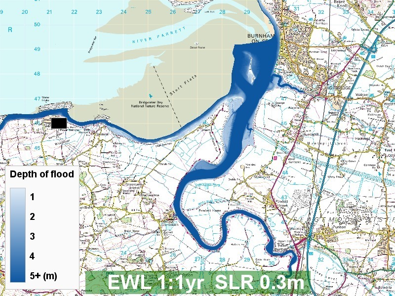
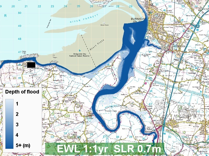
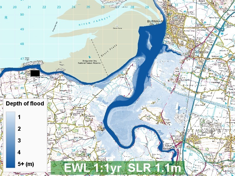
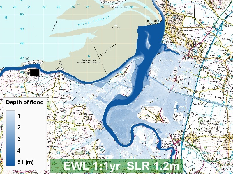
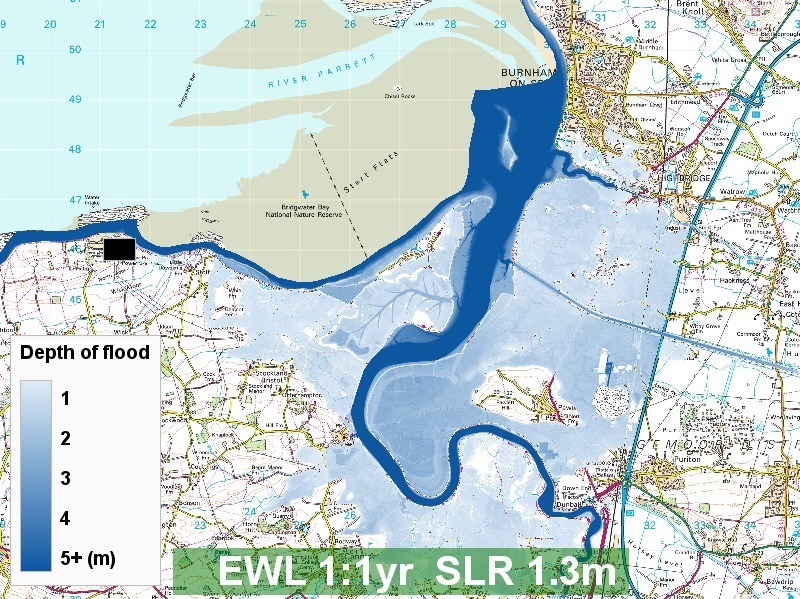
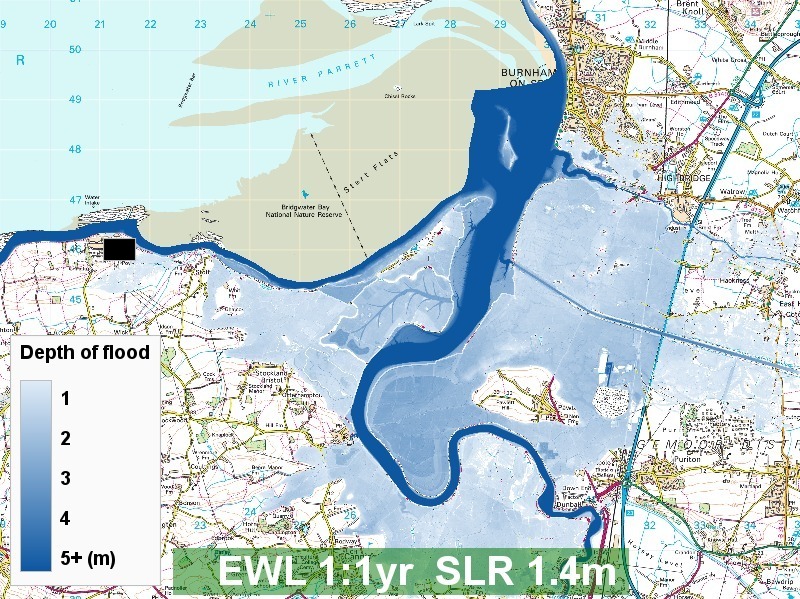
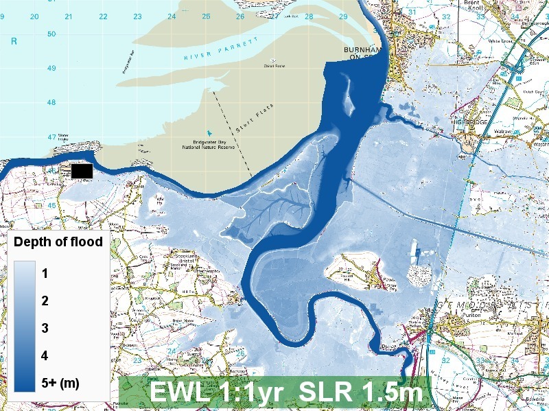
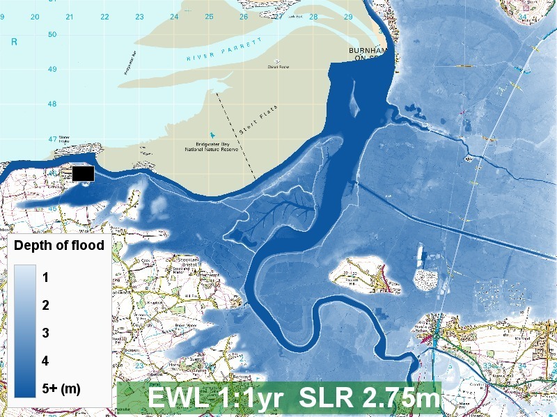
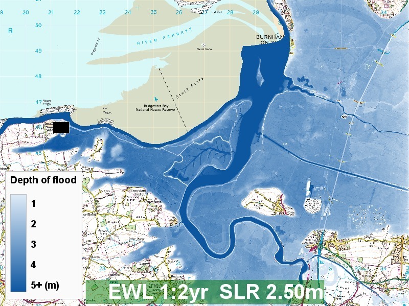
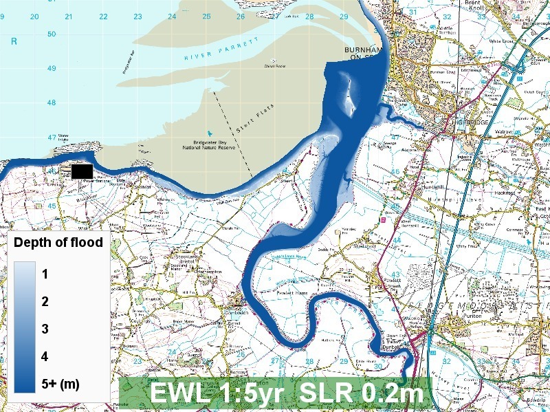
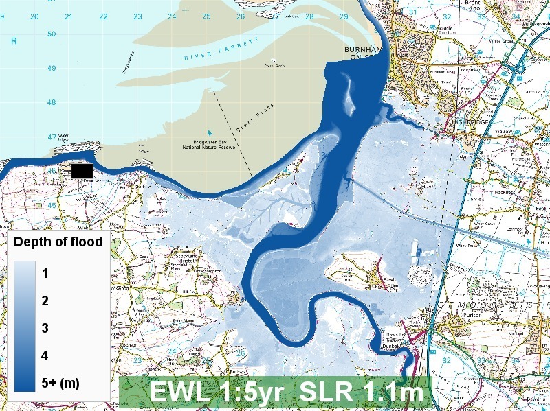
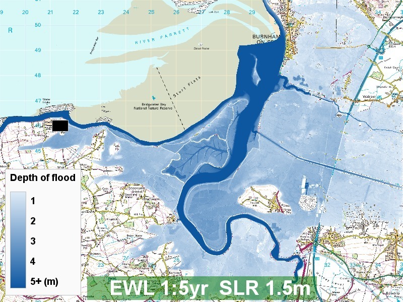
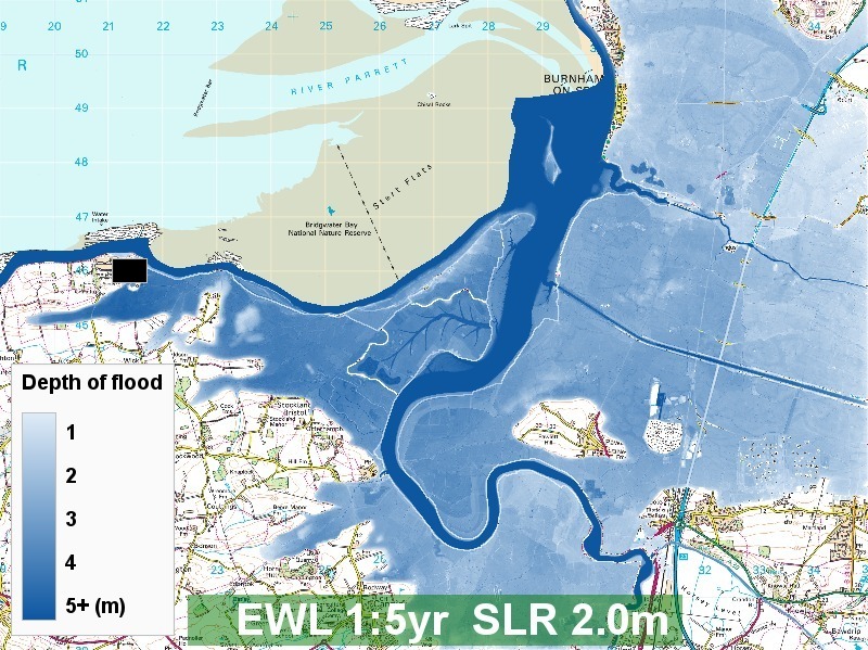
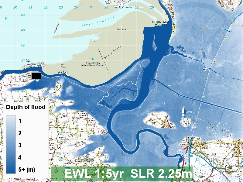
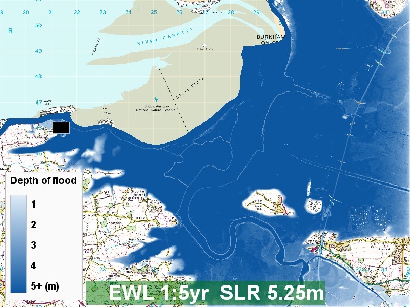
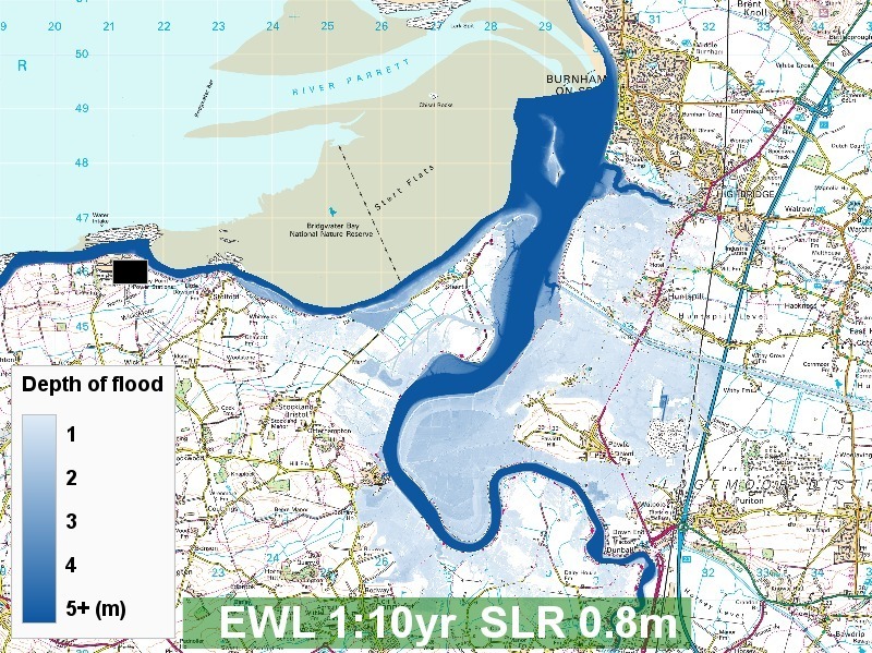
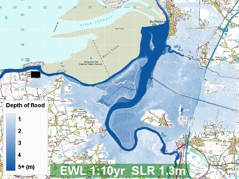
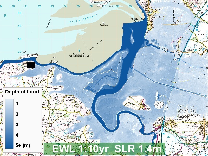
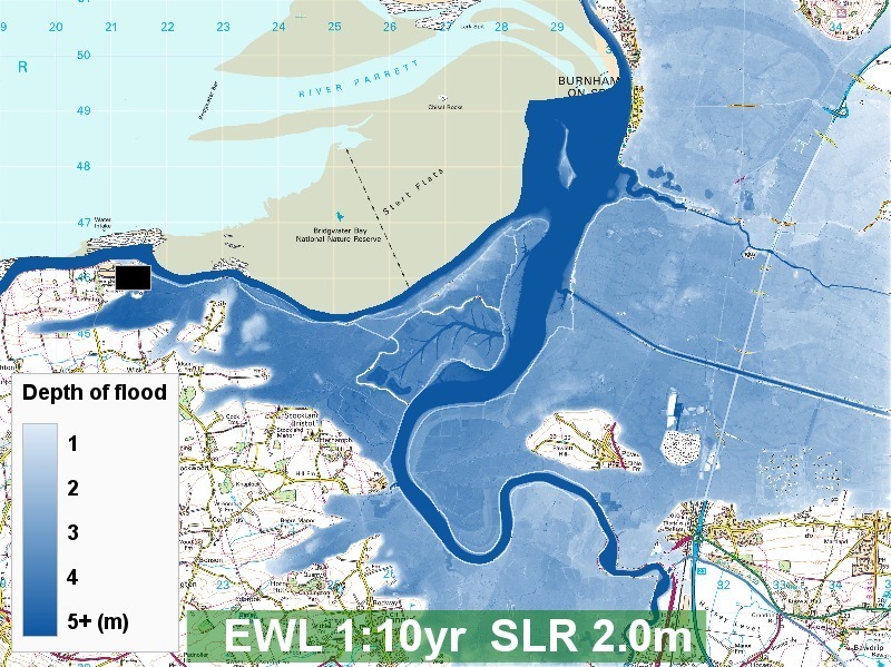
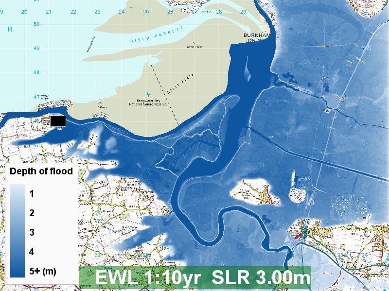
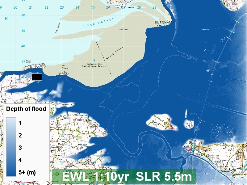
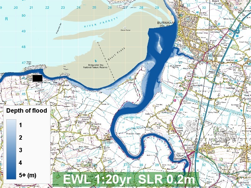
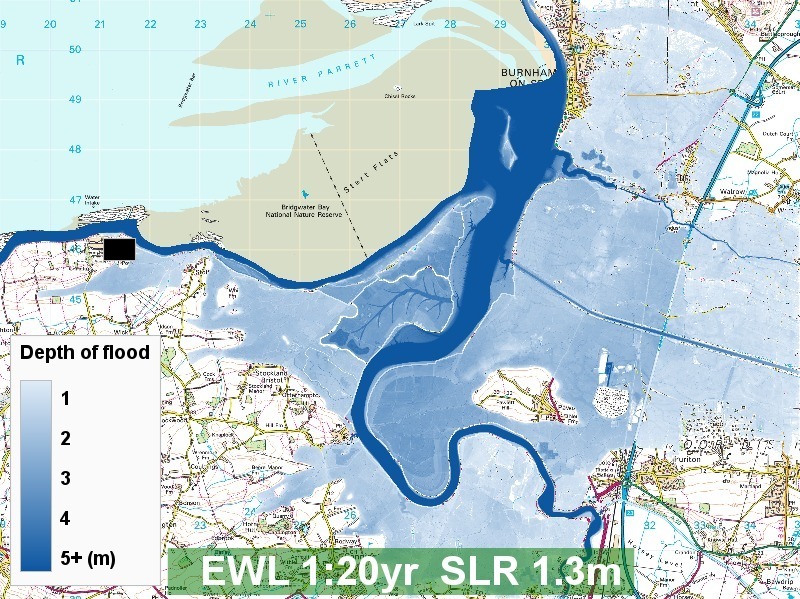
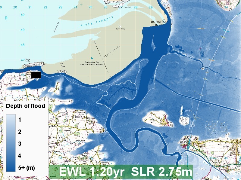
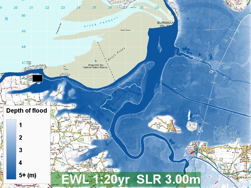
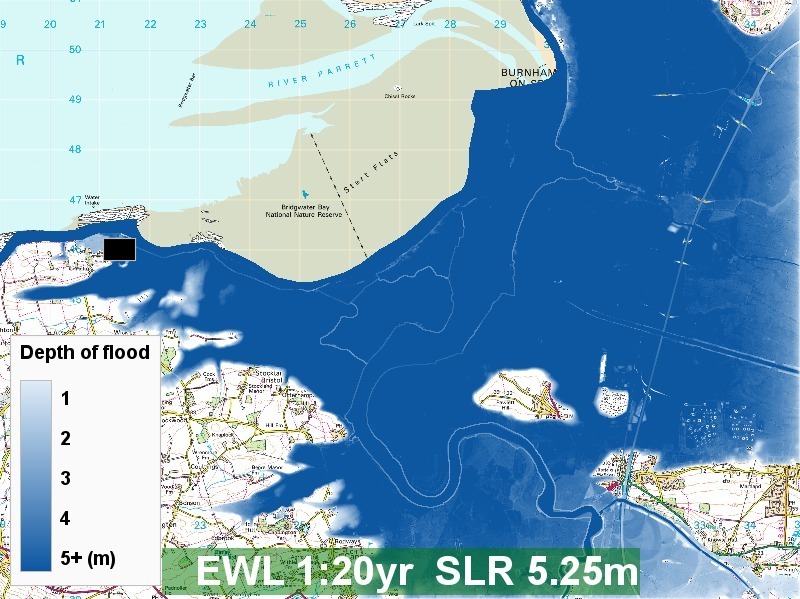
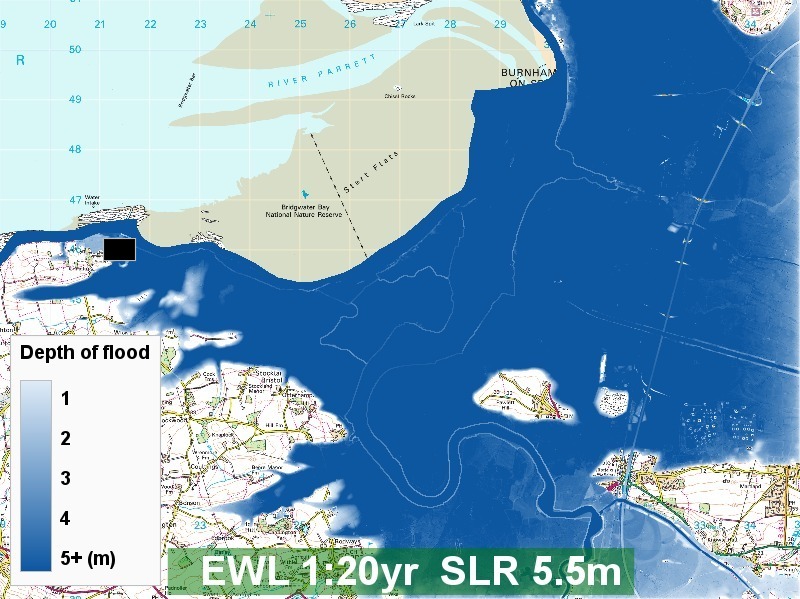
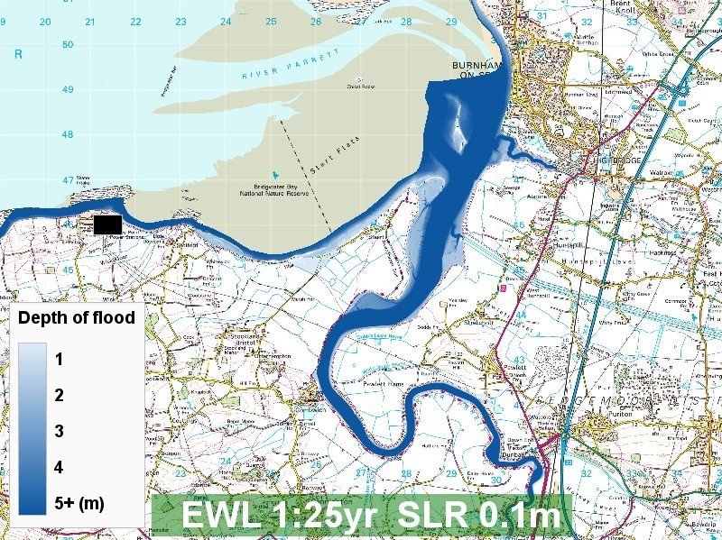
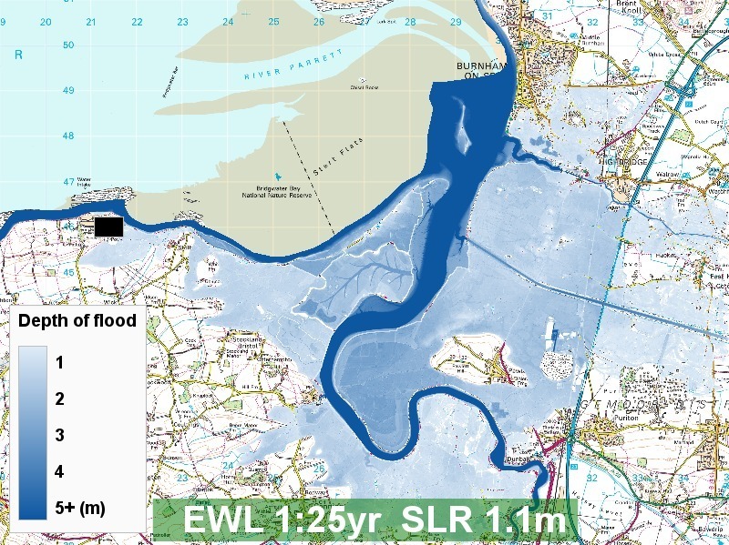
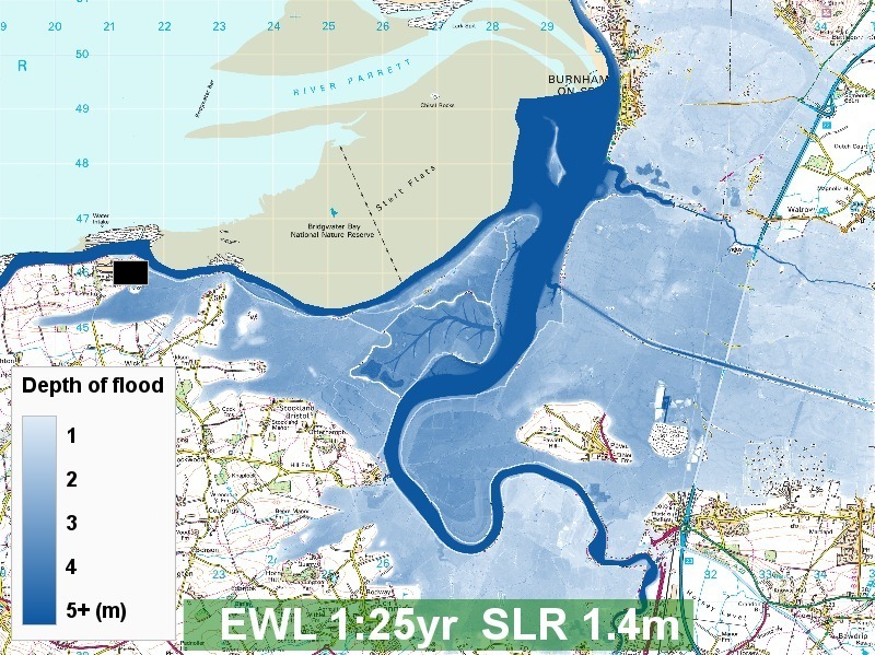
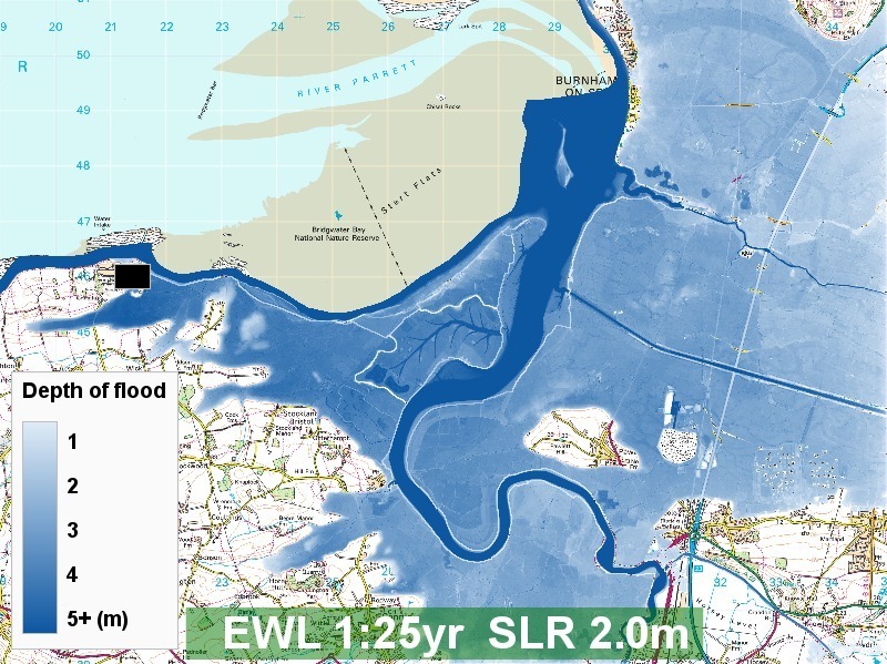
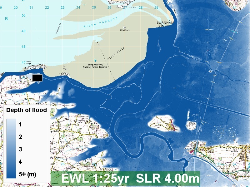
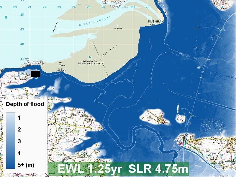
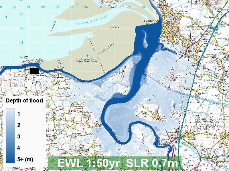
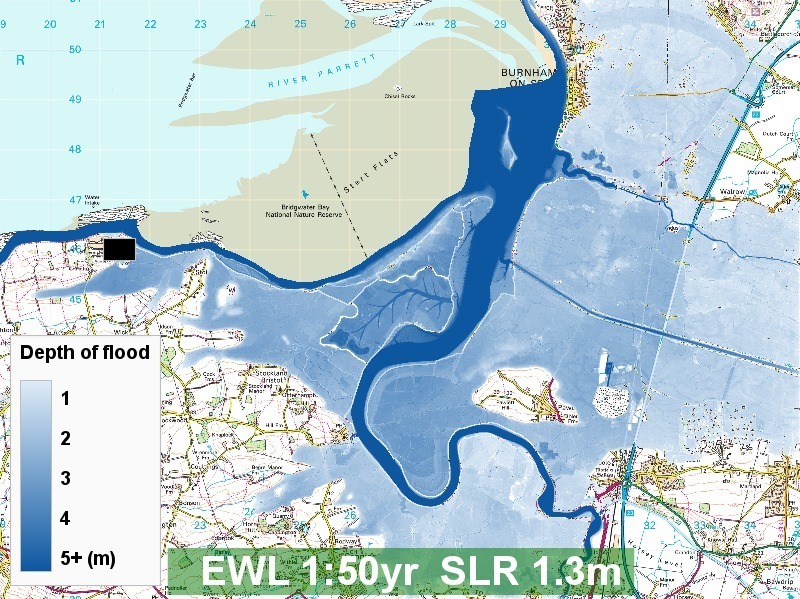
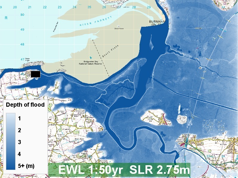
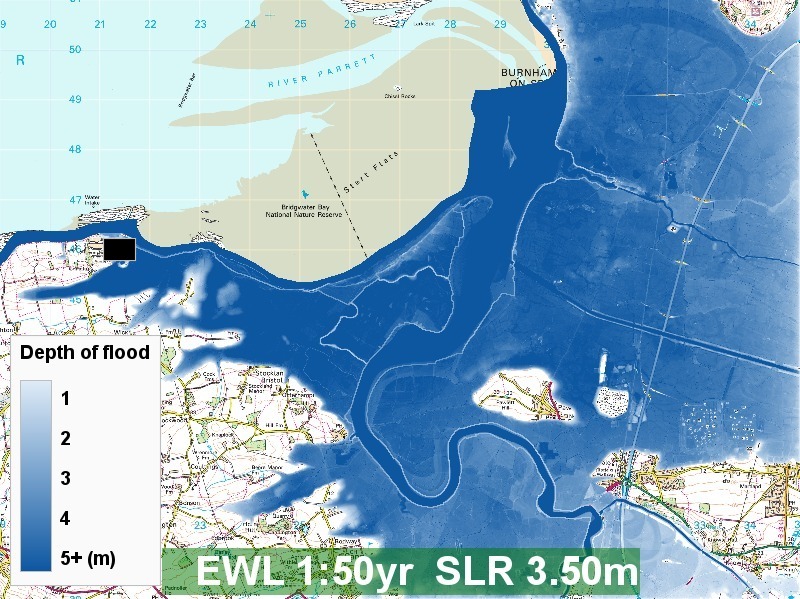
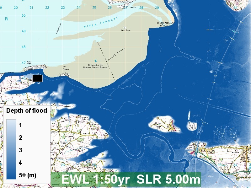
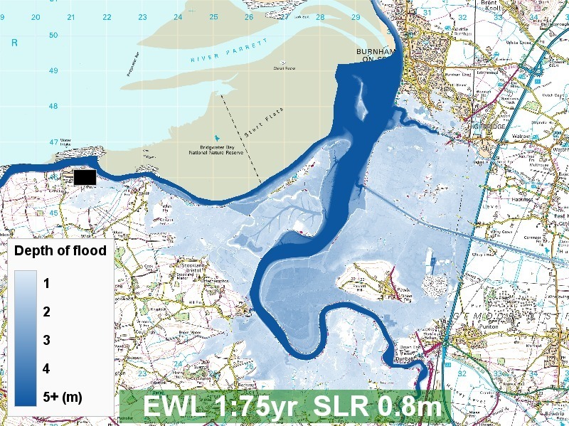
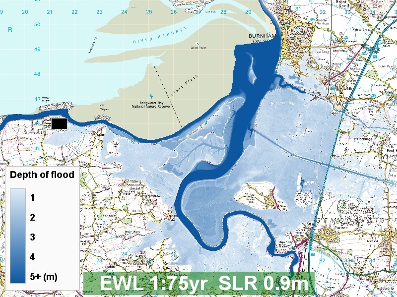
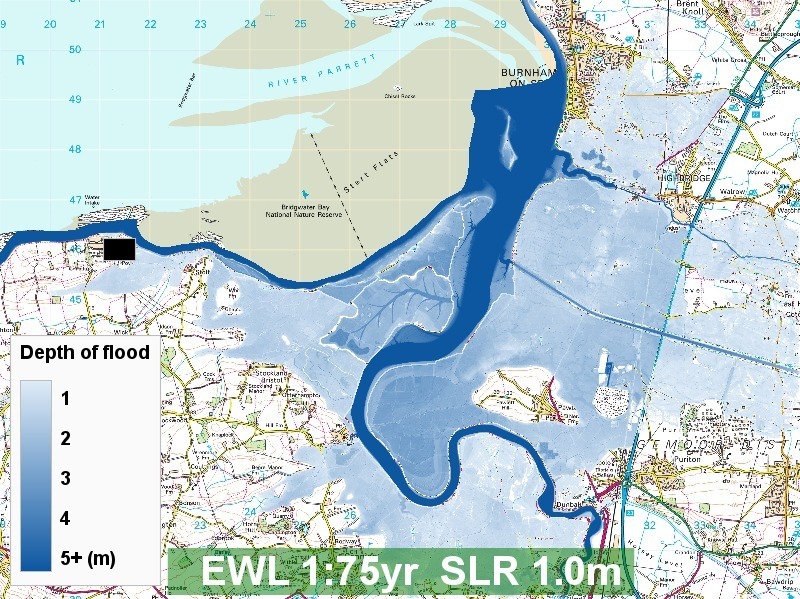
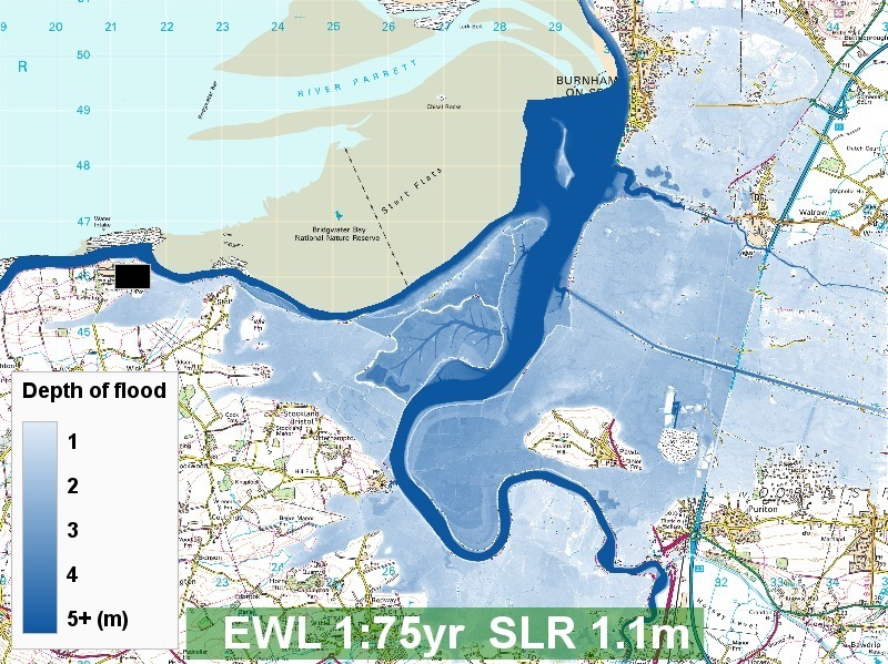
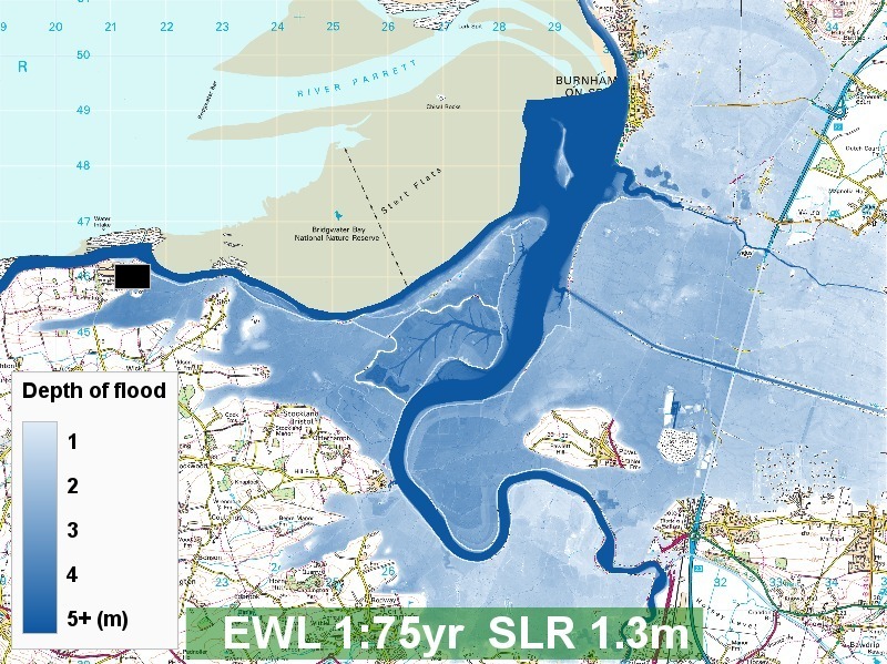
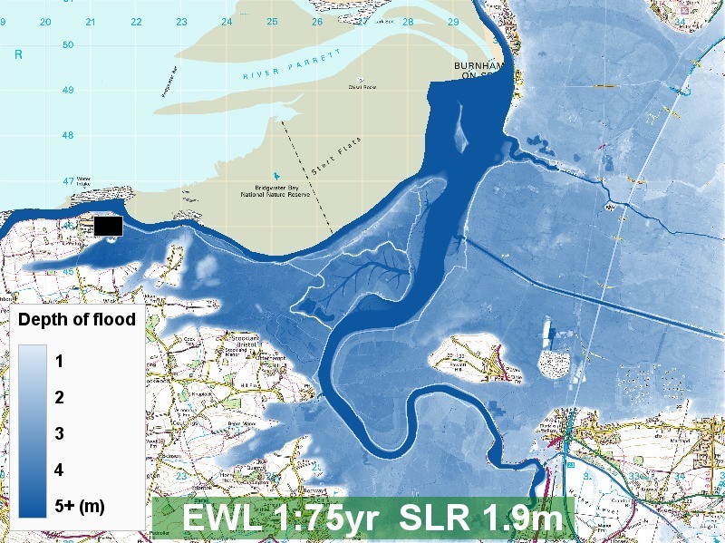
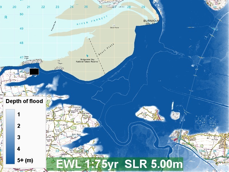
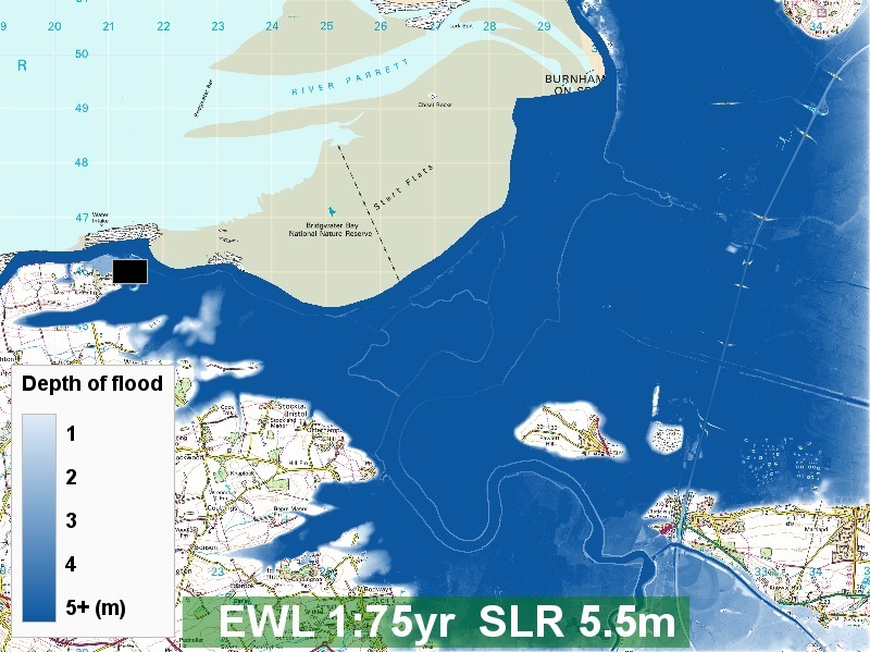
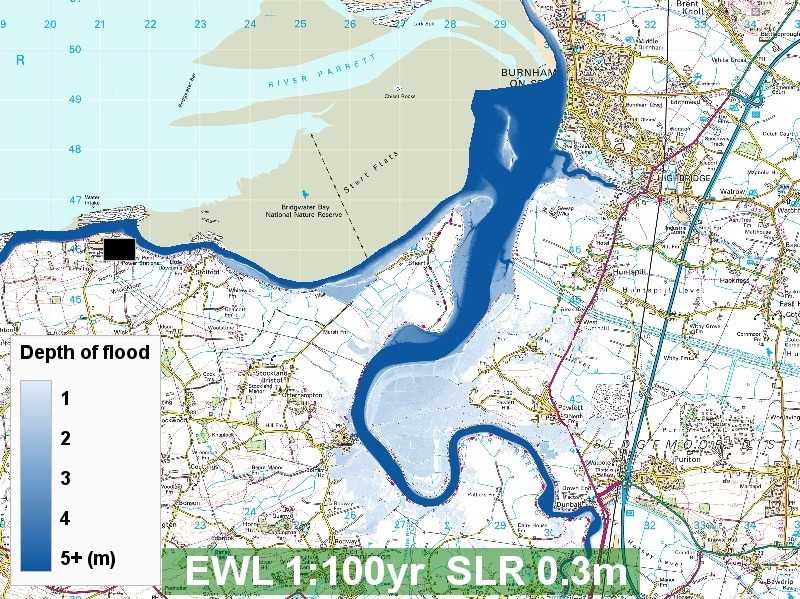
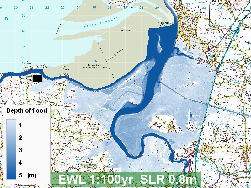
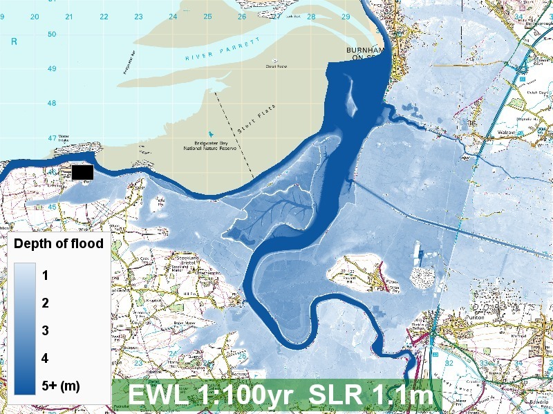
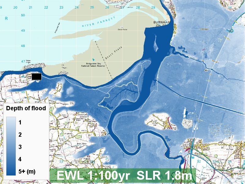
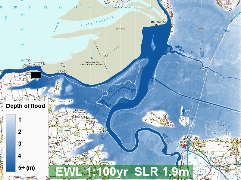
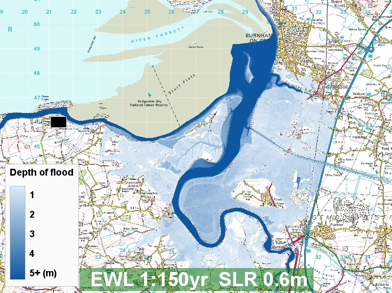
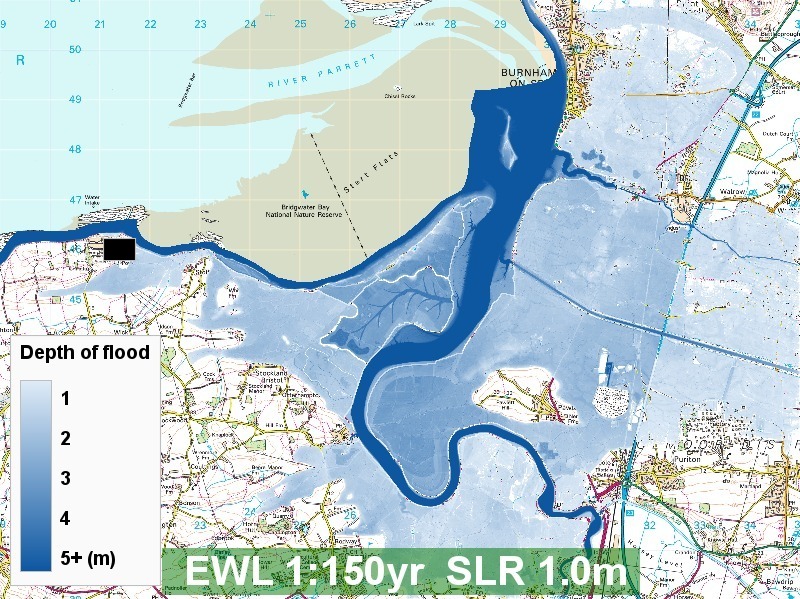
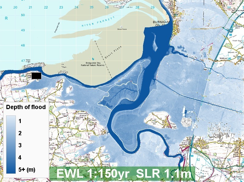
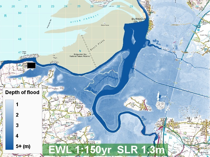
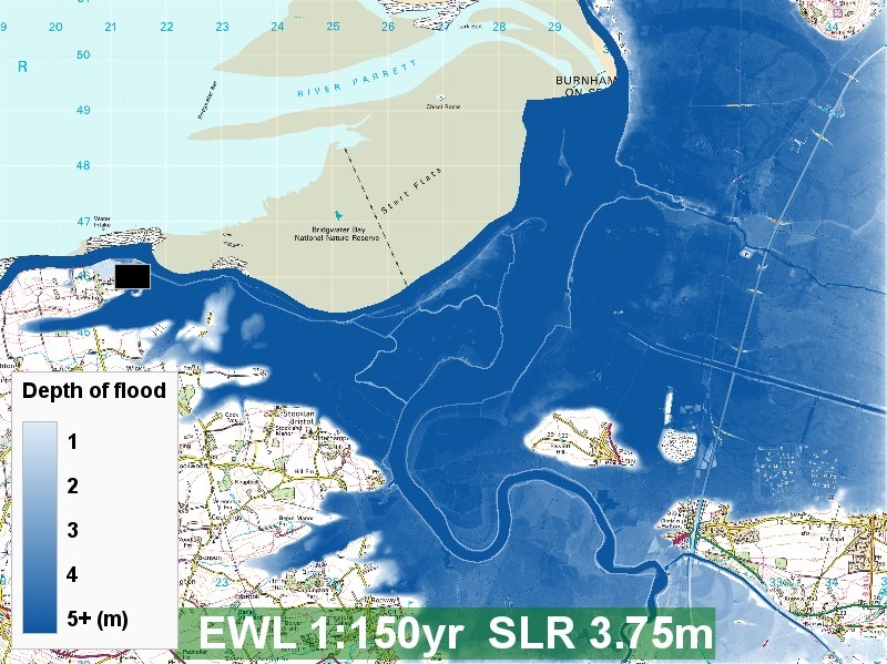
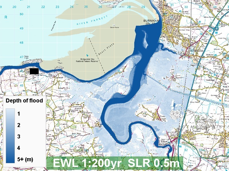
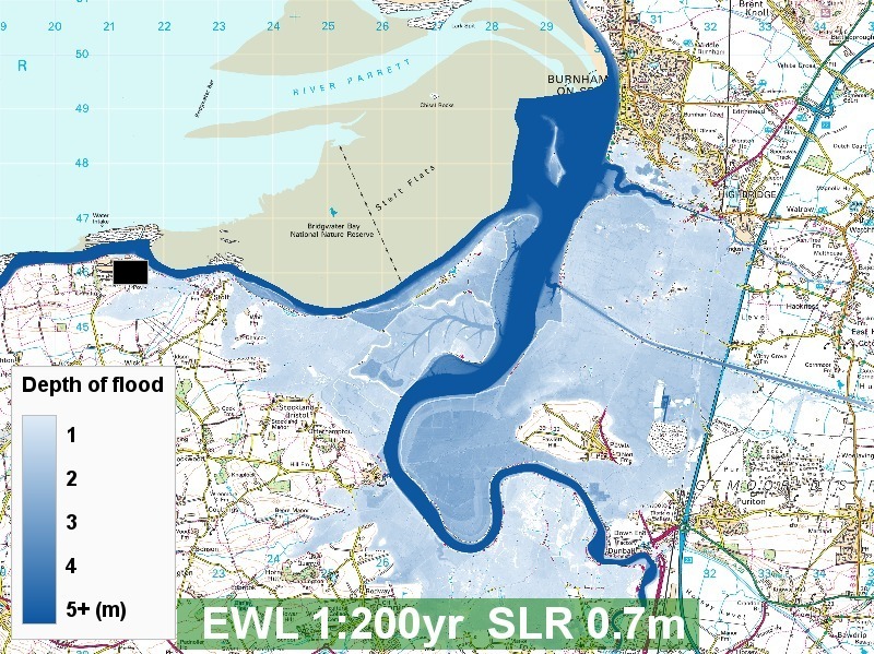
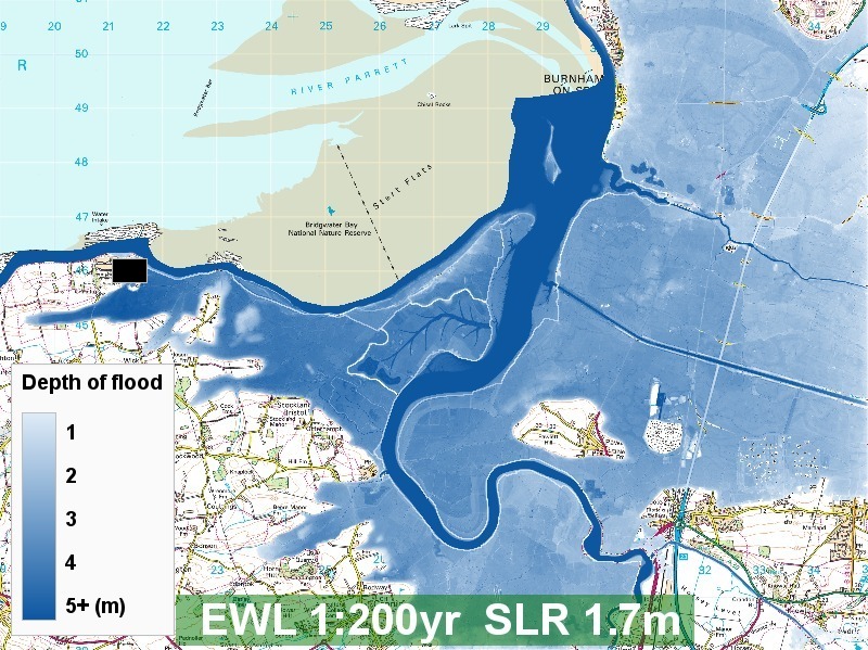
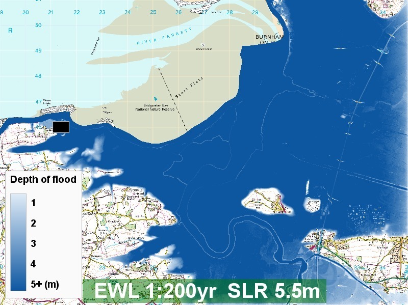
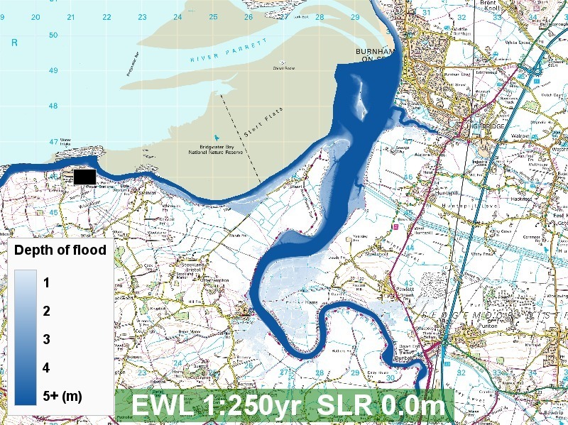
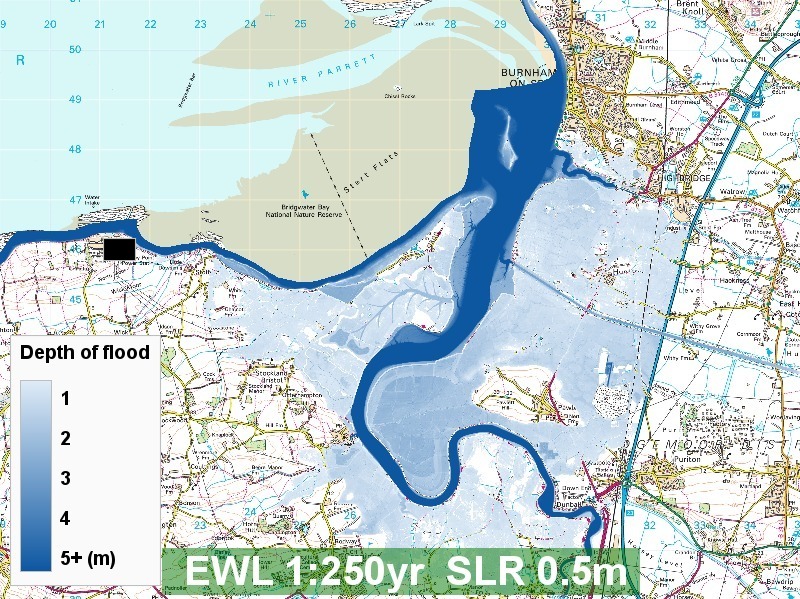
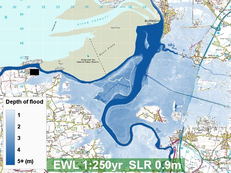
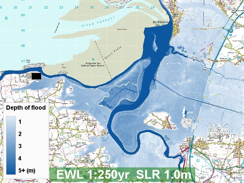
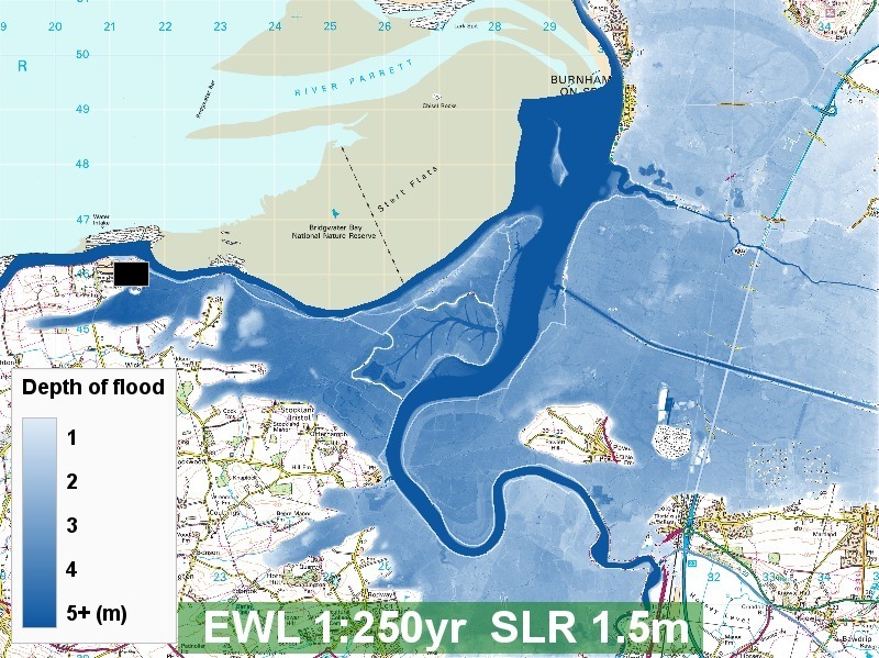
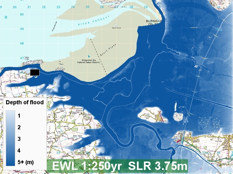
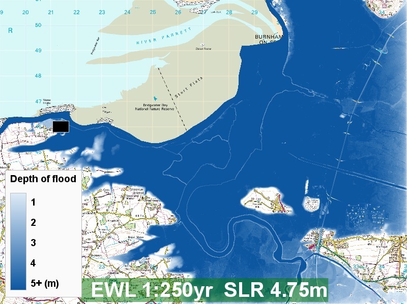
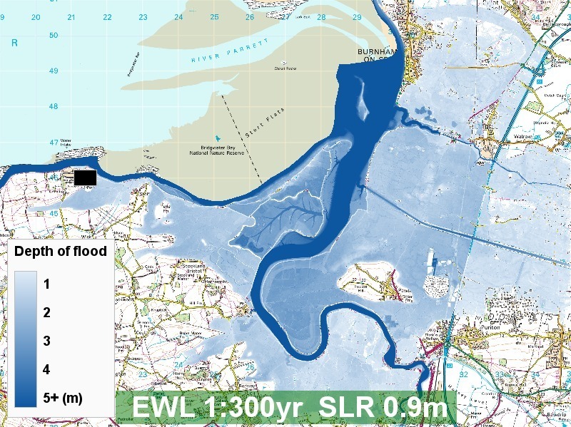
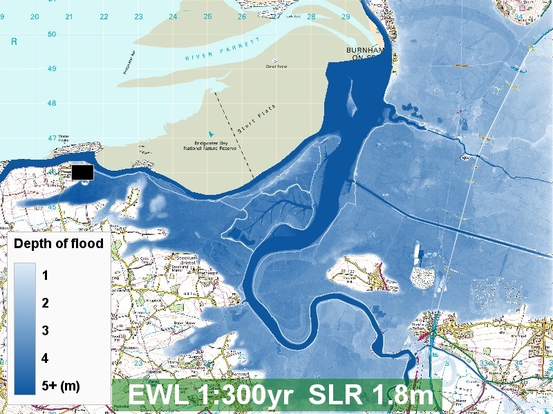
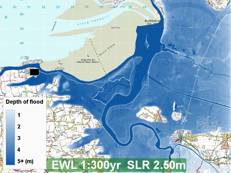
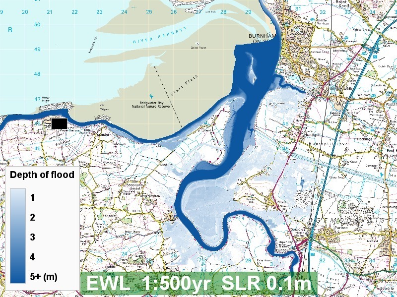
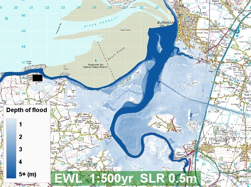
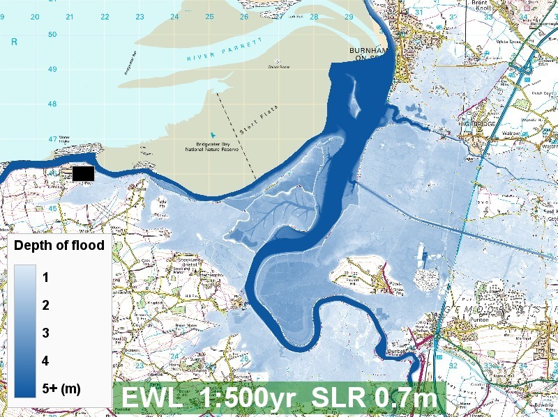
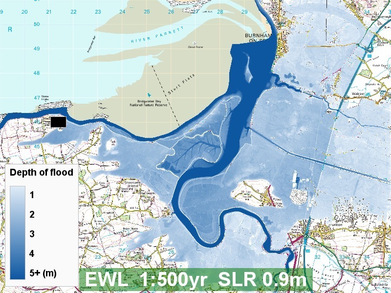
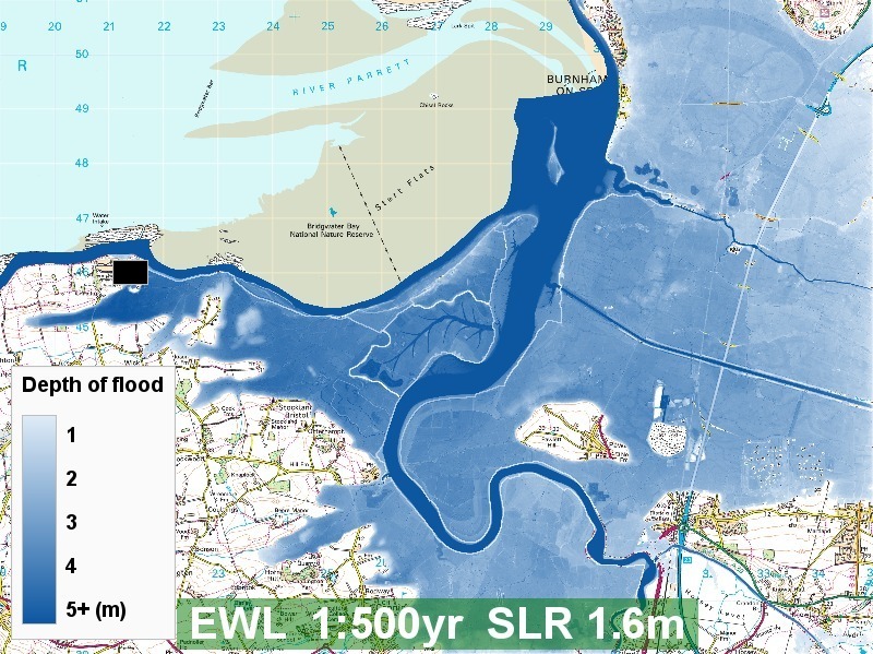
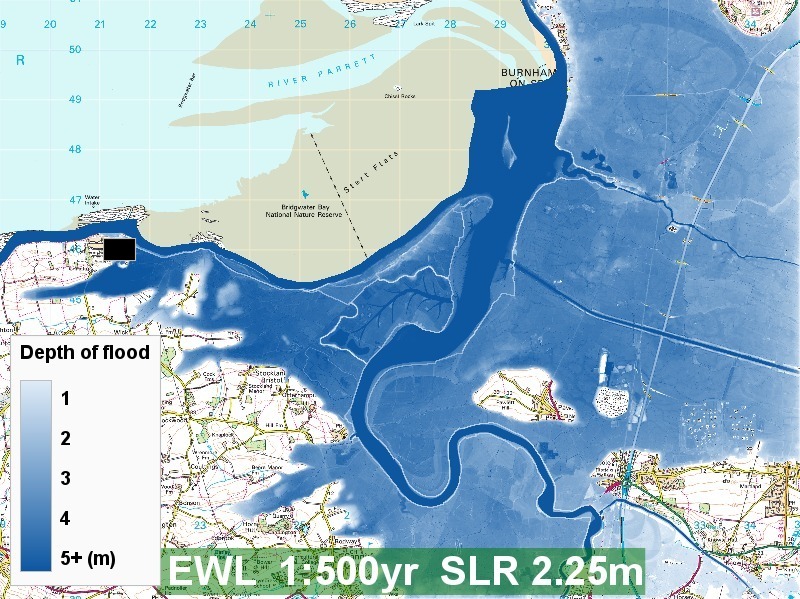
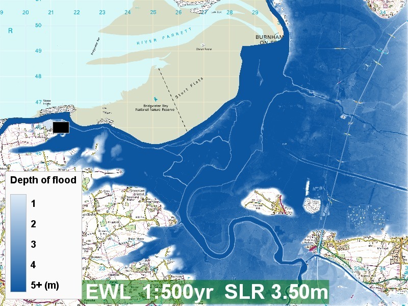
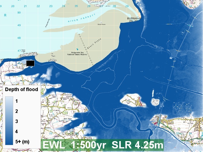
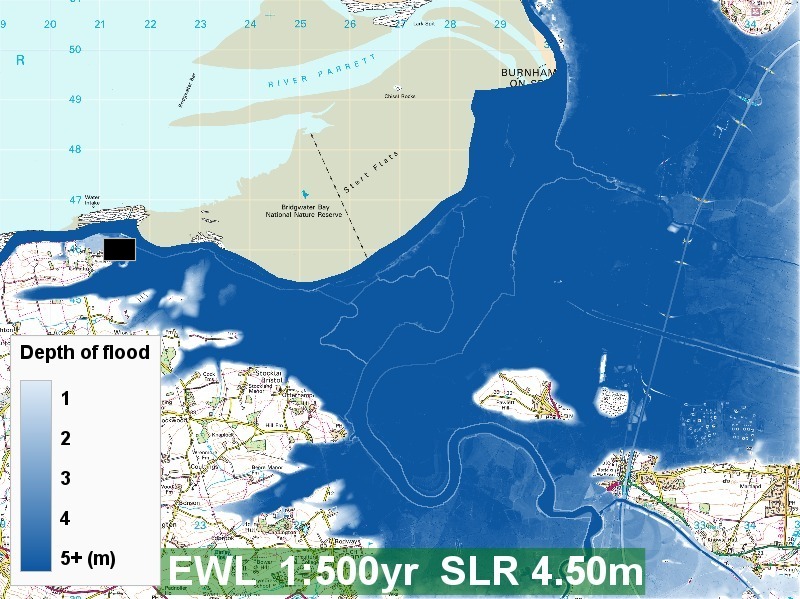
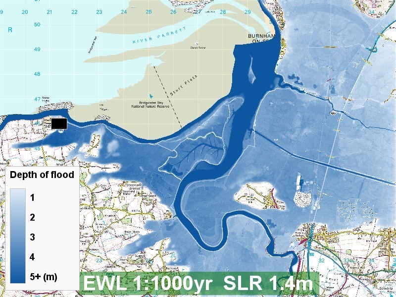
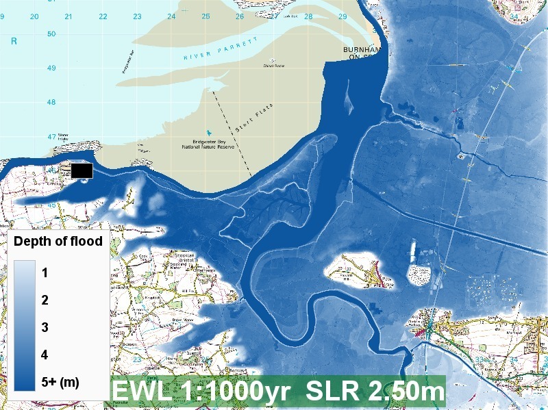
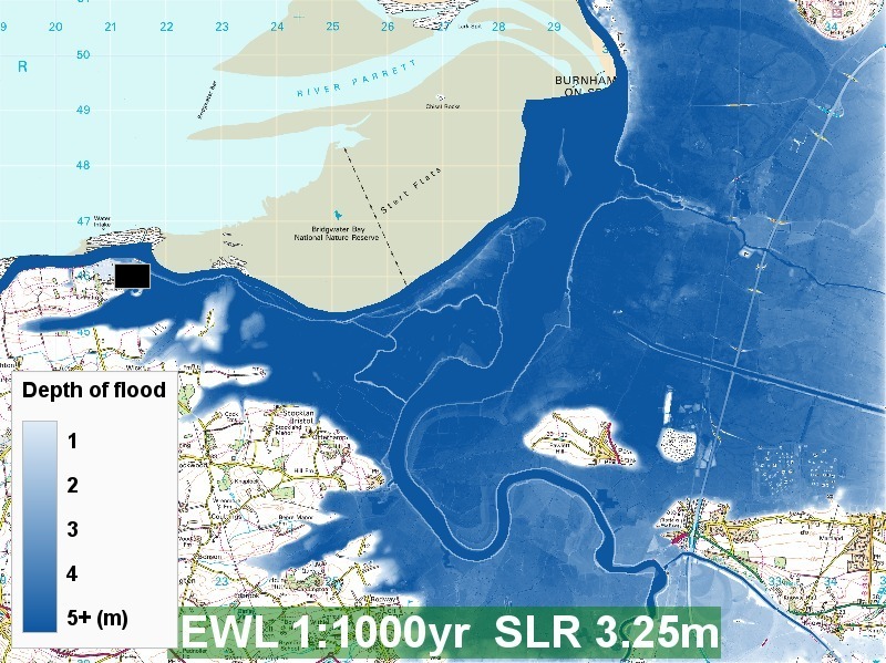
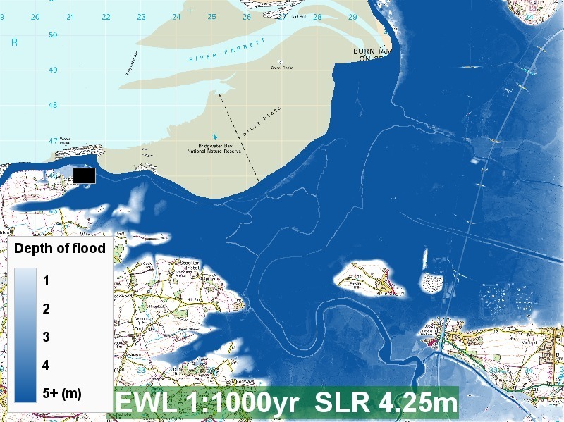
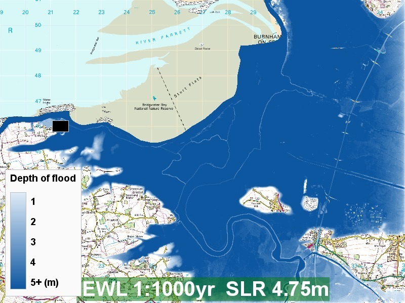
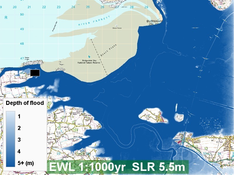
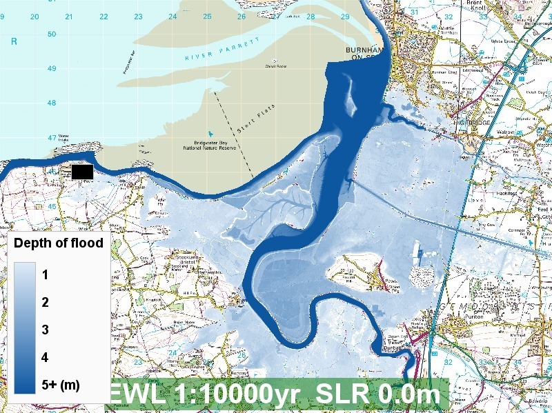
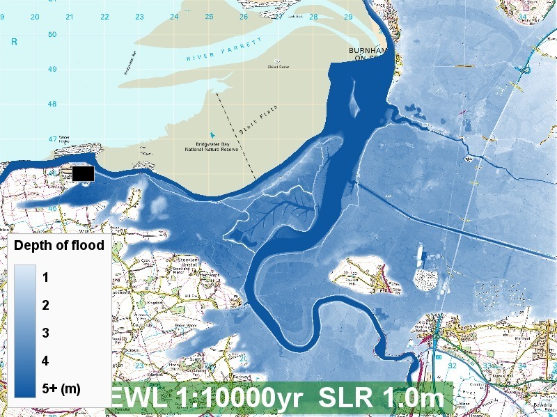
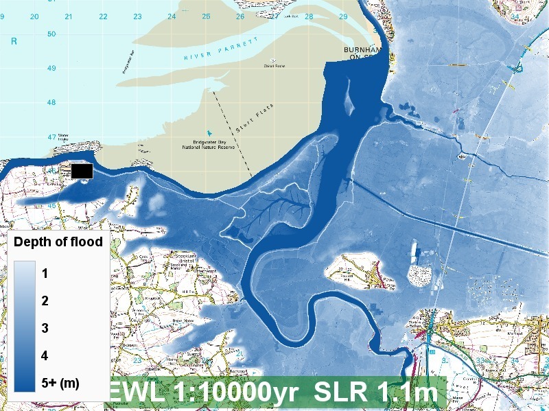
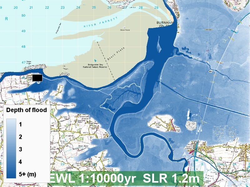
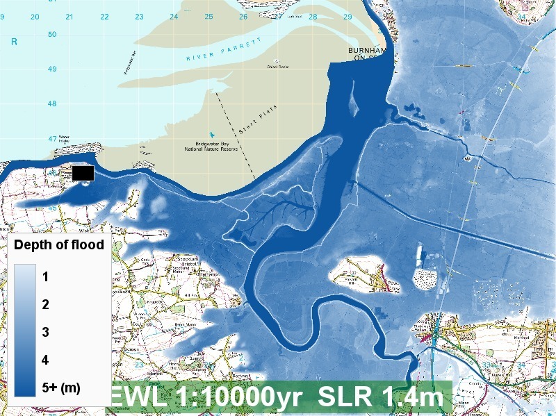
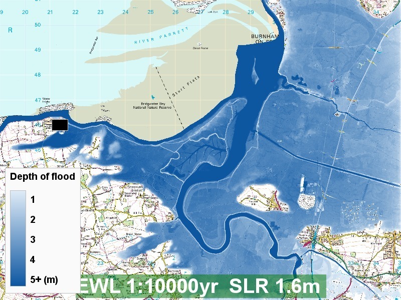
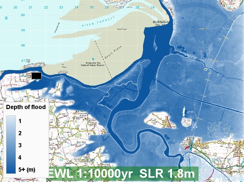
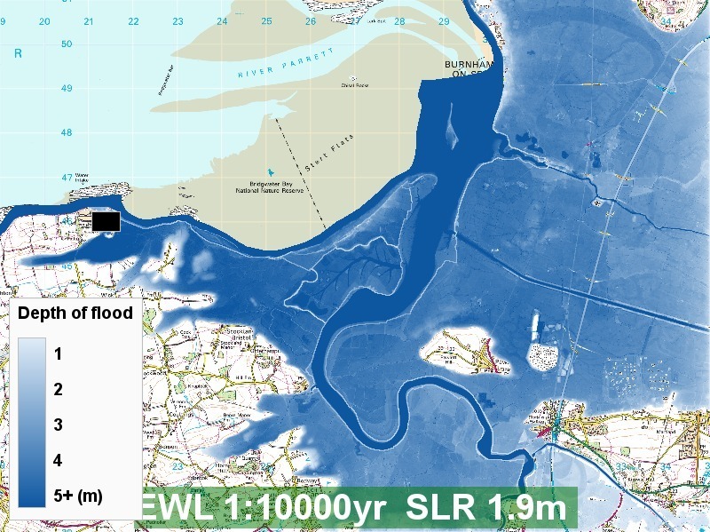
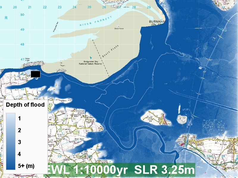
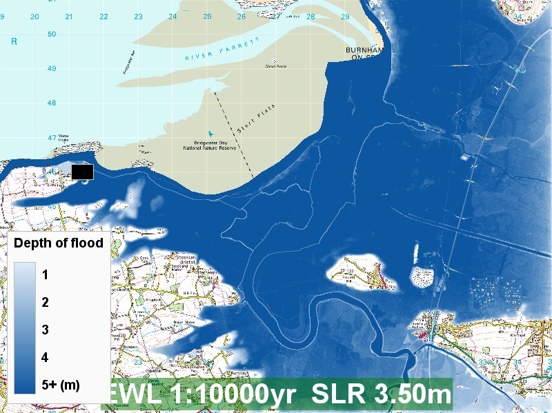
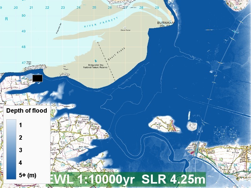
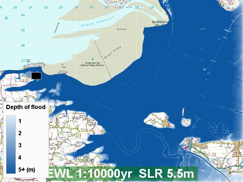