| Sellafield |
|
EWL 1:1 yr
LISFLOOD-FP model results for Sellafield model domain. The blanked out areas near to Sellafield and Drigg are covered by existing pre-operational and operational safety cases.
LISFLOOD-FP model results for Sellafield model domain. The blanked out areas near to Sellafield and Drigg are covered by existing pre-operational and operational safety cases.
LISFLOOD-FP model results for Sellafield model domain. The blanked out areas near to Sellafield and Drigg are covered by existing pre-operational and operational safety cases.
LISFLOOD-FP model results for Sellafield model domain. The blanked out areas near to Sellafield and Drigg are covered by existing pre-operational and operational safety cases.
LISFLOOD-FP model results for Sellafield model domain. The blanked out areas near to Sellafield and Drigg are covered by existing pre-operational and operational safety cases.
LISFLOOD-FP model results for Sellafield model domain. The blanked out areas near to Sellafield and Drigg are covered by existing pre-operational and operational safety cases.
LISFLOOD-FP model results for Sellafield model domain. The blanked out areas near to Sellafield and Drigg are covered by existing pre-operational and operational safety cases.
LISFLOOD-FP model results for Sellafield model domain. The blanked out areas near to Sellafield and Drigg are covered by existing pre-operational and operational safety cases.
LISFLOOD-FP model results for Sellafield model domain. The blanked out areas near to Sellafield and Drigg are covered by existing pre-operational and operational safety cases.
LISFLOOD-FP model results for Sellafield model domain. The blanked out areas near to Sellafield and Drigg are covered by existing pre-operational and operational safety cases.
LISFLOOD-FP model results for Sellafield model domain. The blanked out areas near to Sellafield and Drigg are covered by existing pre-operational and operational safety cases.
LISFLOOD-FP model results for Sellafield model domain. The blanked out areas near to Sellafield and Drigg are covered by existing pre-operational and operational safety cases.
LISFLOOD-FP model results for Sellafield model domain. The blanked out areas near to Sellafield and Drigg are covered by existing pre-operational and operational safety cases.
LISFLOOD-FP model results for Sellafield model domain. The blanked out areas near to Sellafield and Drigg are covered by existing pre-operational and operational safety cases.
LISFLOOD-FP model results for Sellafield model domain. The blanked out areas near to Sellafield and Drigg are covered by existing pre-operational and operational safety cases.
LISFLOOD-FP model results for Sellafield model domain. The blanked out areas near to Sellafield and Drigg are covered by existing pre-operational and operational safety cases.
LISFLOOD-FP model results for Sellafield model domain. The blanked out areas near to Sellafield and Drigg are covered by existing pre-operational and operational safety cases.
LISFLOOD-FP model results for Sellafield model domain. The blanked out areas near to Sellafield and Drigg are covered by existing pre-operational and operational safety cases.
LISFLOOD-FP model results for Sellafield model domain. The blanked out areas near to Sellafield and Drigg are covered by existing pre-operational and operational safety cases.
LISFLOOD-FP model results for Sellafield model domain. The blanked out areas near to Sellafield and Drigg are covered by existing pre-operational and operational safety cases.
LISFLOOD-FP model results for Sellafield model domain. The blanked out areas near to Sellafield and Drigg are covered by existing pre-operational and operational safety cases.
LISFLOOD-FP model results for Sellafield model domain. The blanked out areas near to Sellafield and Drigg are covered by existing pre-operational and operational safety cases.
LISFLOOD-FP model results for Sellafield model domain. The blanked out areas near to Sellafield and Drigg are covered by existing pre-operational and operational safety cases.
LISFLOOD-FP model results for Sellafield model domain. The blanked out areas near to Sellafield and Drigg are covered by existing pre-operational and operational safety cases.
LISFLOOD-FP model results for Sellafield model domain. The blanked out areas near to Sellafield and Drigg are covered by existing pre-operational and operational safety cases.
LISFLOOD-FP model results for Sellafield model domain. The blanked out areas near to Sellafield and Drigg are covered by existing pre-operational and operational safety cases.
LISFLOOD-FP model results for Sellafield model domain. The blanked out areas near to Sellafield and Drigg are covered by existing pre-operational and operational safety cases.
LISFLOOD-FP model results for Sellafield model domain. The blanked out areas near to Sellafield and Drigg are covered by existing pre-operational and operational safety cases.
LISFLOOD-FP model results for Sellafield model domain. The blanked out areas near to Sellafield and Drigg are covered by existing pre-operational and operational safety cases.
LISFLOOD-FP model results for Sellafield model domain. The blanked out areas near to Sellafield and Drigg are covered by existing pre-operational and operational safety cases.
LISFLOOD-FP model results for Sellafield model domain. The blanked out areas near to Sellafield and Drigg are covered by existing pre-operational and operational safety cases.
LISFLOOD-FP model results for Sellafield model domain. The blanked out areas near to Sellafield and Drigg are covered by existing pre-operational and operational safety cases.
LISFLOOD-FP model results for Sellafield model domain. The blanked out areas near to Sellafield and Drigg are covered by existing pre-operational and operational safety cases.
LISFLOOD-FP model results for Sellafield model domain. The blanked out areas near to Sellafield and Drigg are covered by existing pre-operational and operational safety cases.
LISFLOOD-FP model results for Sellafield model domain. The blanked out areas near to Sellafield and Drigg are covered by existing pre-operational and operational safety cases.
EWL 1:2 yr
LISFLOOD-FP model results for Sellafield model domain. The blanked out areas near to Sellafield and Drigg are covered by existing pre-operational and operational safety cases.
LISFLOOD-FP model results for Sellafield model domain. The blanked out areas near to Sellafield and Drigg are covered by existing pre-operational and operational safety cases.
LISFLOOD-FP model results for Sellafield model domain. The blanked out areas near to Sellafield and Drigg are covered by existing pre-operational and operational safety cases.
LISFLOOD-FP model results for Sellafield model domain. The blanked out areas near to Sellafield and Drigg are covered by existing pre-operational and operational safety cases.
LISFLOOD-FP model results for Sellafield model domain. The blanked out areas near to Sellafield and Drigg are covered by existing pre-operational and operational safety cases.
LISFLOOD-FP model results for Sellafield model domain. The blanked out areas near to Sellafield and Drigg are covered by existing pre-operational and operational safety cases.
LISFLOOD-FP model results for Sellafield model domain. The blanked out areas near to Sellafield and Drigg are covered by existing pre-operational and operational safety cases.
LISFLOOD-FP model results for Sellafield model domain. The blanked out areas near to Sellafield and Drigg are covered by existing pre-operational and operational safety cases.
LISFLOOD-FP model results for Sellafield model domain. The blanked out areas near to Sellafield and Drigg are covered by existing pre-operational and operational safety cases.
LISFLOOD-FP model results for Sellafield model domain. The blanked out areas near to Sellafield and Drigg are covered by existing pre-operational and operational safety cases.
LISFLOOD-FP model results for Sellafield model domain. The blanked out areas near to Sellafield and Drigg are covered by existing pre-operational and operational safety cases.
LISFLOOD-FP model results for Sellafield model domain. The blanked out areas near to Sellafield and Drigg are covered by existing pre-operational and operational safety cases.
LISFLOOD-FP model results for Sellafield model domain. The blanked out areas near to Sellafield and Drigg are covered by existing pre-operational and operational safety cases.
LISFLOOD-FP model results for Sellafield model domain. The blanked out areas near to Sellafield and Drigg are covered by existing pre-operational and operational safety cases.
LISFLOOD-FP model results for Sellafield model domain. The blanked out areas near to Sellafield and Drigg are covered by existing pre-operational and operational safety cases.
LISFLOOD-FP model results for Sellafield model domain. The blanked out areas near to Sellafield and Drigg are covered by existing pre-operational and operational safety cases.
LISFLOOD-FP model results for Sellafield model domain. The blanked out areas near to Sellafield and Drigg are covered by existing pre-operational and operational safety cases.
LISFLOOD-FP model results for Sellafield model domain. The blanked out areas near to Sellafield and Drigg are covered by existing pre-operational and operational safety cases.
LISFLOOD-FP model results for Sellafield model domain. The blanked out areas near to Sellafield and Drigg are covered by existing pre-operational and operational safety cases.
LISFLOOD-FP model results for Sellafield model domain. The blanked out areas near to Sellafield and Drigg are covered by existing pre-operational and operational safety cases.
LISFLOOD-FP model results for Sellafield model domain. The blanked out areas near to Sellafield and Drigg are covered by existing pre-operational and operational safety cases.
LISFLOOD-FP model results for Sellafield model domain. The blanked out areas near to Sellafield and Drigg are covered by existing pre-operational and operational safety cases.
LISFLOOD-FP model results for Sellafield model domain. The blanked out areas near to Sellafield and Drigg are covered by existing pre-operational and operational safety cases.
LISFLOOD-FP model results for Sellafield model domain. The blanked out areas near to Sellafield and Drigg are covered by existing pre-operational and operational safety cases.
LISFLOOD-FP model results for Sellafield model domain. The blanked out areas near to Sellafield and Drigg are covered by existing pre-operational and operational safety cases.
LISFLOOD-FP model results for Sellafield model domain. The blanked out areas near to Sellafield and Drigg are covered by existing pre-operational and operational safety cases.
LISFLOOD-FP model results for Sellafield model domain. The blanked out areas near to Sellafield and Drigg are covered by existing pre-operational and operational safety cases.
LISFLOOD-FP model results for Sellafield model domain. The blanked out areas near to Sellafield and Drigg are covered by existing pre-operational and operational safety cases.
LISFLOOD-FP model results for Sellafield model domain. The blanked out areas near to Sellafield and Drigg are covered by existing pre-operational and operational safety cases.
LISFLOOD-FP model results for Sellafield model domain. The blanked out areas near to Sellafield and Drigg are covered by existing pre-operational and operational safety cases.
LISFLOOD-FP model results for Sellafield model domain. The blanked out areas near to Sellafield and Drigg are covered by existing pre-operational and operational safety cases.
LISFLOOD-FP model results for Sellafield model domain. The blanked out areas near to Sellafield and Drigg are covered by existing pre-operational and operational safety cases.
LISFLOOD-FP model results for Sellafield model domain. The blanked out areas near to Sellafield and Drigg are covered by existing pre-operational and operational safety cases.
LISFLOOD-FP model results for Sellafield model domain. The blanked out areas near to Sellafield and Drigg are covered by existing pre-operational and operational safety cases.
LISFLOOD-FP model results for Sellafield model domain. The blanked out areas near to Sellafield and Drigg are covered by existing pre-operational and operational safety cases.
EWL 1:5 yr
LISFLOOD-FP model results for Sellafield model domain. The blanked out areas near to Sellafield and Drigg are covered by existing pre-operational and operational safety cases.
LISFLOOD-FP model results for Sellafield model domain. The blanked out areas near to Sellafield and Drigg are covered by existing pre-operational and operational safety cases.
LISFLOOD-FP model results for Sellafield model domain. The blanked out areas near to Sellafield and Drigg are covered by existing pre-operational and operational safety cases.
LISFLOOD-FP model results for Sellafield model domain. The blanked out areas near to Sellafield and Drigg are covered by existing pre-operational and operational safety cases.
LISFLOOD-FP model results for Sellafield model domain. The blanked out areas near to Sellafield and Drigg are covered by existing pre-operational and operational safety cases.
LISFLOOD-FP model results for Sellafield model domain. The blanked out areas near to Sellafield and Drigg are covered by existing pre-operational and operational safety cases.
LISFLOOD-FP model results for Sellafield model domain. The blanked out areas near to Sellafield and Drigg are covered by existing pre-operational and operational safety cases.
LISFLOOD-FP model results for Sellafield model domain. The blanked out areas near to Sellafield and Drigg are covered by existing pre-operational and operational safety cases.
LISFLOOD-FP model results for Sellafield model domain. The blanked out areas near to Sellafield and Drigg are covered by existing pre-operational and operational safety cases.
LISFLOOD-FP model results for Sellafield model domain. The blanked out areas near to Sellafield and Drigg are covered by existing pre-operational and operational safety cases.
LISFLOOD-FP model results for Sellafield model domain. The blanked out areas near to Sellafield and Drigg are covered by existing pre-operational and operational safety cases.
LISFLOOD-FP model results for Sellafield model domain. The blanked out areas near to Sellafield and Drigg are covered by existing pre-operational and operational safety cases.
LISFLOOD-FP model results for Sellafield model domain. The blanked out areas near to Sellafield and Drigg are covered by existing pre-operational and operational safety cases.
LISFLOOD-FP model results for Sellafield model domain. The blanked out areas near to Sellafield and Drigg are covered by existing pre-operational and operational safety cases.
LISFLOOD-FP model results for Sellafield model domain. The blanked out areas near to Sellafield and Drigg are covered by existing pre-operational and operational safety cases.
LISFLOOD-FP model results for Sellafield model domain. The blanked out areas near to Sellafield and Drigg are covered by existing pre-operational and operational safety cases.
LISFLOOD-FP model results for Sellafield model domain. The blanked out areas near to Sellafield and Drigg are covered by existing pre-operational and operational safety cases.
LISFLOOD-FP model results for Sellafield model domain. The blanked out areas near to Sellafield and Drigg are covered by existing pre-operational and operational safety cases.
LISFLOOD-FP model results for Sellafield model domain. The blanked out areas near to Sellafield and Drigg are covered by existing pre-operational and operational safety cases.
LISFLOOD-FP model results for Sellafield model domain. The blanked out areas near to Sellafield and Drigg are covered by existing pre-operational and operational safety cases.
LISFLOOD-FP model results for Sellafield model domain. The blanked out areas near to Sellafield and Drigg are covered by existing pre-operational and operational safety cases.
LISFLOOD-FP model results for Sellafield model domain. The blanked out areas near to Sellafield and Drigg are covered by existing pre-operational and operational safety cases.
LISFLOOD-FP model results for Sellafield model domain. The blanked out areas near to Sellafield and Drigg are covered by existing pre-operational and operational safety cases.
LISFLOOD-FP model results for Sellafield model domain. The blanked out areas near to Sellafield and Drigg are covered by existing pre-operational and operational safety cases.
LISFLOOD-FP model results for Sellafield model domain. The blanked out areas near to Sellafield and Drigg are covered by existing pre-operational and operational safety cases.
LISFLOOD-FP model results for Sellafield model domain. The blanked out areas near to Sellafield and Drigg are covered by existing pre-operational and operational safety cases.
LISFLOOD-FP model results for Sellafield model domain. The blanked out areas near to Sellafield and Drigg are covered by existing pre-operational and operational safety cases.
LISFLOOD-FP model results for Sellafield model domain. The blanked out areas near to Sellafield and Drigg are covered by existing pre-operational and operational safety cases.
LISFLOOD-FP model results for Sellafield model domain. The blanked out areas near to Sellafield and Drigg are covered by existing pre-operational and operational safety cases.
LISFLOOD-FP model results for Sellafield model domain. The blanked out areas near to Sellafield and Drigg are covered by existing pre-operational and operational safety cases.
LISFLOOD-FP model results for Sellafield model domain. The blanked out areas near to Sellafield and Drigg are covered by existing pre-operational and operational safety cases.
LISFLOOD-FP model results for Sellafield model domain. The blanked out areas near to Sellafield and Drigg are covered by existing pre-operational and operational safety cases.
LISFLOOD-FP model results for Sellafield model domain. The blanked out areas near to Sellafield and Drigg are covered by existing pre-operational and operational safety cases.
LISFLOOD-FP model results for Sellafield model domain. The blanked out areas near to Sellafield and Drigg are covered by existing pre-operational and operational safety cases.
LISFLOOD-FP model results for Sellafield model domain. The blanked out areas near to Sellafield and Drigg are covered by existing pre-operational and operational safety cases.
EWL 1:10 yr
LISFLOOD-FP model results for Sellafield model domain. The blanked out areas near to Sellafield and Drigg are covered by existing pre-operational and operational safety cases.
LISFLOOD-FP model results for Sellafield model domain. The blanked out areas near to Sellafield and Drigg are covered by existing pre-operational and operational safety cases.
LISFLOOD-FP model results for Sellafield model domain. The blanked out areas near to Sellafield and Drigg are covered by existing pre-operational and operational safety cases.
LISFLOOD-FP model results for Sellafield model domain. The blanked out areas near to Sellafield and Drigg are covered by existing pre-operational and operational safety cases.
LISFLOOD-FP model results for Sellafield model domain. The blanked out areas near to Sellafield and Drigg are covered by existing pre-operational and operational safety cases.
LISFLOOD-FP model results for Sellafield model domain. The blanked out areas near to Sellafield and Drigg are covered by existing pre-operational and operational safety cases.
LISFLOOD-FP model results for Sellafield model domain. The blanked out areas near to Sellafield and Drigg are covered by existing pre-operational and operational safety cases.
LISFLOOD-FP model results for Sellafield model domain. The blanked out areas near to Sellafield and Drigg are covered by existing pre-operational and operational safety cases.
LISFLOOD-FP model results for Sellafield model domain. The blanked out areas near to Sellafield and Drigg are covered by existing pre-operational and operational safety cases.
LISFLOOD-FP model results for Sellafield model domain. The blanked out areas near to Sellafield and Drigg are covered by existing pre-operational and operational safety cases.
LISFLOOD-FP model results for Sellafield model domain. The blanked out areas near to Sellafield and Drigg are covered by existing pre-operational and operational safety cases.
LISFLOOD-FP model results for Sellafield model domain. The blanked out areas near to Sellafield and Drigg are covered by existing pre-operational and operational safety cases.
LISFLOOD-FP model results for Sellafield model domain. The blanked out areas near to Sellafield and Drigg are covered by existing pre-operational and operational safety cases.
LISFLOOD-FP model results for Sellafield model domain. The blanked out areas near to Sellafield and Drigg are covered by existing pre-operational and operational safety cases.
LISFLOOD-FP model results for Sellafield model domain. The blanked out areas near to Sellafield and Drigg are covered by existing pre-operational and operational safety cases.
LISFLOOD-FP model results for Sellafield model domain. The blanked out areas near to Sellafield and Drigg are covered by existing pre-operational and operational safety cases.
LISFLOOD-FP model results for Sellafield model domain. The blanked out areas near to Sellafield and Drigg are covered by existing pre-operational and operational safety cases.
LISFLOOD-FP model results for Sellafield model domain. The blanked out areas near to Sellafield and Drigg are covered by existing pre-operational and operational safety cases.
LISFLOOD-FP model results for Sellafield model domain. The blanked out areas near to Sellafield and Drigg are covered by existing pre-operational and operational safety cases.
LISFLOOD-FP model results for Sellafield model domain. The blanked out areas near to Sellafield and Drigg are covered by existing pre-operational and operational safety cases.
LISFLOOD-FP model results for Sellafield model domain. The blanked out areas near to Sellafield and Drigg are covered by existing pre-operational and operational safety cases.
LISFLOOD-FP model results for Sellafield model domain. The blanked out areas near to Sellafield and Drigg are covered by existing pre-operational and operational safety cases.
LISFLOOD-FP model results for Sellafield model domain. The blanked out areas near to Sellafield and Drigg are covered by existing pre-operational and operational safety cases.
LISFLOOD-FP model results for Sellafield model domain. The blanked out areas near to Sellafield and Drigg are covered by existing pre-operational and operational safety cases.
LISFLOOD-FP model results for Sellafield model domain. The blanked out areas near to Sellafield and Drigg are covered by existing pre-operational and operational safety cases.
LISFLOOD-FP model results for Sellafield model domain. The blanked out areas near to Sellafield and Drigg are covered by existing pre-operational and operational safety cases.
LISFLOOD-FP model results for Sellafield model domain. The blanked out areas near to Sellafield and Drigg are covered by existing pre-operational and operational safety cases.
LISFLOOD-FP model results for Sellafield model domain. The blanked out areas near to Sellafield and Drigg are covered by existing pre-operational and operational safety cases.
LISFLOOD-FP model results for Sellafield model domain. The blanked out areas near to Sellafield and Drigg are covered by existing pre-operational and operational safety cases.
LISFLOOD-FP model results for Sellafield model domain. The blanked out areas near to Sellafield and Drigg are covered by existing pre-operational and operational safety cases.
LISFLOOD-FP model results for Sellafield model domain. The blanked out areas near to Sellafield and Drigg are covered by existing pre-operational and operational safety cases.
LISFLOOD-FP model results for Sellafield model domain. The blanked out areas near to Sellafield and Drigg are covered by existing pre-operational and operational safety cases.
LISFLOOD-FP model results for Sellafield model domain. The blanked out areas near to Sellafield and Drigg are covered by existing pre-operational and operational safety cases.
LISFLOOD-FP model results for Sellafield model domain. The blanked out areas near to Sellafield and Drigg are covered by existing pre-operational and operational safety cases.
LISFLOOD-FP model results for Sellafield model domain. The blanked out areas near to Sellafield and Drigg are covered by existing pre-operational and operational safety cases.
EWL 1:20 yr
LISFLOOD-FP model results for Sellafield model domain. The blanked out areas near to Sellafield and Drigg are covered by existing pre-operational and operational safety cases.
LISFLOOD-FP model results for Sellafield model domain. The blanked out areas near to Sellafield and Drigg are covered by existing pre-operational and operational safety cases.
LISFLOOD-FP model results for Sellafield model domain. The blanked out areas near to Sellafield and Drigg are covered by existing pre-operational and operational safety cases.
LISFLOOD-FP model results for Sellafield model domain. The blanked out areas near to Sellafield and Drigg are covered by existing pre-operational and operational safety cases.
LISFLOOD-FP model results for Sellafield model domain. The blanked out areas near to Sellafield and Drigg are covered by existing pre-operational and operational safety cases.
LISFLOOD-FP model results for Sellafield model domain. The blanked out areas near to Sellafield and Drigg are covered by existing pre-operational and operational safety cases.
LISFLOOD-FP model results for Sellafield model domain. The blanked out areas near to Sellafield and Drigg are covered by existing pre-operational and operational safety cases.
LISFLOOD-FP model results for Sellafield model domain. The blanked out areas near to Sellafield and Drigg are covered by existing pre-operational and operational safety cases.
LISFLOOD-FP model results for Sellafield model domain. The blanked out areas near to Sellafield and Drigg are covered by existing pre-operational and operational safety cases.
LISFLOOD-FP model results for Sellafield model domain. The blanked out areas near to Sellafield and Drigg are covered by existing pre-operational and operational safety cases.
LISFLOOD-FP model results for Sellafield model domain. The blanked out areas near to Sellafield and Drigg are covered by existing pre-operational and operational safety cases.
LISFLOOD-FP model results for Sellafield model domain. The blanked out areas near to Sellafield and Drigg are covered by existing pre-operational and operational safety cases.
LISFLOOD-FP model results for Sellafield model domain. The blanked out areas near to Sellafield and Drigg are covered by existing pre-operational and operational safety cases.
LISFLOOD-FP model results for Sellafield model domain. The blanked out areas near to Sellafield and Drigg are covered by existing pre-operational and operational safety cases.
LISFLOOD-FP model results for Sellafield model domain. The blanked out areas near to Sellafield and Drigg are covered by existing pre-operational and operational safety cases.
LISFLOOD-FP model results for Sellafield model domain. The blanked out areas near to Sellafield and Drigg are covered by existing pre-operational and operational safety cases.
LISFLOOD-FP model results for Sellafield model domain. The blanked out areas near to Sellafield and Drigg are covered by existing pre-operational and operational safety cases.
LISFLOOD-FP model results for Sellafield model domain. The blanked out areas near to Sellafield and Drigg are covered by existing pre-operational and operational safety cases.
LISFLOOD-FP model results for Sellafield model domain. The blanked out areas near to Sellafield and Drigg are covered by existing pre-operational and operational safety cases.
LISFLOOD-FP model results for Sellafield model domain. The blanked out areas near to Sellafield and Drigg are covered by existing pre-operational and operational safety cases.
LISFLOOD-FP model results for Sellafield model domain. The blanked out areas near to Sellafield and Drigg are covered by existing pre-operational and operational safety cases.
LISFLOOD-FP model results for Sellafield model domain. The blanked out areas near to Sellafield and Drigg are covered by existing pre-operational and operational safety cases.
LISFLOOD-FP model results for Sellafield model domain. The blanked out areas near to Sellafield and Drigg are covered by existing pre-operational and operational safety cases.
LISFLOOD-FP model results for Sellafield model domain. The blanked out areas near to Sellafield and Drigg are covered by existing pre-operational and operational safety cases.
LISFLOOD-FP model results for Sellafield model domain. The blanked out areas near to Sellafield and Drigg are covered by existing pre-operational and operational safety cases.
LISFLOOD-FP model results for Sellafield model domain. The blanked out areas near to Sellafield and Drigg are covered by existing pre-operational and operational safety cases.
LISFLOOD-FP model results for Sellafield model domain. The blanked out areas near to Sellafield and Drigg are covered by existing pre-operational and operational safety cases.
LISFLOOD-FP model results for Sellafield model domain. The blanked out areas near to Sellafield and Drigg are covered by existing pre-operational and operational safety cases.
LISFLOOD-FP model results for Sellafield model domain. The blanked out areas near to Sellafield and Drigg are covered by existing pre-operational and operational safety cases.
LISFLOOD-FP model results for Sellafield model domain. The blanked out areas near to Sellafield and Drigg are covered by existing pre-operational and operational safety cases.
LISFLOOD-FP model results for Sellafield model domain. The blanked out areas near to Sellafield and Drigg are covered by existing pre-operational and operational safety cases.
LISFLOOD-FP model results for Sellafield model domain. The blanked out areas near to Sellafield and Drigg are covered by existing pre-operational and operational safety cases.
LISFLOOD-FP model results for Sellafield model domain. The blanked out areas near to Sellafield and Drigg are covered by existing pre-operational and operational safety cases.
LISFLOOD-FP model results for Sellafield model domain. The blanked out areas near to Sellafield and Drigg are covered by existing pre-operational and operational safety cases.
LISFLOOD-FP model results for Sellafield model domain. The blanked out areas near to Sellafield and Drigg are covered by existing pre-operational and operational safety cases.
EWL 1:25 yr
LISFLOOD-FP model results for Sellafield model domain. The blanked out areas near to Sellafield and Drigg are covered by existing pre-operational and operational safety cases.
LISFLOOD-FP model results for Sellafield model domain. The blanked out areas near to Sellafield and Drigg are covered by existing pre-operational and operational safety cases.
LISFLOOD-FP model results for Sellafield model domain. The blanked out areas near to Sellafield and Drigg are covered by existing pre-operational and operational safety cases.
LISFLOOD-FP model results for Sellafield model domain. The blanked out areas near to Sellafield and Drigg are covered by existing pre-operational and operational safety cases.
LISFLOOD-FP model results for Sellafield model domain. The blanked out areas near to Sellafield and Drigg are covered by existing pre-operational and operational safety cases.
LISFLOOD-FP model results for Sellafield model domain. The blanked out areas near to Sellafield and Drigg are covered by existing pre-operational and operational safety cases.
LISFLOOD-FP model results for Sellafield model domain. The blanked out areas near to Sellafield and Drigg are covered by existing pre-operational and operational safety cases.
LISFLOOD-FP model results for Sellafield model domain. The blanked out areas near to Sellafield and Drigg are covered by existing pre-operational and operational safety cases.
LISFLOOD-FP model results for Sellafield model domain. The blanked out areas near to Sellafield and Drigg are covered by existing pre-operational and operational safety cases.
LISFLOOD-FP model results for Sellafield model domain. The blanked out areas near to Sellafield and Drigg are covered by existing pre-operational and operational safety cases.
LISFLOOD-FP model results for Sellafield model domain. The blanked out areas near to Sellafield and Drigg are covered by existing pre-operational and operational safety cases.
LISFLOOD-FP model results for Sellafield model domain. The blanked out areas near to Sellafield and Drigg are covered by existing pre-operational and operational safety cases.
LISFLOOD-FP model results for Sellafield model domain. The blanked out areas near to Sellafield and Drigg are covered by existing pre-operational and operational safety cases.
LISFLOOD-FP model results for Sellafield model domain. The blanked out areas near to Sellafield and Drigg are covered by existing pre-operational and operational safety cases.
LISFLOOD-FP model results for Sellafield model domain. The blanked out areas near to Sellafield and Drigg are covered by existing pre-operational and operational safety cases.
LISFLOOD-FP model results for Sellafield model domain. The blanked out areas near to Sellafield and Drigg are covered by existing pre-operational and operational safety cases.
LISFLOOD-FP model results for Sellafield model domain. The blanked out areas near to Sellafield and Drigg are covered by existing pre-operational and operational safety cases.
LISFLOOD-FP model results for Sellafield model domain. The blanked out areas near to Sellafield and Drigg are covered by existing pre-operational and operational safety cases.
LISFLOOD-FP model results for Sellafield model domain. The blanked out areas near to Sellafield and Drigg are covered by existing pre-operational and operational safety cases.
LISFLOOD-FP model results for Sellafield model domain. The blanked out areas near to Sellafield and Drigg are covered by existing pre-operational and operational safety cases.
LISFLOOD-FP model results for Sellafield model domain. The blanked out areas near to Sellafield and Drigg are covered by existing pre-operational and operational safety cases.
LISFLOOD-FP model results for Sellafield model domain. The blanked out areas near to Sellafield and Drigg are covered by existing pre-operational and operational safety cases.
LISFLOOD-FP model results for Sellafield model domain. The blanked out areas near to Sellafield and Drigg are covered by existing pre-operational and operational safety cases.
LISFLOOD-FP model results for Sellafield model domain. The blanked out areas near to Sellafield and Drigg are covered by existing pre-operational and operational safety cases.
LISFLOOD-FP model results for Sellafield model domain. The blanked out areas near to Sellafield and Drigg are covered by existing pre-operational and operational safety cases.
LISFLOOD-FP model results for Sellafield model domain. The blanked out areas near to Sellafield and Drigg are covered by existing pre-operational and operational safety cases.
LISFLOOD-FP model results for Sellafield model domain. The blanked out areas near to Sellafield and Drigg are covered by existing pre-operational and operational safety cases.
LISFLOOD-FP model results for Sellafield model domain. The blanked out areas near to Sellafield and Drigg are covered by existing pre-operational and operational safety cases.
LISFLOOD-FP model results for Sellafield model domain. The blanked out areas near to Sellafield and Drigg are covered by existing pre-operational and operational safety cases.
LISFLOOD-FP model results for Sellafield model domain. The blanked out areas near to Sellafield and Drigg are covered by existing pre-operational and operational safety cases.
LISFLOOD-FP model results for Sellafield model domain. The blanked out areas near to Sellafield and Drigg are covered by existing pre-operational and operational safety cases.
LISFLOOD-FP model results for Sellafield model domain. The blanked out areas near to Sellafield and Drigg are covered by existing pre-operational and operational safety cases.
LISFLOOD-FP model results for Sellafield model domain. The blanked out areas near to Sellafield and Drigg are covered by existing pre-operational and operational safety cases.
LISFLOOD-FP model results for Sellafield model domain. The blanked out areas near to Sellafield and Drigg are covered by existing pre-operational and operational safety cases.
LISFLOOD-FP model results for Sellafield model domain. The blanked out areas near to Sellafield and Drigg are covered by existing pre-operational and operational safety cases.
EWL 1:50 yr
LISFLOOD-FP model results for Sellafield model domain. The blanked out areas near to Sellafield and Drigg are covered by existing pre-operational and operational safety cases.
LISFLOOD-FP model results for Sellafield model domain. The blanked out areas near to Sellafield and Drigg are covered by existing pre-operational and operational safety cases.
LISFLOOD-FP model results for Sellafield model domain. The blanked out areas near to Sellafield and Drigg are covered by existing pre-operational and operational safety cases.
LISFLOOD-FP model results for Sellafield model domain. The blanked out areas near to Sellafield and Drigg are covered by existing pre-operational and operational safety cases.
LISFLOOD-FP model results for Sellafield model domain. The blanked out areas near to Sellafield and Drigg are covered by existing pre-operational and operational safety cases.
LISFLOOD-FP model results for Sellafield model domain. The blanked out areas near to Sellafield and Drigg are covered by existing pre-operational and operational safety cases.
LISFLOOD-FP model results for Sellafield model domain. The blanked out areas near to Sellafield and Drigg are covered by existing pre-operational and operational safety cases.
LISFLOOD-FP model results for Sellafield model domain. The blanked out areas near to Sellafield and Drigg are covered by existing pre-operational and operational safety cases.
LISFLOOD-FP model results for Sellafield model domain. The blanked out areas near to Sellafield and Drigg are covered by existing pre-operational and operational safety cases.
LISFLOOD-FP model results for Sellafield model domain. The blanked out areas near to Sellafield and Drigg are covered by existing pre-operational and operational safety cases.
LISFLOOD-FP model results for Sellafield model domain. The blanked out areas near to Sellafield and Drigg are covered by existing pre-operational and operational safety cases.
LISFLOOD-FP model results for Sellafield model domain. The blanked out areas near to Sellafield and Drigg are covered by existing pre-operational and operational safety cases.
LISFLOOD-FP model results for Sellafield model domain. The blanked out areas near to Sellafield and Drigg are covered by existing pre-operational and operational safety cases.
LISFLOOD-FP model results for Sellafield model domain. The blanked out areas near to Sellafield and Drigg are covered by existing pre-operational and operational safety cases.
LISFLOOD-FP model results for Sellafield model domain. The blanked out areas near to Sellafield and Drigg are covered by existing pre-operational and operational safety cases.
LISFLOOD-FP model results for Sellafield model domain. The blanked out areas near to Sellafield and Drigg are covered by existing pre-operational and operational safety cases.
LISFLOOD-FP model results for Sellafield model domain. The blanked out areas near to Sellafield and Drigg are covered by existing pre-operational and operational safety cases.
LISFLOOD-FP model results for Sellafield model domain. The blanked out areas near to Sellafield and Drigg are covered by existing pre-operational and operational safety cases.
LISFLOOD-FP model results for Sellafield model domain. The blanked out areas near to Sellafield and Drigg are covered by existing pre-operational and operational safety cases.
LISFLOOD-FP model results for Sellafield model domain. The blanked out areas near to Sellafield and Drigg are covered by existing pre-operational and operational safety cases.
LISFLOOD-FP model results for Sellafield model domain. The blanked out areas near to Sellafield and Drigg are covered by existing pre-operational and operational safety cases.
LISFLOOD-FP model results for Sellafield model domain. The blanked out areas near to Sellafield and Drigg are covered by existing pre-operational and operational safety cases.
LISFLOOD-FP model results for Sellafield model domain. The blanked out areas near to Sellafield and Drigg are covered by existing pre-operational and operational safety cases.
LISFLOOD-FP model results for Sellafield model domain. The blanked out areas near to Sellafield and Drigg are covered by existing pre-operational and operational safety cases.
LISFLOOD-FP model results for Sellafield model domain. The blanked out areas near to Sellafield and Drigg are covered by existing pre-operational and operational safety cases.
LISFLOOD-FP model results for Sellafield model domain. The blanked out areas near to Sellafield and Drigg are covered by existing pre-operational and operational safety cases.
LISFLOOD-FP model results for Sellafield model domain. The blanked out areas near to Sellafield and Drigg are covered by existing pre-operational and operational safety cases.
LISFLOOD-FP model results for Sellafield model domain. The blanked out areas near to Sellafield and Drigg are covered by existing pre-operational and operational safety cases.
LISFLOOD-FP model results for Sellafield model domain. The blanked out areas near to Sellafield and Drigg are covered by existing pre-operational and operational safety cases.
LISFLOOD-FP model results for Sellafield model domain. The blanked out areas near to Sellafield and Drigg are covered by existing pre-operational and operational safety cases.
LISFLOOD-FP model results for Sellafield model domain. The blanked out areas near to Sellafield and Drigg are covered by existing pre-operational and operational safety cases.
LISFLOOD-FP model results for Sellafield model domain. The blanked out areas near to Sellafield and Drigg are covered by existing pre-operational and operational safety cases.
LISFLOOD-FP model results for Sellafield model domain. The blanked out areas near to Sellafield and Drigg are covered by existing pre-operational and operational safety cases.
LISFLOOD-FP model results for Sellafield model domain. The blanked out areas near to Sellafield and Drigg are covered by existing pre-operational and operational safety cases.
LISFLOOD-FP model results for Sellafield model domain. The blanked out areas near to Sellafield and Drigg are covered by existing pre-operational and operational safety cases.
EWL 1:75 yr
LISFLOOD-FP model results for Sellafield model domain. The blanked out areas near to Sellafield and Drigg are covered by existing pre-operational and operational safety cases.
LISFLOOD-FP model results for Sellafield model domain. The blanked out areas near to Sellafield and Drigg are covered by existing pre-operational and operational safety cases.
LISFLOOD-FP model results for Sellafield model domain. The blanked out areas near to Sellafield and Drigg are covered by existing pre-operational and operational safety cases.
LISFLOOD-FP model results for Sellafield model domain. The blanked out areas near to Sellafield and Drigg are covered by existing pre-operational and operational safety cases.
LISFLOOD-FP model results for Sellafield model domain. The blanked out areas near to Sellafield and Drigg are covered by existing pre-operational and operational safety cases.
LISFLOOD-FP model results for Sellafield model domain. The blanked out areas near to Sellafield and Drigg are covered by existing pre-operational and operational safety cases.
LISFLOOD-FP model results for Sellafield model domain. The blanked out areas near to Sellafield and Drigg are covered by existing pre-operational and operational safety cases.
LISFLOOD-FP model results for Sellafield model domain. The blanked out areas near to Sellafield and Drigg are covered by existing pre-operational and operational safety cases.
LISFLOOD-FP model results for Sellafield model domain. The blanked out areas near to Sellafield and Drigg are covered by existing pre-operational and operational safety cases.
LISFLOOD-FP model results for Sellafield model domain. The blanked out areas near to Sellafield and Drigg are covered by existing pre-operational and operational safety cases.
LISFLOOD-FP model results for Sellafield model domain. The blanked out areas near to Sellafield and Drigg are covered by existing pre-operational and operational safety cases.
LISFLOOD-FP model results for Sellafield model domain. The blanked out areas near to Sellafield and Drigg are covered by existing pre-operational and operational safety cases.
LISFLOOD-FP model results for Sellafield model domain. The blanked out areas near to Sellafield and Drigg are covered by existing pre-operational and operational safety cases.
LISFLOOD-FP model results for Sellafield model domain. The blanked out areas near to Sellafield and Drigg are covered by existing pre-operational and operational safety cases.
LISFLOOD-FP model results for Sellafield model domain. The blanked out areas near to Sellafield and Drigg are covered by existing pre-operational and operational safety cases.
LISFLOOD-FP model results for Sellafield model domain. The blanked out areas near to Sellafield and Drigg are covered by existing pre-operational and operational safety cases.
LISFLOOD-FP model results for Sellafield model domain. The blanked out areas near to Sellafield and Drigg are covered by existing pre-operational and operational safety cases.
LISFLOOD-FP model results for Sellafield model domain. The blanked out areas near to Sellafield and Drigg are covered by existing pre-operational and operational safety cases.
LISFLOOD-FP model results for Sellafield model domain. The blanked out areas near to Sellafield and Drigg are covered by existing pre-operational and operational safety cases.
LISFLOOD-FP model results for Sellafield model domain. The blanked out areas near to Sellafield and Drigg are covered by existing pre-operational and operational safety cases.
LISFLOOD-FP model results for Sellafield model domain. The blanked out areas near to Sellafield and Drigg are covered by existing pre-operational and operational safety cases.
LISFLOOD-FP model results for Sellafield model domain. The blanked out areas near to Sellafield and Drigg are covered by existing pre-operational and operational safety cases.
LISFLOOD-FP model results for Sellafield model domain. The blanked out areas near to Sellafield and Drigg are covered by existing pre-operational and operational safety cases.
LISFLOOD-FP model results for Sellafield model domain. The blanked out areas near to Sellafield and Drigg are covered by existing pre-operational and operational safety cases.
LISFLOOD-FP model results for Sellafield model domain. The blanked out areas near to Sellafield and Drigg are covered by existing pre-operational and operational safety cases.
LISFLOOD-FP model results for Sellafield model domain. The blanked out areas near to Sellafield and Drigg are covered by existing pre-operational and operational safety cases.
LISFLOOD-FP model results for Sellafield model domain. The blanked out areas near to Sellafield and Drigg are covered by existing pre-operational and operational safety cases.
LISFLOOD-FP model results for Sellafield model domain. The blanked out areas near to Sellafield and Drigg are covered by existing pre-operational and operational safety cases.
LISFLOOD-FP model results for Sellafield model domain. The blanked out areas near to Sellafield and Drigg are covered by existing pre-operational and operational safety cases.
LISFLOOD-FP model results for Sellafield model domain. The blanked out areas near to Sellafield and Drigg are covered by existing pre-operational and operational safety cases.
LISFLOOD-FP model results for Sellafield model domain. The blanked out areas near to Sellafield and Drigg are covered by existing pre-operational and operational safety cases.
LISFLOOD-FP model results for Sellafield model domain. The blanked out areas near to Sellafield and Drigg are covered by existing pre-operational and operational safety cases.
LISFLOOD-FP model results for Sellafield model domain. The blanked out areas near to Sellafield and Drigg are covered by existing pre-operational and operational safety cases.
LISFLOOD-FP model results for Sellafield model domain. The blanked out areas near to Sellafield and Drigg are covered by existing pre-operational and operational safety cases.
LISFLOOD-FP model results for Sellafield model domain. The blanked out areas near to Sellafield and Drigg are covered by existing pre-operational and operational safety cases.
EWL 1:100 yr
LISFLOOD-FP model results for Sellafield model domain. The blanked out areas near to Sellafield and Drigg are covered by existing pre-operational and operational safety cases.
LISFLOOD-FP model results for Sellafield model domain. The blanked out areas near to Sellafield and Drigg are covered by existing pre-operational and operational safety cases.
LISFLOOD-FP model results for Sellafield model domain. The blanked out areas near to Sellafield and Drigg are covered by existing pre-operational and operational safety cases.
LISFLOOD-FP model results for Sellafield model domain. The blanked out areas near to Sellafield and Drigg are covered by existing pre-operational and operational safety cases.
LISFLOOD-FP model results for Sellafield model domain. The blanked out areas near to Sellafield and Drigg are covered by existing pre-operational and operational safety cases.
LISFLOOD-FP model results for Sellafield model domain. The blanked out areas near to Sellafield and Drigg are covered by existing pre-operational and operational safety cases.
LISFLOOD-FP model results for Sellafield model domain. The blanked out areas near to Sellafield and Drigg are covered by existing pre-operational and operational safety cases.
LISFLOOD-FP model results for Sellafield model domain. The blanked out areas near to Sellafield and Drigg are covered by existing pre-operational and operational safety cases.
LISFLOOD-FP model results for Sellafield model domain. The blanked out areas near to Sellafield and Drigg are covered by existing pre-operational and operational safety cases.
LISFLOOD-FP model results for Sellafield model domain. The blanked out areas near to Sellafield and Drigg are covered by existing pre-operational and operational safety cases.
LISFLOOD-FP model results for Sellafield model domain. The blanked out areas near to Sellafield and Drigg are covered by existing pre-operational and operational safety cases.
LISFLOOD-FP model results for Sellafield model domain. The blanked out areas near to Sellafield and Drigg are covered by existing pre-operational and operational safety cases.
LISFLOOD-FP model results for Sellafield model domain. The blanked out areas near to Sellafield and Drigg are covered by existing pre-operational and operational safety cases.
LISFLOOD-FP model results for Sellafield model domain. The blanked out areas near to Sellafield and Drigg are covered by existing pre-operational and operational safety cases.
LISFLOOD-FP model results for Sellafield model domain. The blanked out areas near to Sellafield and Drigg are covered by existing pre-operational and operational safety cases.
LISFLOOD-FP model results for Sellafield model domain. The blanked out areas near to Sellafield and Drigg are covered by existing pre-operational and operational safety cases.
LISFLOOD-FP model results for Sellafield model domain. The blanked out areas near to Sellafield and Drigg are covered by existing pre-operational and operational safety cases.
LISFLOOD-FP model results for Sellafield model domain. The blanked out areas near to Sellafield and Drigg are covered by existing pre-operational and operational safety cases.
LISFLOOD-FP model results for Sellafield model domain. The blanked out areas near to Sellafield and Drigg are covered by existing pre-operational and operational safety cases.
LISFLOOD-FP model results for Sellafield model domain. The blanked out areas near to Sellafield and Drigg are covered by existing pre-operational and operational safety cases.
LISFLOOD-FP model results for Sellafield model domain. The blanked out areas near to Sellafield and Drigg are covered by existing pre-operational and operational safety cases.
LISFLOOD-FP model results for Sellafield model domain. The blanked out areas near to Sellafield and Drigg are covered by existing pre-operational and operational safety cases.
LISFLOOD-FP model results for Sellafield model domain. The blanked out areas near to Sellafield and Drigg are covered by existing pre-operational and operational safety cases.
LISFLOOD-FP model results for Sellafield model domain. The blanked out areas near to Sellafield and Drigg are covered by existing pre-operational and operational safety cases.
LISFLOOD-FP model results for Sellafield model domain. The blanked out areas near to Sellafield and Drigg are covered by existing pre-operational and operational safety cases.
LISFLOOD-FP model results for Sellafield model domain. The blanked out areas near to Sellafield and Drigg are covered by existing pre-operational and operational safety cases.
LISFLOOD-FP model results for Sellafield model domain. The blanked out areas near to Sellafield and Drigg are covered by existing pre-operational and operational safety cases.
LISFLOOD-FP model results for Sellafield model domain. The blanked out areas near to Sellafield and Drigg are covered by existing pre-operational and operational safety cases.
LISFLOOD-FP model results for Sellafield model domain. The blanked out areas near to Sellafield and Drigg are covered by existing pre-operational and operational safety cases.
LISFLOOD-FP model results for Sellafield model domain. The blanked out areas near to Sellafield and Drigg are covered by existing pre-operational and operational safety cases.
LISFLOOD-FP model results for Sellafield model domain. The blanked out areas near to Sellafield and Drigg are covered by existing pre-operational and operational safety cases.
LISFLOOD-FP model results for Sellafield model domain. The blanked out areas near to Sellafield and Drigg are covered by existing pre-operational and operational safety cases.
LISFLOOD-FP model results for Sellafield model domain. The blanked out areas near to Sellafield and Drigg are covered by existing pre-operational and operational safety cases.
LISFLOOD-FP model results for Sellafield model domain. The blanked out areas near to Sellafield and Drigg are covered by existing pre-operational and operational safety cases.
LISFLOOD-FP model results for Sellafield model domain. The blanked out areas near to Sellafield and Drigg are covered by existing pre-operational and operational safety cases.
EWL 1:150 yr
LISFLOOD-FP model results for Sellafield model domain. The blanked out areas near to Sellafield and Drigg are covered by existing pre-operational and operational safety cases.
LISFLOOD-FP model results for Sellafield model domain. The blanked out areas near to Sellafield and Drigg are covered by existing pre-operational and operational safety cases.
LISFLOOD-FP model results for Sellafield model domain. The blanked out areas near to Sellafield and Drigg are covered by existing pre-operational and operational safety cases.
LISFLOOD-FP model results for Sellafield model domain. The blanked out areas near to Sellafield and Drigg are covered by existing pre-operational and operational safety cases.
LISFLOOD-FP model results for Sellafield model domain. The blanked out areas near to Sellafield and Drigg are covered by existing pre-operational and operational safety cases.
LISFLOOD-FP model results for Sellafield model domain. The blanked out areas near to Sellafield and Drigg are covered by existing pre-operational and operational safety cases.
LISFLOOD-FP model results for Sellafield model domain. The blanked out areas near to Sellafield and Drigg are covered by existing pre-operational and operational safety cases.
LISFLOOD-FP model results for Sellafield model domain. The blanked out areas near to Sellafield and Drigg are covered by existing pre-operational and operational safety cases.
LISFLOOD-FP model results for Sellafield model domain. The blanked out areas near to Sellafield and Drigg are covered by existing pre-operational and operational safety cases.
LISFLOOD-FP model results for Sellafield model domain. The blanked out areas near to Sellafield and Drigg are covered by existing pre-operational and operational safety cases.
LISFLOOD-FP model results for Sellafield model domain. The blanked out areas near to Sellafield and Drigg are covered by existing pre-operational and operational safety cases.
LISFLOOD-FP model results for Sellafield model domain. The blanked out areas near to Sellafield and Drigg are covered by existing pre-operational and operational safety cases.
LISFLOOD-FP model results for Sellafield model domain. The blanked out areas near to Sellafield and Drigg are covered by existing pre-operational and operational safety cases.
LISFLOOD-FP model results for Sellafield model domain. The blanked out areas near to Sellafield and Drigg are covered by existing pre-operational and operational safety cases.
LISFLOOD-FP model results for Sellafield model domain. The blanked out areas near to Sellafield and Drigg are covered by existing pre-operational and operational safety cases.
LISFLOOD-FP model results for Sellafield model domain. The blanked out areas near to Sellafield and Drigg are covered by existing pre-operational and operational safety cases.
LISFLOOD-FP model results for Sellafield model domain. The blanked out areas near to Sellafield and Drigg are covered by existing pre-operational and operational safety cases.
LISFLOOD-FP model results for Sellafield model domain. The blanked out areas near to Sellafield and Drigg are covered by existing pre-operational and operational safety cases.
LISFLOOD-FP model results for Sellafield model domain. The blanked out areas near to Sellafield and Drigg are covered by existing pre-operational and operational safety cases.
LISFLOOD-FP model results for Sellafield model domain. The blanked out areas near to Sellafield and Drigg are covered by existing pre-operational and operational safety cases.
LISFLOOD-FP model results for Sellafield model domain. The blanked out areas near to Sellafield and Drigg are covered by existing pre-operational and operational safety cases.
LISFLOOD-FP model results for Sellafield model domain. The blanked out areas near to Sellafield and Drigg are covered by existing pre-operational and operational safety cases.
LISFLOOD-FP model results for Sellafield model domain. The blanked out areas near to Sellafield and Drigg are covered by existing pre-operational and operational safety cases.
LISFLOOD-FP model results for Sellafield model domain. The blanked out areas near to Sellafield and Drigg are covered by existing pre-operational and operational safety cases.
LISFLOOD-FP model results for Sellafield model domain. The blanked out areas near to Sellafield and Drigg are covered by existing pre-operational and operational safety cases.
LISFLOOD-FP model results for Sellafield model domain. The blanked out areas near to Sellafield and Drigg are covered by existing pre-operational and operational safety cases.
LISFLOOD-FP model results for Sellafield model domain. The blanked out areas near to Sellafield and Drigg are covered by existing pre-operational and operational safety cases.
LISFLOOD-FP model results for Sellafield model domain. The blanked out areas near to Sellafield and Drigg are covered by existing pre-operational and operational safety cases.
LISFLOOD-FP model results for Sellafield model domain. The blanked out areas near to Sellafield and Drigg are covered by existing pre-operational and operational safety cases.
LISFLOOD-FP model results for Sellafield model domain. The blanked out areas near to Sellafield and Drigg are covered by existing pre-operational and operational safety cases.
LISFLOOD-FP model results for Sellafield model domain. The blanked out areas near to Sellafield and Drigg are covered by existing pre-operational and operational safety cases.
LISFLOOD-FP model results for Sellafield model domain. The blanked out areas near to Sellafield and Drigg are covered by existing pre-operational and operational safety cases.
LISFLOOD-FP model results for Sellafield model domain. The blanked out areas near to Sellafield and Drigg are covered by existing pre-operational and operational safety cases.
LISFLOOD-FP model results for Sellafield model domain. The blanked out areas near to Sellafield and Drigg are covered by existing pre-operational and operational safety cases.
LISFLOOD-FP model results for Sellafield model domain. The blanked out areas near to Sellafield and Drigg are covered by existing pre-operational and operational safety cases.
EWL 1:200 yr
LISFLOOD-FP model results for Sellafield model domain. The blanked out areas near to Sellafield and Drigg are covered by existing pre-operational and operational safety cases.
LISFLOOD-FP model results for Sellafield model domain. The blanked out areas near to Sellafield and Drigg are covered by existing pre-operational and operational safety cases.
LISFLOOD-FP model results for Sellafield model domain. The blanked out areas near to Sellafield and Drigg are covered by existing pre-operational and operational safety cases.
LISFLOOD-FP model results for Sellafield model domain. The blanked out areas near to Sellafield and Drigg are covered by existing pre-operational and operational safety cases.
LISFLOOD-FP model results for Sellafield model domain. The blanked out areas near to Sellafield and Drigg are covered by existing pre-operational and operational safety cases.
LISFLOOD-FP model results for Sellafield model domain. The blanked out areas near to Sellafield and Drigg are covered by existing pre-operational and operational safety cases.
LISFLOOD-FP model results for Sellafield model domain. The blanked out areas near to Sellafield and Drigg are covered by existing pre-operational and operational safety cases.
LISFLOOD-FP model results for Sellafield model domain. The blanked out areas near to Sellafield and Drigg are covered by existing pre-operational and operational safety cases.
LISFLOOD-FP model results for Sellafield model domain. The blanked out areas near to Sellafield and Drigg are covered by existing pre-operational and operational safety cases.
LISFLOOD-FP model results for Sellafield model domain. The blanked out areas near to Sellafield and Drigg are covered by existing pre-operational and operational safety cases.
LISFLOOD-FP model results for Sellafield model domain. The blanked out areas near to Sellafield and Drigg are covered by existing pre-operational and operational safety cases.
LISFLOOD-FP model results for Sellafield model domain. The blanked out areas near to Sellafield and Drigg are covered by existing pre-operational and operational safety cases.
LISFLOOD-FP model results for Sellafield model domain. The blanked out areas near to Sellafield and Drigg are covered by existing pre-operational and operational safety cases.
LISFLOOD-FP model results for Sellafield model domain. The blanked out areas near to Sellafield and Drigg are covered by existing pre-operational and operational safety cases.
LISFLOOD-FP model results for Sellafield model domain. The blanked out areas near to Sellafield and Drigg are covered by existing pre-operational and operational safety cases.
LISFLOOD-FP model results for Sellafield model domain. The blanked out areas near to Sellafield and Drigg are covered by existing pre-operational and operational safety cases.
LISFLOOD-FP model results for Sellafield model domain. The blanked out areas near to Sellafield and Drigg are covered by existing pre-operational and operational safety cases.
LISFLOOD-FP model results for Sellafield model domain. The blanked out areas near to Sellafield and Drigg are covered by existing pre-operational and operational safety cases.
LISFLOOD-FP model results for Sellafield model domain. The blanked out areas near to Sellafield and Drigg are covered by existing pre-operational and operational safety cases.
LISFLOOD-FP model results for Sellafield model domain. The blanked out areas near to Sellafield and Drigg are covered by existing pre-operational and operational safety cases.
LISFLOOD-FP model results for Sellafield model domain. The blanked out areas near to Sellafield and Drigg are covered by existing pre-operational and operational safety cases.
LISFLOOD-FP model results for Sellafield model domain. The blanked out areas near to Sellafield and Drigg are covered by existing pre-operational and operational safety cases.
LISFLOOD-FP model results for Sellafield model domain. The blanked out areas near to Sellafield and Drigg are covered by existing pre-operational and operational safety cases.
LISFLOOD-FP model results for Sellafield model domain. The blanked out areas near to Sellafield and Drigg are covered by existing pre-operational and operational safety cases.
LISFLOOD-FP model results for Sellafield model domain. The blanked out areas near to Sellafield and Drigg are covered by existing pre-operational and operational safety cases.
LISFLOOD-FP model results for Sellafield model domain. The blanked out areas near to Sellafield and Drigg are covered by existing pre-operational and operational safety cases.
LISFLOOD-FP model results for Sellafield model domain. The blanked out areas near to Sellafield and Drigg are covered by existing pre-operational and operational safety cases.
LISFLOOD-FP model results for Sellafield model domain. The blanked out areas near to Sellafield and Drigg are covered by existing pre-operational and operational safety cases.
LISFLOOD-FP model results for Sellafield model domain. The blanked out areas near to Sellafield and Drigg are covered by existing pre-operational and operational safety cases.
LISFLOOD-FP model results for Sellafield model domain. The blanked out areas near to Sellafield and Drigg are covered by existing pre-operational and operational safety cases.
LISFLOOD-FP model results for Sellafield model domain. The blanked out areas near to Sellafield and Drigg are covered by existing pre-operational and operational safety cases.
LISFLOOD-FP model results for Sellafield model domain. The blanked out areas near to Sellafield and Drigg are covered by existing pre-operational and operational safety cases.
LISFLOOD-FP model results for Sellafield model domain. The blanked out areas near to Sellafield and Drigg are covered by existing pre-operational and operational safety cases.
LISFLOOD-FP model results for Sellafield model domain. The blanked out areas near to Sellafield and Drigg are covered by existing pre-operational and operational safety cases.
LISFLOOD-FP model results for Sellafield model domain. The blanked out areas near to Sellafield and Drigg are covered by existing pre-operational and operational safety cases.
EWL 1:250 yr
LISFLOOD-FP model results for Sellafield model domain. The blanked out areas near to Sellafield and Drigg are covered by existing pre-operational and operational safety cases.
LISFLOOD-FP model results for Sellafield model domain. The blanked out areas near to Sellafield and Drigg are covered by existing pre-operational and operational safety cases.
LISFLOOD-FP model results for Sellafield model domain. The blanked out areas near to Sellafield and Drigg are covered by existing pre-operational and operational safety cases.
LISFLOOD-FP model results for Sellafield model domain. The blanked out areas near to Sellafield and Drigg are covered by existing pre-operational and operational safety cases.
LISFLOOD-FP model results for Sellafield model domain. The blanked out areas near to Sellafield and Drigg are covered by existing pre-operational and operational safety cases.
LISFLOOD-FP model results for Sellafield model domain. The blanked out areas near to Sellafield and Drigg are covered by existing pre-operational and operational safety cases.
LISFLOOD-FP model results for Sellafield model domain. The blanked out areas near to Sellafield and Drigg are covered by existing pre-operational and operational safety cases.
LISFLOOD-FP model results for Sellafield model domain. The blanked out areas near to Sellafield and Drigg are covered by existing pre-operational and operational safety cases.
LISFLOOD-FP model results for Sellafield model domain. The blanked out areas near to Sellafield and Drigg are covered by existing pre-operational and operational safety cases.
LISFLOOD-FP model results for Sellafield model domain. The blanked out areas near to Sellafield and Drigg are covered by existing pre-operational and operational safety cases.
LISFLOOD-FP model results for Sellafield model domain. The blanked out areas near to Sellafield and Drigg are covered by existing pre-operational and operational safety cases.
LISFLOOD-FP model results for Sellafield model domain. The blanked out areas near to Sellafield and Drigg are covered by existing pre-operational and operational safety cases.
LISFLOOD-FP model results for Sellafield model domain. The blanked out areas near to Sellafield and Drigg are covered by existing pre-operational and operational safety cases.
LISFLOOD-FP model results for Sellafield model domain. The blanked out areas near to Sellafield and Drigg are covered by existing pre-operational and operational safety cases.
LISFLOOD-FP model results for Sellafield model domain. The blanked out areas near to Sellafield and Drigg are covered by existing pre-operational and operational safety cases.
LISFLOOD-FP model results for Sellafield model domain. The blanked out areas near to Sellafield and Drigg are covered by existing pre-operational and operational safety cases.
LISFLOOD-FP model results for Sellafield model domain. The blanked out areas near to Sellafield and Drigg are covered by existing pre-operational and operational safety cases.
LISFLOOD-FP model results for Sellafield model domain. The blanked out areas near to Sellafield and Drigg are covered by existing pre-operational and operational safety cases.
LISFLOOD-FP model results for Sellafield model domain. The blanked out areas near to Sellafield and Drigg are covered by existing pre-operational and operational safety cases.
LISFLOOD-FP model results for Sellafield model domain. The blanked out areas near to Sellafield and Drigg are covered by existing pre-operational and operational safety cases.
LISFLOOD-FP model results for Sellafield model domain. The blanked out areas near to Sellafield and Drigg are covered by existing pre-operational and operational safety cases.
LISFLOOD-FP model results for Sellafield model domain. The blanked out areas near to Sellafield and Drigg are covered by existing pre-operational and operational safety cases.
LISFLOOD-FP model results for Sellafield model domain. The blanked out areas near to Sellafield and Drigg are covered by existing pre-operational and operational safety cases.
LISFLOOD-FP model results for Sellafield model domain. The blanked out areas near to Sellafield and Drigg are covered by existing pre-operational and operational safety cases.
LISFLOOD-FP model results for Sellafield model domain. The blanked out areas near to Sellafield and Drigg are covered by existing pre-operational and operational safety cases.
LISFLOOD-FP model results for Sellafield model domain. The blanked out areas near to Sellafield and Drigg are covered by existing pre-operational and operational safety cases.
LISFLOOD-FP model results for Sellafield model domain. The blanked out areas near to Sellafield and Drigg are covered by existing pre-operational and operational safety cases.
LISFLOOD-FP model results for Sellafield model domain. The blanked out areas near to Sellafield and Drigg are covered by existing pre-operational and operational safety cases.
LISFLOOD-FP model results for Sellafield model domain. The blanked out areas near to Sellafield and Drigg are covered by existing pre-operational and operational safety cases.
LISFLOOD-FP model results for Sellafield model domain. The blanked out areas near to Sellafield and Drigg are covered by existing pre-operational and operational safety cases.
LISFLOOD-FP model results for Sellafield model domain. The blanked out areas near to Sellafield and Drigg are covered by existing pre-operational and operational safety cases.
LISFLOOD-FP model results for Sellafield model domain. The blanked out areas near to Sellafield and Drigg are covered by existing pre-operational and operational safety cases.
LISFLOOD-FP model results for Sellafield model domain. The blanked out areas near to Sellafield and Drigg are covered by existing pre-operational and operational safety cases.
LISFLOOD-FP model results for Sellafield model domain. The blanked out areas near to Sellafield and Drigg are covered by existing pre-operational and operational safety cases.
LISFLOOD-FP model results for Sellafield model domain. The blanked out areas near to Sellafield and Drigg are covered by existing pre-operational and operational safety cases.
EWL 1:300 yr
LISFLOOD-FP model results for Sellafield model domain. The blanked out areas near to Sellafield and Drigg are covered by existing pre-operational and operational safety cases.
LISFLOOD-FP model results for Sellafield model domain. The blanked out areas near to Sellafield and Drigg are covered by existing pre-operational and operational safety cases.
LISFLOOD-FP model results for Sellafield model domain. The blanked out areas near to Sellafield and Drigg are covered by existing pre-operational and operational safety cases.
LISFLOOD-FP model results for Sellafield model domain. The blanked out areas near to Sellafield and Drigg are covered by existing pre-operational and operational safety cases.
LISFLOOD-FP model results for Sellafield model domain. The blanked out areas near to Sellafield and Drigg are covered by existing pre-operational and operational safety cases.
LISFLOOD-FP model results for Sellafield model domain. The blanked out areas near to Sellafield and Drigg are covered by existing pre-operational and operational safety cases.
LISFLOOD-FP model results for Sellafield model domain. The blanked out areas near to Sellafield and Drigg are covered by existing pre-operational and operational safety cases.
LISFLOOD-FP model results for Sellafield model domain. The blanked out areas near to Sellafield and Drigg are covered by existing pre-operational and operational safety cases.
LISFLOOD-FP model results for Sellafield model domain. The blanked out areas near to Sellafield and Drigg are covered by existing pre-operational and operational safety cases.
LISFLOOD-FP model results for Sellafield model domain. The blanked out areas near to Sellafield and Drigg are covered by existing pre-operational and operational safety cases.
LISFLOOD-FP model results for Sellafield model domain. The blanked out areas near to Sellafield and Drigg are covered by existing pre-operational and operational safety cases.
LISFLOOD-FP model results for Sellafield model domain. The blanked out areas near to Sellafield and Drigg are covered by existing pre-operational and operational safety cases.
LISFLOOD-FP model results for Sellafield model domain. The blanked out areas near to Sellafield and Drigg are covered by existing pre-operational and operational safety cases.
LISFLOOD-FP model results for Sellafield model domain. The blanked out areas near to Sellafield and Drigg are covered by existing pre-operational and operational safety cases.
LISFLOOD-FP model results for Sellafield model domain. The blanked out areas near to Sellafield and Drigg are covered by existing pre-operational and operational safety cases.
LISFLOOD-FP model results for Sellafield model domain. The blanked out areas near to Sellafield and Drigg are covered by existing pre-operational and operational safety cases.
LISFLOOD-FP model results for Sellafield model domain. The blanked out areas near to Sellafield and Drigg are covered by existing pre-operational and operational safety cases.
LISFLOOD-FP model results for Sellafield model domain. The blanked out areas near to Sellafield and Drigg are covered by existing pre-operational and operational safety cases.
LISFLOOD-FP model results for Sellafield model domain. The blanked out areas near to Sellafield and Drigg are covered by existing pre-operational and operational safety cases.
LISFLOOD-FP model results for Sellafield model domain. The blanked out areas near to Sellafield and Drigg are covered by existing pre-operational and operational safety cases.
LISFLOOD-FP model results for Sellafield model domain. The blanked out areas near to Sellafield and Drigg are covered by existing pre-operational and operational safety cases.
LISFLOOD-FP model results for Sellafield model domain. The blanked out areas near to Sellafield and Drigg are covered by existing pre-operational and operational safety cases.
LISFLOOD-FP model results for Sellafield model domain. The blanked out areas near to Sellafield and Drigg are covered by existing pre-operational and operational safety cases.
LISFLOOD-FP model results for Sellafield model domain. The blanked out areas near to Sellafield and Drigg are covered by existing pre-operational and operational safety cases.
LISFLOOD-FP model results for Sellafield model domain. The blanked out areas near to Sellafield and Drigg are covered by existing pre-operational and operational safety cases.
LISFLOOD-FP model results for Sellafield model domain. The blanked out areas near to Sellafield and Drigg are covered by existing pre-operational and operational safety cases.
LISFLOOD-FP model results for Sellafield model domain. The blanked out areas near to Sellafield and Drigg are covered by existing pre-operational and operational safety cases.
LISFLOOD-FP model results for Sellafield model domain. The blanked out areas near to Sellafield and Drigg are covered by existing pre-operational and operational safety cases.
LISFLOOD-FP model results for Sellafield model domain. The blanked out areas near to Sellafield and Drigg are covered by existing pre-operational and operational safety cases.
LISFLOOD-FP model results for Sellafield model domain. The blanked out areas near to Sellafield and Drigg are covered by existing pre-operational and operational safety cases.
LISFLOOD-FP model results for Sellafield model domain. The blanked out areas near to Sellafield and Drigg are covered by existing pre-operational and operational safety cases.
LISFLOOD-FP model results for Sellafield model domain. The blanked out areas near to Sellafield and Drigg are covered by existing pre-operational and operational safety cases.
LISFLOOD-FP model results for Sellafield model domain. The blanked out areas near to Sellafield and Drigg are covered by existing pre-operational and operational safety cases.
LISFLOOD-FP model results for Sellafield model domain. The blanked out areas near to Sellafield and Drigg are covered by existing pre-operational and operational safety cases.
LISFLOOD-FP model results for Sellafield model domain. The blanked out areas near to Sellafield and Drigg are covered by existing pre-operational and operational safety cases.
EWL 1:500 yr
LISFLOOD-FP model results for Sellafield model domain. The blanked out areas near to Sellafield and Drigg are covered by existing pre-operational and operational safety cases.
LISFLOOD-FP model results for Sellafield model domain. The blanked out areas near to Sellafield and Drigg are covered by existing pre-operational and operational safety cases.
LISFLOOD-FP model results for Sellafield model domain. The blanked out areas near to Sellafield and Drigg are covered by existing pre-operational and operational safety cases.
LISFLOOD-FP model results for Sellafield model domain. The blanked out areas near to Sellafield and Drigg are covered by existing pre-operational and operational safety cases.
LISFLOOD-FP model results for Sellafield model domain. The blanked out areas near to Sellafield and Drigg are covered by existing pre-operational and operational safety cases.
LISFLOOD-FP model results for Sellafield model domain. The blanked out areas near to Sellafield and Drigg are covered by existing pre-operational and operational safety cases.
LISFLOOD-FP model results for Sellafield model domain. The blanked out areas near to Sellafield and Drigg are covered by existing pre-operational and operational safety cases.
LISFLOOD-FP model results for Sellafield model domain. The blanked out areas near to Sellafield and Drigg are covered by existing pre-operational and operational safety cases.
LISFLOOD-FP model results for Sellafield model domain. The blanked out areas near to Sellafield and Drigg are covered by existing pre-operational and operational safety cases.
LISFLOOD-FP model results for Sellafield model domain. The blanked out areas near to Sellafield and Drigg are covered by existing pre-operational and operational safety cases.
LISFLOOD-FP model results for Sellafield model domain. The blanked out areas near to Sellafield and Drigg are covered by existing pre-operational and operational safety cases.
LISFLOOD-FP model results for Sellafield model domain. The blanked out areas near to Sellafield and Drigg are covered by existing pre-operational and operational safety cases.
LISFLOOD-FP model results for Sellafield model domain. The blanked out areas near to Sellafield and Drigg are covered by existing pre-operational and operational safety cases.
LISFLOOD-FP model results for Sellafield model domain. The blanked out areas near to Sellafield and Drigg are covered by existing pre-operational and operational safety cases.
LISFLOOD-FP model results for Sellafield model domain. The blanked out areas near to Sellafield and Drigg are covered by existing pre-operational and operational safety cases.
LISFLOOD-FP model results for Sellafield model domain. The blanked out areas near to Sellafield and Drigg are covered by existing pre-operational and operational safety cases.
LISFLOOD-FP model results for Sellafield model domain. The blanked out areas near to Sellafield and Drigg are covered by existing pre-operational and operational safety cases.
LISFLOOD-FP model results for Sellafield model domain. The blanked out areas near to Sellafield and Drigg are covered by existing pre-operational and operational safety cases.
LISFLOOD-FP model results for Sellafield model domain. The blanked out areas near to Sellafield and Drigg are covered by existing pre-operational and operational safety cases.
LISFLOOD-FP model results for Sellafield model domain. The blanked out areas near to Sellafield and Drigg are covered by existing pre-operational and operational safety cases.
LISFLOOD-FP model results for Sellafield model domain. The blanked out areas near to Sellafield and Drigg are covered by existing pre-operational and operational safety cases.
LISFLOOD-FP model results for Sellafield model domain. The blanked out areas near to Sellafield and Drigg are covered by existing pre-operational and operational safety cases.
LISFLOOD-FP model results for Sellafield model domain. The blanked out areas near to Sellafield and Drigg are covered by existing pre-operational and operational safety cases.
LISFLOOD-FP model results for Sellafield model domain. The blanked out areas near to Sellafield and Drigg are covered by existing pre-operational and operational safety cases.
LISFLOOD-FP model results for Sellafield model domain. The blanked out areas near to Sellafield and Drigg are covered by existing pre-operational and operational safety cases.
LISFLOOD-FP model results for Sellafield model domain. The blanked out areas near to Sellafield and Drigg are covered by existing pre-operational and operational safety cases.
LISFLOOD-FP model results for Sellafield model domain. The blanked out areas near to Sellafield and Drigg are covered by existing pre-operational and operational safety cases.
LISFLOOD-FP model results for Sellafield model domain. The blanked out areas near to Sellafield and Drigg are covered by existing pre-operational and operational safety cases.
LISFLOOD-FP model results for Sellafield model domain. The blanked out areas near to Sellafield and Drigg are covered by existing pre-operational and operational safety cases.
LISFLOOD-FP model results for Sellafield model domain. The blanked out areas near to Sellafield and Drigg are covered by existing pre-operational and operational safety cases.
LISFLOOD-FP model results for Sellafield model domain. The blanked out areas near to Sellafield and Drigg are covered by existing pre-operational and operational safety cases.
LISFLOOD-FP model results for Sellafield model domain. The blanked out areas near to Sellafield and Drigg are covered by existing pre-operational and operational safety cases.
LISFLOOD-FP model results for Sellafield model domain. The blanked out areas near to Sellafield and Drigg are covered by existing pre-operational and operational safety cases.
LISFLOOD-FP model results for Sellafield model domain. The blanked out areas near to Sellafield and Drigg are covered by existing pre-operational and operational safety cases.
LISFLOOD-FP model results for Sellafield model domain. The blanked out areas near to Sellafield and Drigg are covered by existing pre-operational and operational safety cases.
EWL 1:1000 yr
LISFLOOD-FP model results for Sellafield model domain. The blanked out areas near to Sellafield and Drigg are covered by existing pre-operational and operational safety cases.
LISFLOOD-FP model results for Sellafield model domain. The blanked out areas near to Sellafield and Drigg are covered by existing pre-operational and operational safety cases.
LISFLOOD-FP model results for Sellafield model domain. The blanked out areas near to Sellafield and Drigg are covered by existing pre-operational and operational safety cases.
LISFLOOD-FP model results for Sellafield model domain. The blanked out areas near to Sellafield and Drigg are covered by existing pre-operational and operational safety cases.
LISFLOOD-FP model results for Sellafield model domain. The blanked out areas near to Sellafield and Drigg are covered by existing pre-operational and operational safety cases.
LISFLOOD-FP model results for Sellafield model domain. The blanked out areas near to Sellafield and Drigg are covered by existing pre-operational and operational safety cases.
LISFLOOD-FP model results for Sellafield model domain. The blanked out areas near to Sellafield and Drigg are covered by existing pre-operational and operational safety cases.
LISFLOOD-FP model results for Sellafield model domain. The blanked out areas near to Sellafield and Drigg are covered by existing pre-operational and operational safety cases.
LISFLOOD-FP model results for Sellafield model domain. The blanked out areas near to Sellafield and Drigg are covered by existing pre-operational and operational safety cases.
LISFLOOD-FP model results for Sellafield model domain. The blanked out areas near to Sellafield and Drigg are covered by existing pre-operational and operational safety cases.
LISFLOOD-FP model results for Sellafield model domain. The blanked out areas near to Sellafield and Drigg are covered by existing pre-operational and operational safety cases.
LISFLOOD-FP model results for Sellafield model domain. The blanked out areas near to Sellafield and Drigg are covered by existing pre-operational and operational safety cases.
LISFLOOD-FP model results for Sellafield model domain. The blanked out areas near to Sellafield and Drigg are covered by existing pre-operational and operational safety cases.
LISFLOOD-FP model results for Sellafield model domain. The blanked out areas near to Sellafield and Drigg are covered by existing pre-operational and operational safety cases.
LISFLOOD-FP model results for Sellafield model domain. The blanked out areas near to Sellafield and Drigg are covered by existing pre-operational and operational safety cases.
LISFLOOD-FP model results for Sellafield model domain. The blanked out areas near to Sellafield and Drigg are covered by existing pre-operational and operational safety cases.
LISFLOOD-FP model results for Sellafield model domain. The blanked out areas near to Sellafield and Drigg are covered by existing pre-operational and operational safety cases.
LISFLOOD-FP model results for Sellafield model domain. The blanked out areas near to Sellafield and Drigg are covered by existing pre-operational and operational safety cases.
LISFLOOD-FP model results for Sellafield model domain. The blanked out areas near to Sellafield and Drigg are covered by existing pre-operational and operational safety cases.
LISFLOOD-FP model results for Sellafield model domain. The blanked out areas near to Sellafield and Drigg are covered by existing pre-operational and operational safety cases.
LISFLOOD-FP model results for Sellafield model domain. The blanked out areas near to Sellafield and Drigg are covered by existing pre-operational and operational safety cases.
LISFLOOD-FP model results for Sellafield model domain. The blanked out areas near to Sellafield and Drigg are covered by existing pre-operational and operational safety cases.
LISFLOOD-FP model results for Sellafield model domain. The blanked out areas near to Sellafield and Drigg are covered by existing pre-operational and operational safety cases.
LISFLOOD-FP model results for Sellafield model domain. The blanked out areas near to Sellafield and Drigg are covered by existing pre-operational and operational safety cases.
LISFLOOD-FP model results for Sellafield model domain. The blanked out areas near to Sellafield and Drigg are covered by existing pre-operational and operational safety cases.
LISFLOOD-FP model results for Sellafield model domain. The blanked out areas near to Sellafield and Drigg are covered by existing pre-operational and operational safety cases.
LISFLOOD-FP model results for Sellafield model domain. The blanked out areas near to Sellafield and Drigg are covered by existing pre-operational and operational safety cases.
LISFLOOD-FP model results for Sellafield model domain. The blanked out areas near to Sellafield and Drigg are covered by existing pre-operational and operational safety cases.
LISFLOOD-FP model results for Sellafield model domain. The blanked out areas near to Sellafield and Drigg are covered by existing pre-operational and operational safety cases.
LISFLOOD-FP model results for Sellafield model domain. The blanked out areas near to Sellafield and Drigg are covered by existing pre-operational and operational safety cases.
LISFLOOD-FP model results for Sellafield model domain. The blanked out areas near to Sellafield and Drigg are covered by existing pre-operational and operational safety cases.
LISFLOOD-FP model results for Sellafield model domain. The blanked out areas near to Sellafield and Drigg are covered by existing pre-operational and operational safety cases.
LISFLOOD-FP model results for Sellafield model domain. The blanked out areas near to Sellafield and Drigg are covered by existing pre-operational and operational safety cases.
LISFLOOD-FP model results for Sellafield model domain. The blanked out areas near to Sellafield and Drigg are covered by existing pre-operational and operational safety cases.
LISFLOOD-FP model results for Sellafield model domain. The blanked out areas near to Sellafield and Drigg are covered by existing pre-operational and operational safety cases.
EWL 1:10000yr
LISFLOOD-FP model results for Sellafield model domain. The blanked out areas near to Sellafield and Drigg are covered by existing pre-operational and operational safety cases.
LISFLOOD-FP model results for Sellafield model domain. The blanked out areas near to Sellafield and Drigg are covered by existing pre-operational and operational safety cases.
LISFLOOD-FP model results for Sellafield model domain. The blanked out areas near to Sellafield and Drigg are covered by existing pre-operational and operational safety cases.
LISFLOOD-FP model results for Sellafield model domain. The blanked out areas near to Sellafield and Drigg are covered by existing pre-operational and operational safety cases.
LISFLOOD-FP model results for Sellafield model domain. The blanked out areas near to Sellafield and Drigg are covered by existing pre-operational and operational safety cases.
LISFLOOD-FP model results for Sellafield model domain. The blanked out areas near to Sellafield and Drigg are covered by existing pre-operational and operational safety cases.
LISFLOOD-FP model results for Sellafield model domain. The blanked out areas near to Sellafield and Drigg are covered by existing pre-operational and operational safety cases.
LISFLOOD-FP model results for Sellafield model domain. The blanked out areas near to Sellafield and Drigg are covered by existing pre-operational and operational safety cases.
LISFLOOD-FP model results for Sellafield model domain. The blanked out areas near to Sellafield and Drigg are covered by existing pre-operational and operational safety cases.
LISFLOOD-FP model results for Sellafield model domain. The blanked out areas near to Sellafield and Drigg are covered by existing pre-operational and operational safety cases.
LISFLOOD-FP model results for Sellafield model domain. The blanked out areas near to Sellafield and Drigg are covered by existing pre-operational and operational safety cases.
LISFLOOD-FP model results for Sellafield model domain. The blanked out areas near to Sellafield and Drigg are covered by existing pre-operational and operational safety cases.
LISFLOOD-FP model results for Sellafield model domain. The blanked out areas near to Sellafield and Drigg are covered by existing pre-operational and operational safety cases.
LISFLOOD-FP model results for Sellafield model domain. The blanked out areas near to Sellafield and Drigg are covered by existing pre-operational and operational safety cases.
LISFLOOD-FP model results for Sellafield model domain. The blanked out areas near to Sellafield and Drigg are covered by existing pre-operational and operational safety cases.
LISFLOOD-FP model results for Sellafield model domain. The blanked out areas near to Sellafield and Drigg are covered by existing pre-operational and operational safety cases.
LISFLOOD-FP model results for Sellafield model domain. The blanked out areas near to Sellafield and Drigg are covered by existing pre-operational and operational safety cases.
LISFLOOD-FP model results for Sellafield model domain. The blanked out areas near to Sellafield and Drigg are covered by existing pre-operational and operational safety cases.
LISFLOOD-FP model results for Sellafield model domain. The blanked out areas near to Sellafield and Drigg are covered by existing pre-operational and operational safety cases.
LISFLOOD-FP model results for Sellafield model domain. The blanked out areas near to Sellafield and Drigg are covered by existing pre-operational and operational safety cases.
LISFLOOD-FP model results for Sellafield model domain. The blanked out areas near to Sellafield and Drigg are covered by existing pre-operational and operational safety cases.
LISFLOOD-FP model results for Sellafield model domain. The blanked out areas near to Sellafield and Drigg are covered by existing pre-operational and operational safety cases.
LISFLOOD-FP model results for Sellafield model domain. The blanked out areas near to Sellafield and Drigg are covered by existing pre-operational and operational safety cases.
LISFLOOD-FP model results for Sellafield model domain. The blanked out areas near to Sellafield and Drigg are covered by existing pre-operational and operational safety cases.
LISFLOOD-FP model results for Sellafield model domain. The blanked out areas near to Sellafield and Drigg are covered by existing pre-operational and operational safety cases.
LISFLOOD-FP model results for Sellafield model domain. The blanked out areas near to Sellafield and Drigg are covered by existing pre-operational and operational safety cases.
LISFLOOD-FP model results for Sellafield model domain. The blanked out areas near to Sellafield and Drigg are covered by existing pre-operational and operational safety cases.
LISFLOOD-FP model results for Sellafield model domain. The blanked out areas near to Sellafield and Drigg are covered by existing pre-operational and operational safety cases.
LISFLOOD-FP model results for Sellafield model domain. The blanked out areas near to Sellafield and Drigg are covered by existing pre-operational and operational safety cases.
LISFLOOD-FP model results for Sellafield model domain. The blanked out areas near to Sellafield and Drigg are covered by existing pre-operational and operational safety cases.
LISFLOOD-FP model results for Sellafield model domain. The blanked out areas near to Sellafield and Drigg are covered by existing pre-operational and operational safety cases.
LISFLOOD-FP model results for Sellafield model domain. The blanked out areas near to Sellafield and Drigg are covered by existing pre-operational and operational safety cases.
LISFLOOD-FP model results for Sellafield model domain. The blanked out areas near to Sellafield and Drigg are covered by existing pre-operational and operational safety cases.
LISFLOOD-FP model results for Sellafield model domain. The blanked out areas near to Sellafield and Drigg are covered by existing pre-operational and operational safety cases.
LISFLOOD-FP model results for Sellafield model domain. The blanked out areas near to Sellafield and Drigg are covered by existing pre-operational and operational safety cases.
|
| Note for above hazard maps: Hazard to People | ||
| Thresholds for Flood Hazard Rating H = d (v +0.5) + DF |
Degree of Flood Hazard | Description |
| < 0.75 | Low | Caution: Flood zone with shallow water or deep standing water |
| 0.75 - 1.25 | Moderate | Dangerous for some (i.e., children): Flood zone with deep or fast flowing water |
| 1.25 - 2.0 | Significant | Dangerous for most people: Flood zone with deep or fast flowing water |
| > 2.0 | Extreme | Dangerous for all: Flood zone with deep or fast flowing water |
Acceptance of Disclaimer
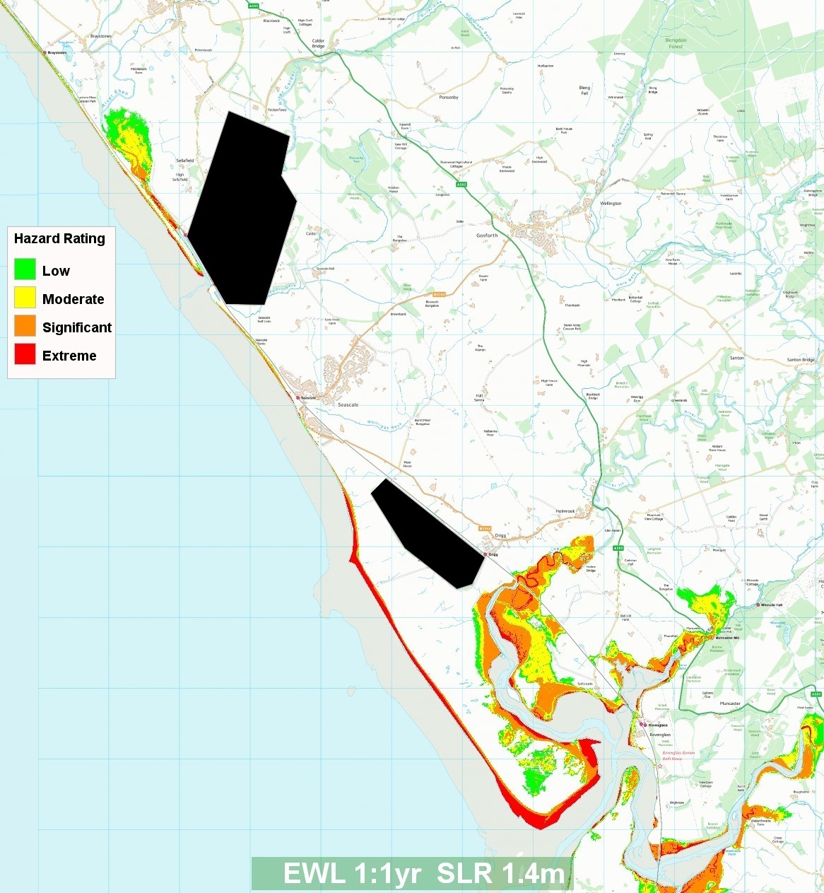
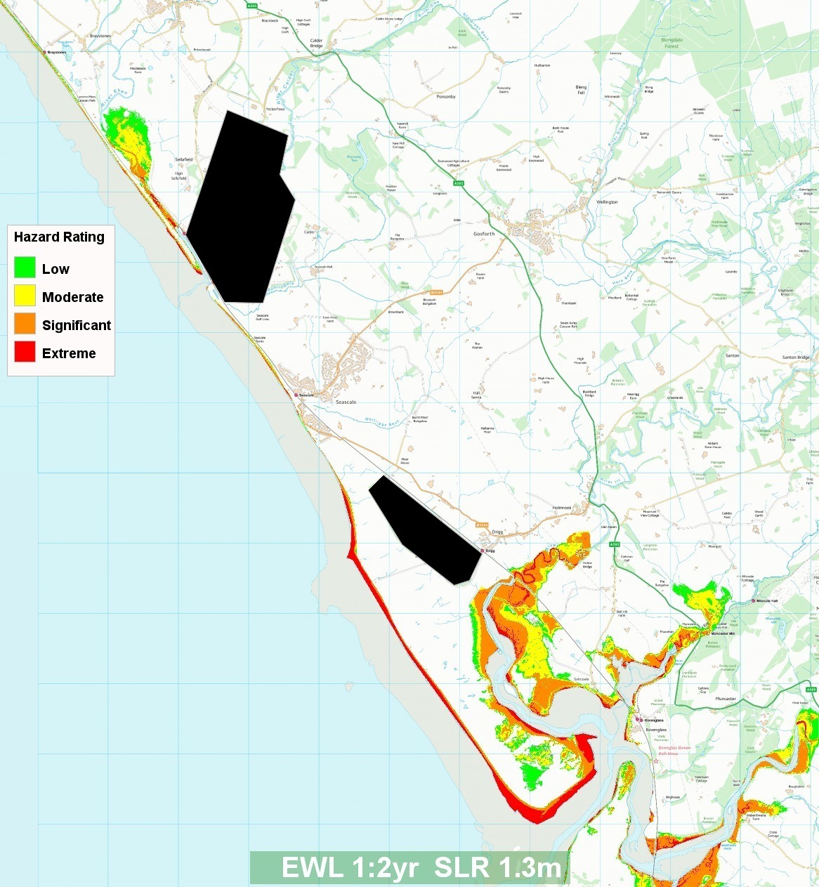
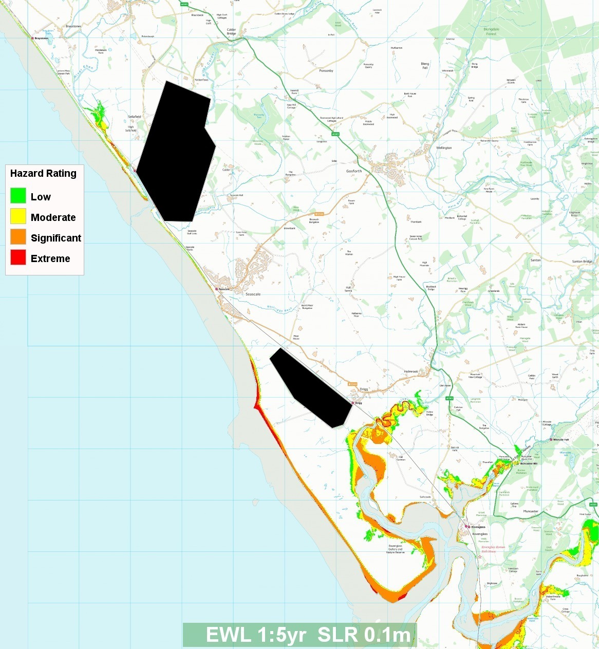
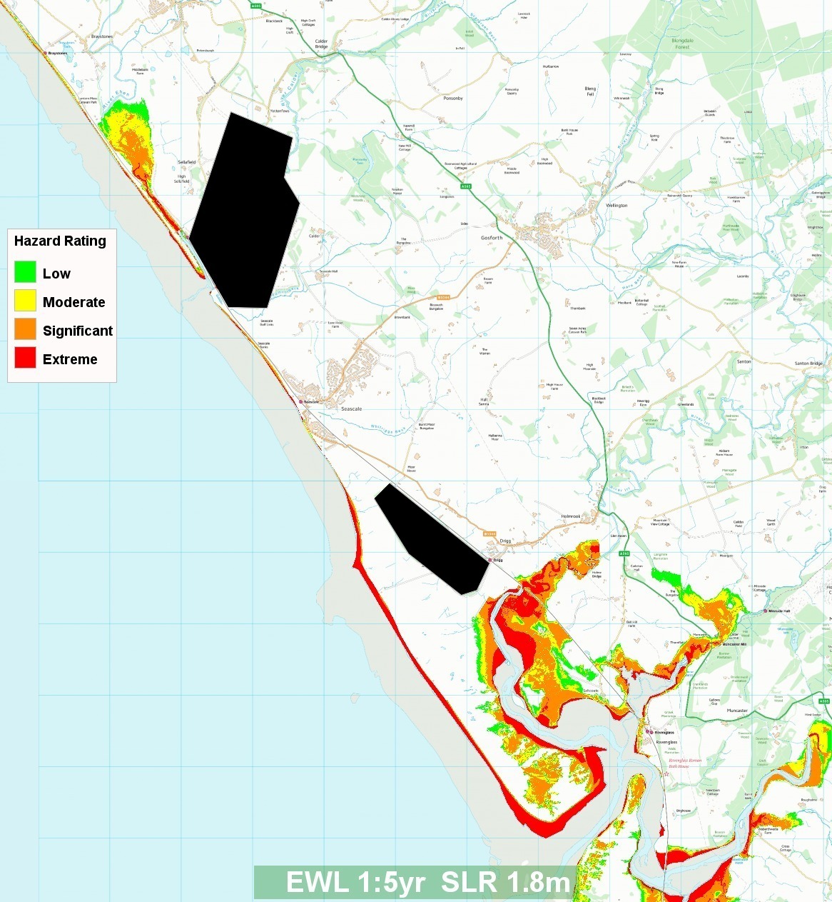
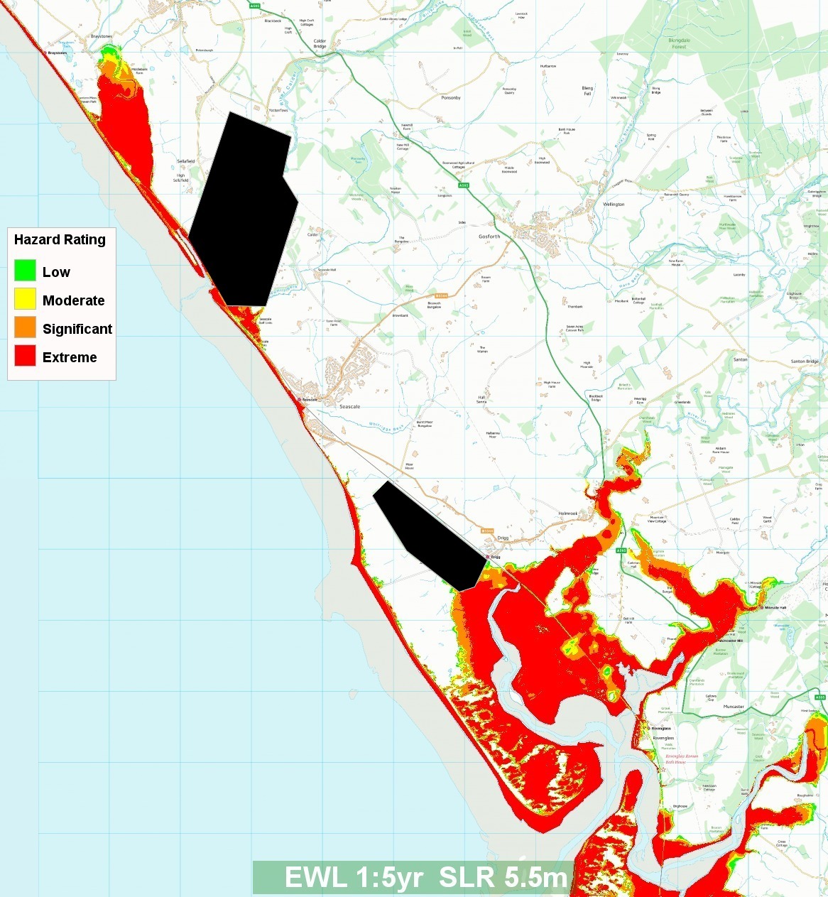
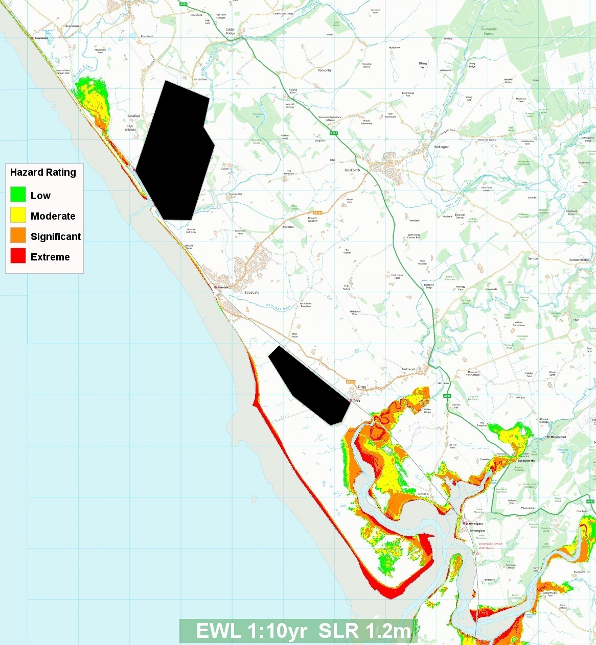
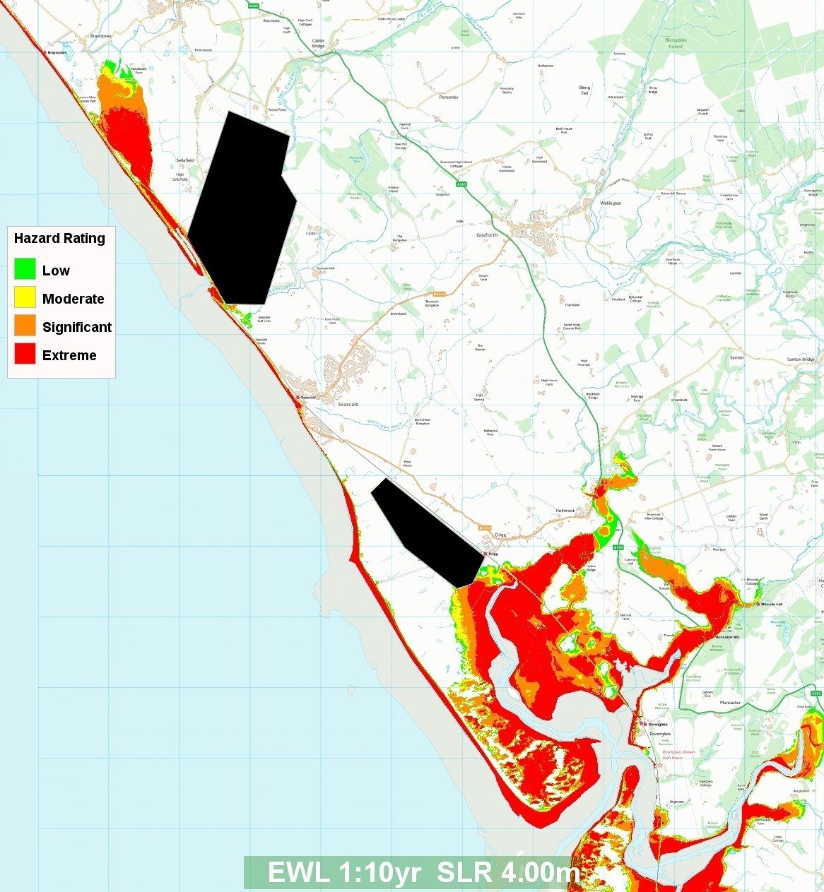
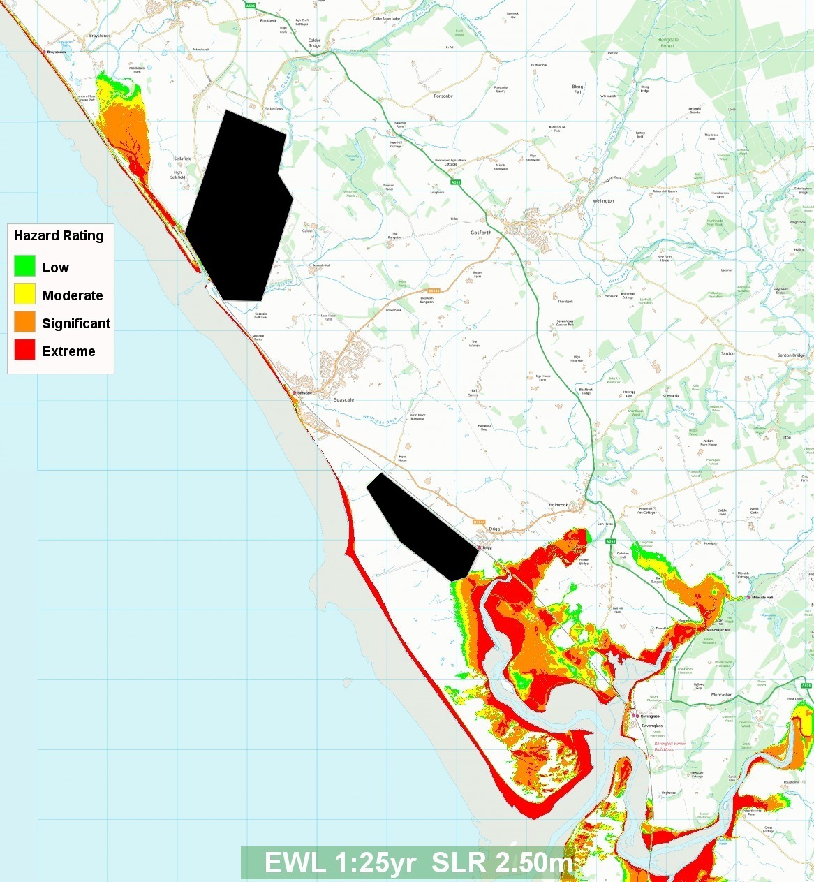
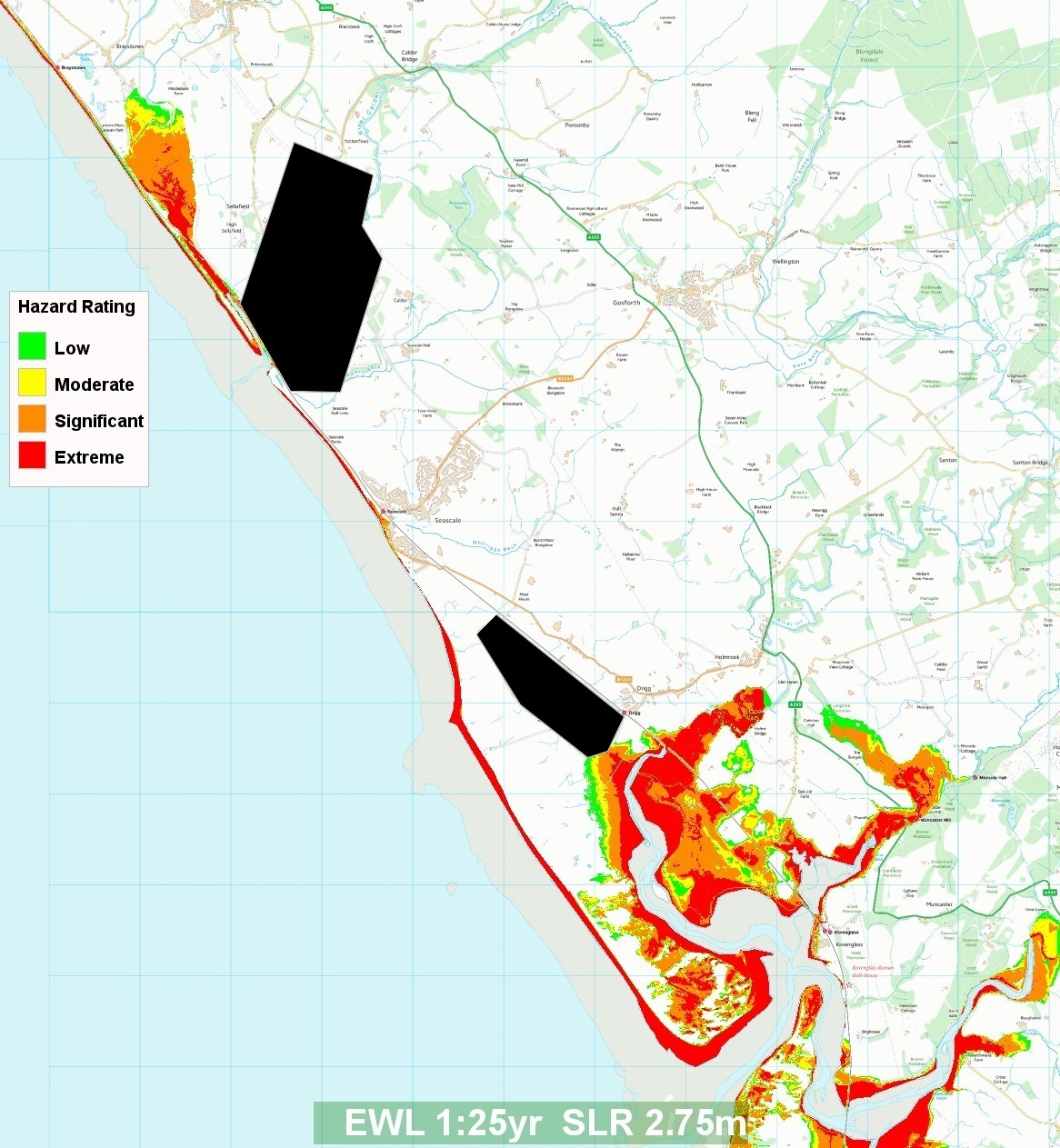
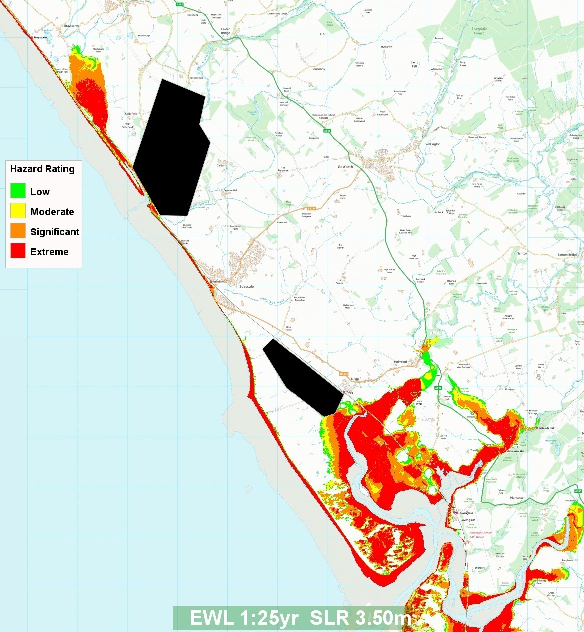
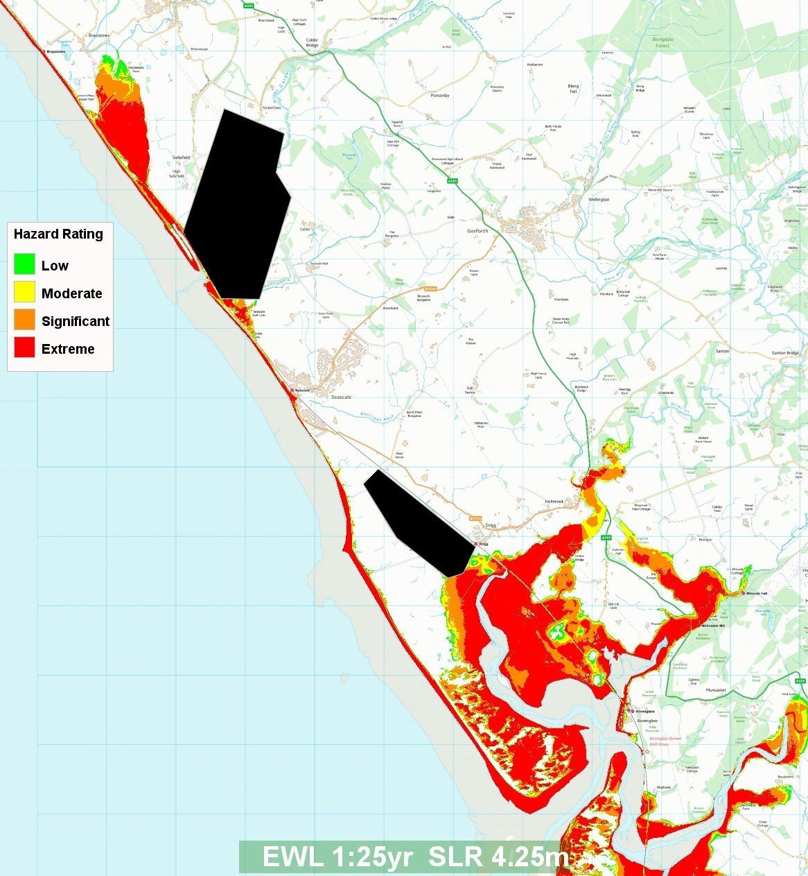
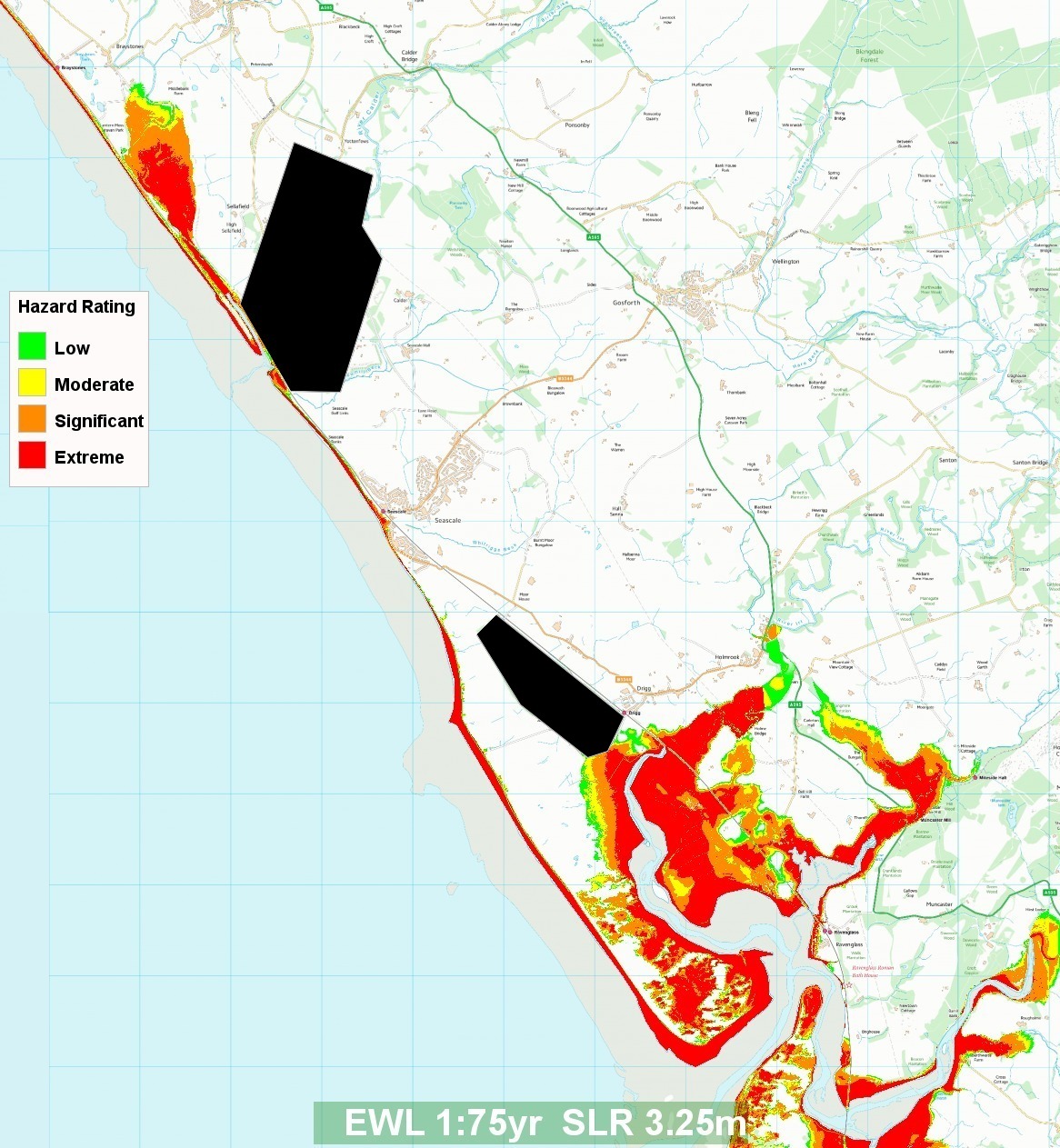
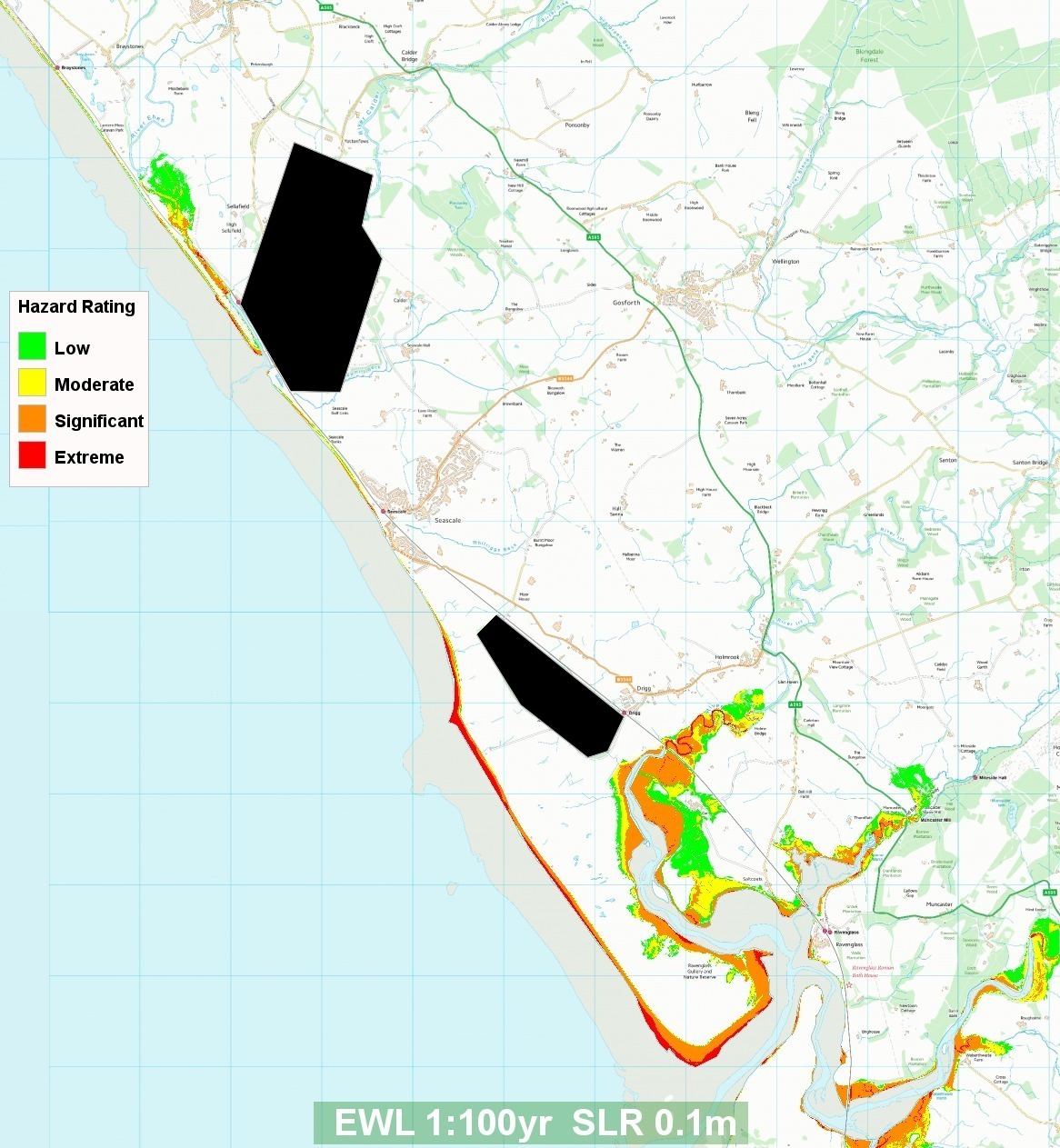
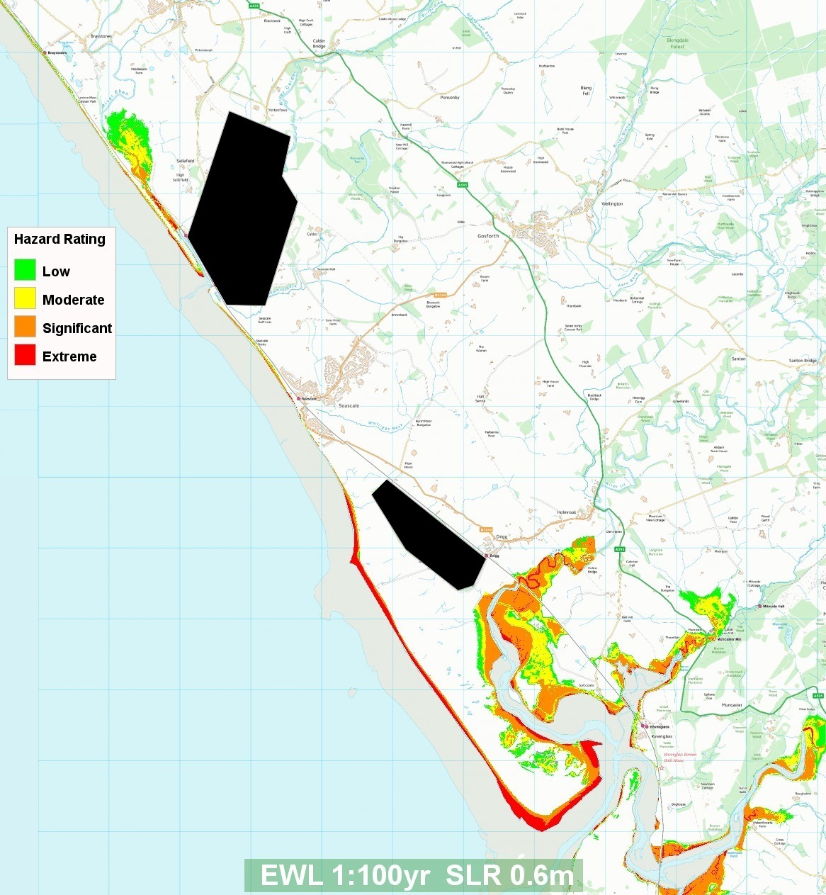
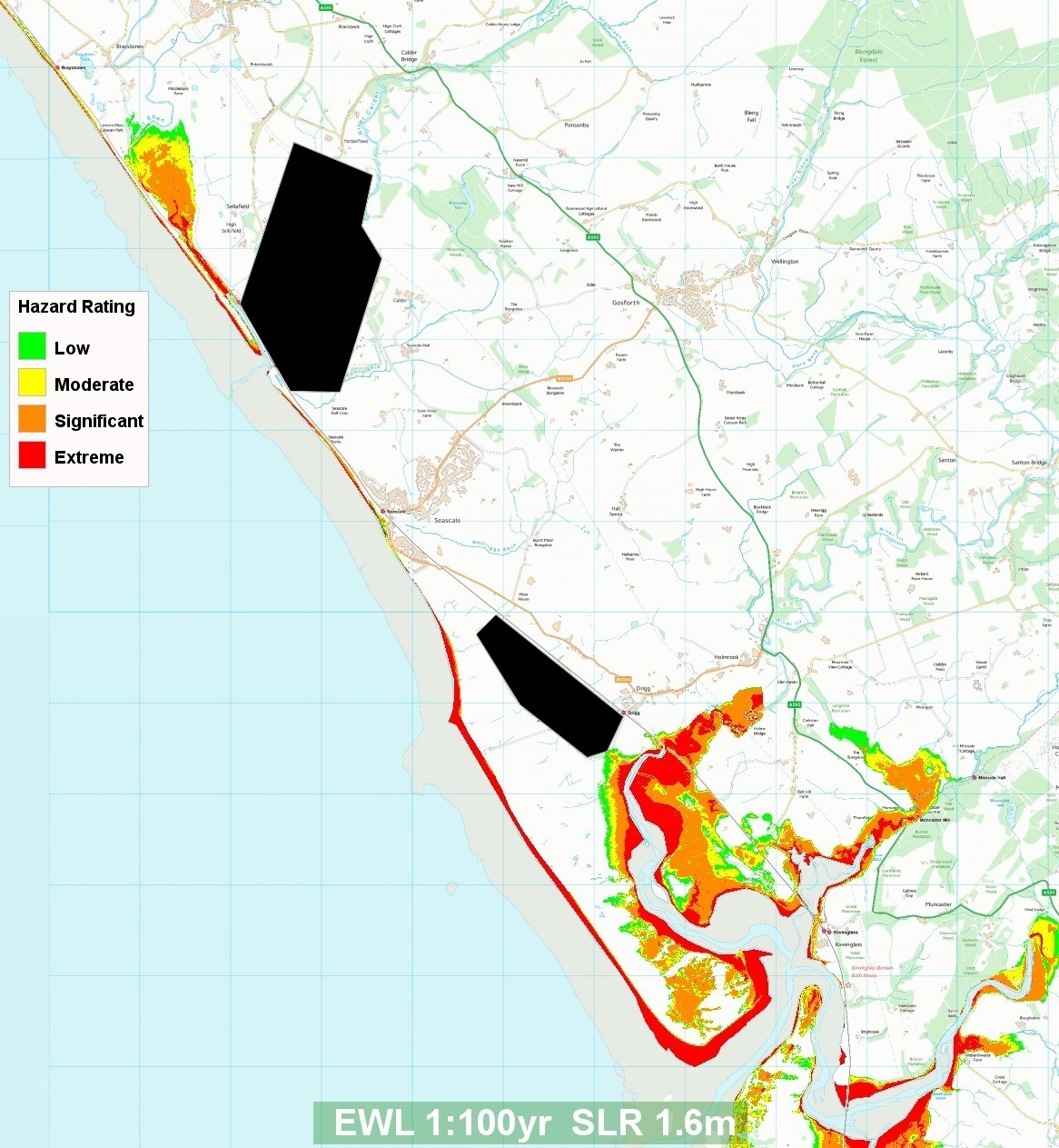
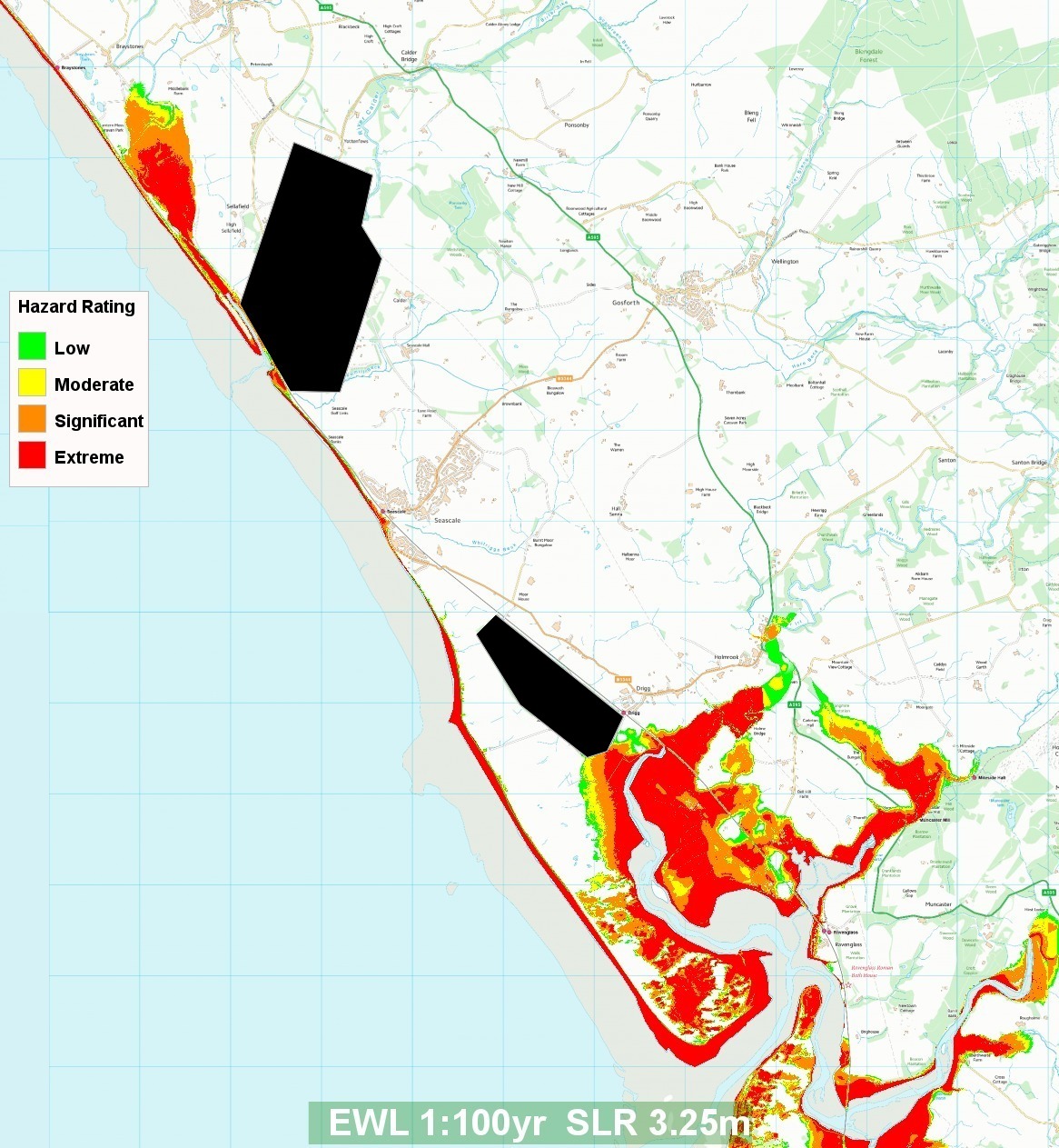
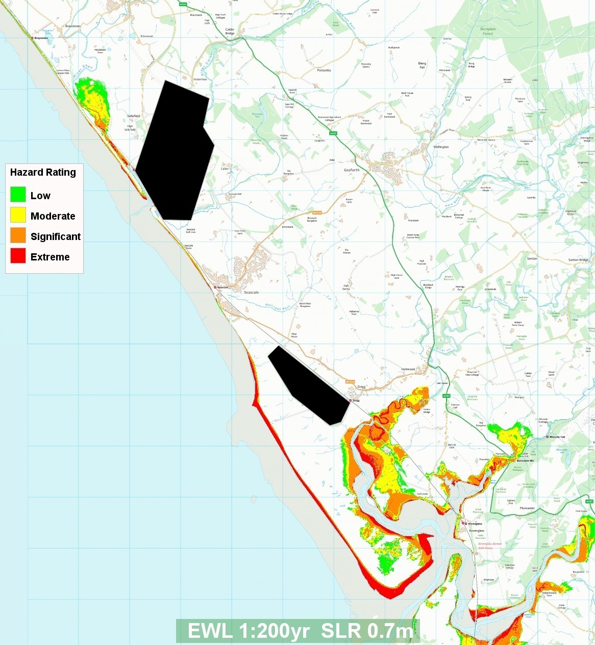
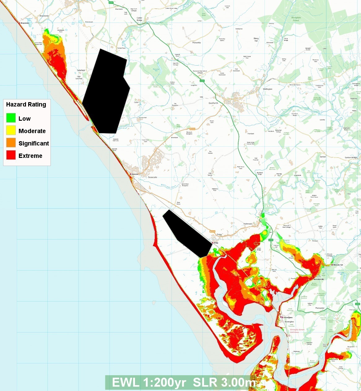
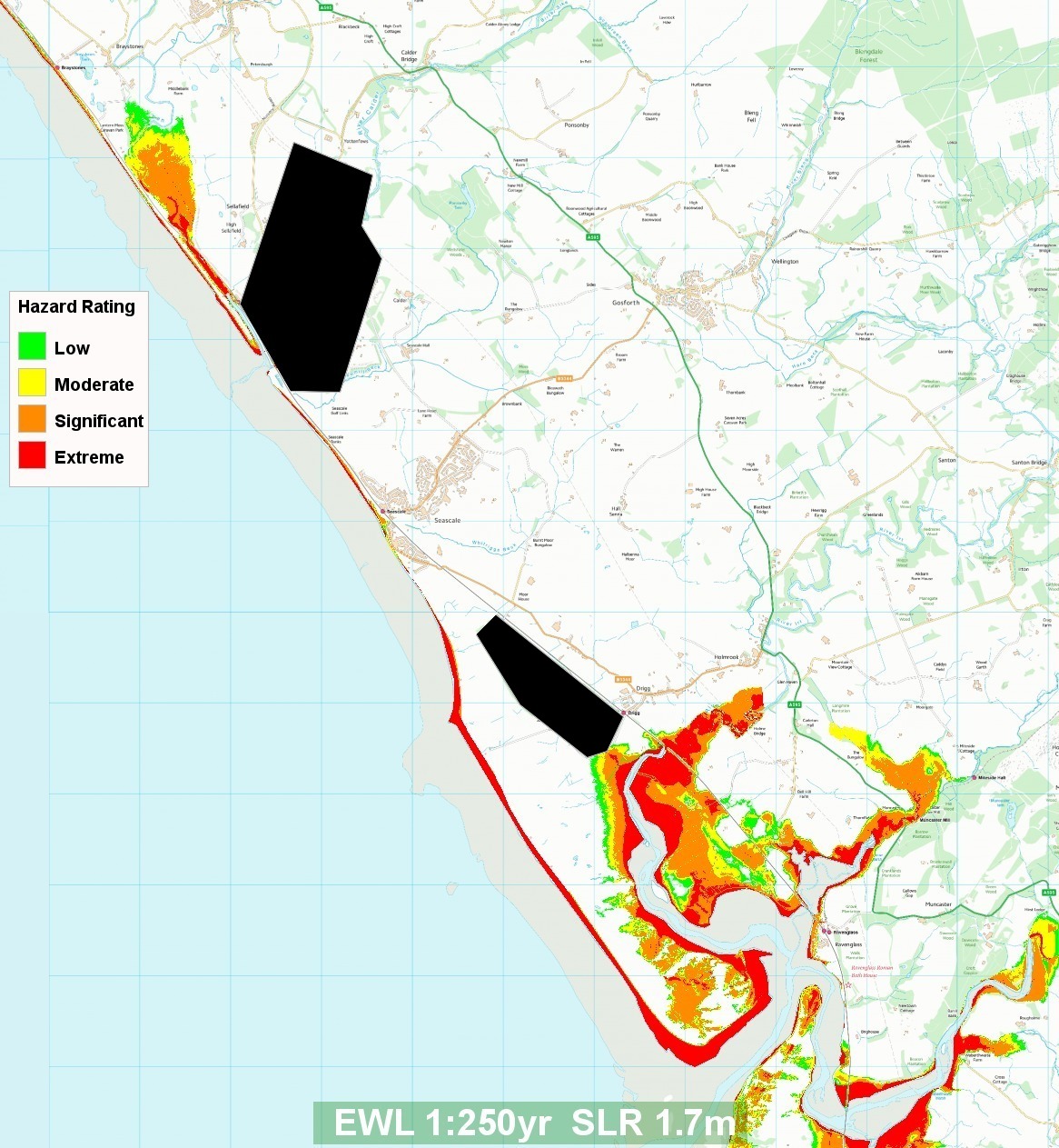
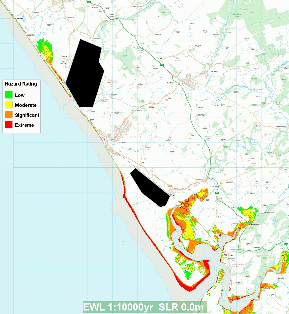